Edon, Ohio

Last updated

Edon, Ohio
Elevators, Edon, Ohio.jpg
Grain elevators on the south side of Edon
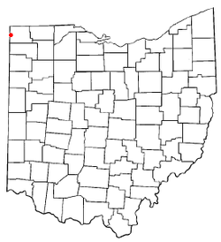
OHMap-doton-Edon.png
Location of Edon, Ohio
Map of Williams County Ohio Highlighting Edon Village.png
Location of Edon in Williams County
Coordinates: 41°33′22″N84°46′10″W / 41.55611°N 84.76944°W / 41.55611; -84.76944
Country United States
State Ohio
County Williams
Area
[1]
  Total1.10 sq mi (2.84 km2)
  Land1.10 sq mi (2.84 km2)
  Water0.00 sq mi (0.00 km2)
Elevation
[2]
899 ft (274 m)
Population
 (2020)
  Total796
  Density725.62/sq mi (280.24/km2)
Time zone UTC-5 (Eastern (EST))
  Summer (DST) UTC-4 (EDT)
ZIP code
43518
Area code 419
FIPS code 39-24640 [3]
GNIS feature ID2398790 [2]
Website http://www.edon-ohio.com/

Edon is a village in Williams County, Ohio, United States. The population was 796 at the 2020 census.

Contents

History

Edon was platted in 1867. [4] A post office has been in operation at Edon since 1867. [5]

Geography

Edon is located in northwest Ohio approximately 2 miles east of the Indiana state line, at the intersection of Ohio Routes 34 and 49. [6]

According to the United States Census Bureau, the village has a total area of 1.12 square miles (2.90 km2), all land. [7]

Demographics

Historical population
CensusPop.Note
1880 513
1890 60117.2%
1900 74023.1%
1910 678−8.4%
1920 610−10.0%
1930 581−4.8%
1940 6359.3%
1950 6451.6%
1960 75717.4%
1970 8036.1%
1980 94717.9%
1990 880−7.1%
2000 8982.0%
2010 834−7.1%
2020 796−4.6%
U.S. Decennial Census [8]

2010 census

As of the census [9] of 2010, there were 834 people, 339 households, and 225 families living in the village. The population density was 744.6 inhabitants per square mile (287.5/km2). There were 369 housing units at an average density of 329.5 per square mile (127.2/km2). The racial makeup of the village was 98.0% White, 0.1% African American, 0.2% Native American, 0.2% Asian, and 1.4% from two or more races. Hispanic or Latino of any race were 0.8% of the population.

There were 339 households, of which 31.6% had children under the age of 18 living with them, 52.5% were married couples living together, 8.6% had a female householder with no husband present, 5.3% had a male householder with no wife present, and 33.6% were non-families. 28.6% of all households were made up of individuals, and 15% had someone living alone who was 65 years of age or older. The average household size was 2.46 and the average family size was 3.02.

The median age in the village was 37.8 years. 25.5% of residents were under the age of 18; 9% were between the ages of 18 and 24; 25.1% were from 25 to 44; 22.8% were from 45 to 64; and 17.7% were 65 years of age or older. The gender makeup of the village was 48.1% male and 51.9% female.

2000 census

As of the census [3] of 2000, there were 898 people, 360 households, and 249 families living in the village. The population density was 863.2 inhabitants per square mile (333.3/km2). There were 375 housing units at an average density of 360.5 per square mile (139.2/km2). The racial makeup of the village was 98.89% White, 0.45% Asian, 0.22% from other races, and 0.45% from two or more races. Hispanic or Latino of any race were 0.33% of the population.

There were 360 households, out of which 34.2% had children under the age of 18 living with them, 56.9% were married couples living together, 10.0% had a female householder with no husband present, and 30.6% were non-families. 26.7% of all households were made up of individuals, and 14.7% had someone living alone who was 65 years of age or older. The average household size was 2.49 and the average family size was 3.03.

In the village, the population was spread out, with 27.7% under the age of 18, 6.7% from 18 to 24, 28.4% from 25 to 44, 21.5% from 45 to 64, and 15.7% who were 65 years of age or older. The median age was 36 years. For every 100 females there were 89.9 males. For every 100 females age 18 and over, there were 86.5 males.

The median income for a household in the village was $43,500, and the median income for a family was $48,214. Males had a median income of $33,125 versus $20,900 for females. The per capita income for the village was $17,099. About 3.8% of families and 5.2% of the population were below the poverty line, including 5.9% of those under age 18 and 14.3% of those age 65 or over.

Education

Edon High School is a public high school in Edon, and is the only high school in the Edon Northwest Local Schools district. Their nickname is the Bombers. They are members of the Buckeye Border Conference and, for football only, the Toledo Area Athletic Conference.

Notable alumni of Edon High School include Mel Held, a major league pitcher for the Baltimore Orioles in 1956, and Dave Herman, who went on to play football collegiately at Michigan State University from 1960 to 1964. Herman then played professionally with the New York Jets from 1964 to 1973, twice earning all-pro honors. He was the starting offensive right tackle in the Jets' 16–7 win over the Baltimore Colts in Super Bowl III.

Edon has a public library, a branch of the Williams County Public Library. [10]

Related Research Articles

<span class="mw-page-title-main">Williams County, Ohio</span> County in Ohio, United States

Williams County is a county located in the U.S. state of Ohio. As of the 2020 census, the population was 37,102. Its county seat is Bryan. The county was created in 1820 and later organized in 1824. It is named for David Williams, one of the captors of John André in the American Revolutionary War.

<span class="mw-page-title-main">Castalia, Ohio</span> Village in Ohio, United States

Castalia is a village in Erie County, Ohio, United States. The population was 774 at the 2020 census. It is part of the Sandusky, Ohio Metropolitan Statistical Area.

<span class="mw-page-title-main">Addyston, Ohio</span> Village in Ohio, United States

Addyston is a village in Miami Township, Hamilton County, Ohio, United States. Located along the Ohio River, it is a western suburb of the neighboring city of Cincinnati. The population was 927 at the 2020 census.

<span class="mw-page-title-main">Evendale, Ohio</span> Village in Ohio, United States

Evendale is a village in Hamilton County, Ohio, United States, within the Cincinnati metropolitan area. The population was 2,669 at the 2020 census.

<span class="mw-page-title-main">Greenwich, Ohio</span> Village in Ohio, United States

Greenwich is a village in Huron County, Ohio, United States. The population was 1,409 at the 2020 census. It is served by a branch of the Willard Memorial Library.

<span class="mw-page-title-main">Monroeville, Ohio</span> Village in Ohio, United States

Monroeville is a village in Huron County, Ohio, United States. The population was 1,300 at the 2020 census.

<span class="mw-page-title-main">Hanover, Ohio</span> Village in Ohio, United States

Hanover is a village in Licking County, Ohio, United States. The population was 1,270 at the 2020 census. The village lies along Ohio State Route 16.

<span class="mw-page-title-main">Tarlton, Ohio</span> Village in Ohio, United States

Tarlton is a village in Fairfield and Pickaway counties in the U.S. state of Ohio. The population was 254 at the 2020 census.

<span class="mw-page-title-main">Gibsonburg, Ohio</span> Village in Ohio, United States

Gibsonburg is a village in Sandusky County, Ohio, United States, about 33 miles (53 km) southeast of Toledo. The population was 2,452 at the 2020 census. The National Arbor Day Foundation has designated Gibsonburg as a Tree City USA.

<span class="mw-page-title-main">Helena, Ohio</span> Village in Ohio, United States

Helena is a village in Sandusky County, Ohio, United States. The population was 211 at the 2020 census.

<span class="mw-page-title-main">Limaville, Ohio</span> Census-designated place in Ohio, United States

Limaville is a census-designated place (CDP) and former village in Stark County, Ohio, United States. The population was 151 at the 2020 census. It is part of the Canton–Massillon Metropolitan Statistical Area.

<span class="mw-page-title-main">Beverly, Ohio</span> Village in Ohio, United States

Beverly is a village in Washington County, Ohio, United States. The population was 1,233 at the 2020 census. It is part of the Marietta micropolitan area.

<span class="mw-page-title-main">Macksburg, Ohio</span> Village in Ohio, United States

Macksburg is a village in Washington County, Ohio, United States, along the West Fork of Duck Creek. The population was 120 at the 2020 census. The village is about 28 miles (45 km) south of Cambridge, Ohio.

<span class="mw-page-title-main">Blakeslee, Ohio</span> Village in Ohio, United States

Blakeslee is a village in Williams County, Ohio, United States. The population was 104 at the 2020 census.

<span class="mw-page-title-main">Edgerton, Ohio</span> Village in Ohio, United States

Edgerton is a village in Williams County, Ohio, United States in the extreme northwest corner of the state. The population was 1,881 at the 2020 census.

<span class="mw-page-title-main">Holiday City, Ohio</span> Village in Ohio, United States

Holiday City is a village in Williams County, Ohio, United States. The population was 48 at the 2020 census.

<span class="mw-page-title-main">Montpelier, Ohio</span> Village in Ohio, United States

Montpelier is a village in Williams County, Ohio, United States. The population was 3,942 at the 2020 census.

<span class="mw-page-title-main">Wilson, Ohio</span> Village in Ohio, United States

Wilson is a village in Belmont and Monroe counties in the U.S. state of Ohio. The population was 129 at the 2020 census. It is part of the Wheeling metropolitan area.

<span class="mw-page-title-main">Buckeye Lake, Ohio</span> Village in Ohio, United States

Buckeye Lake is a village in Fairfield and Licking counties in the U.S. state of Ohio. The population was 2,520 at the 2020 census. It is named for Buckeye Lake, a large lake along which the village is built.

<span class="mw-page-title-main">Gratiot, Ohio</span> Village in Ohio, United States

Gratiot is a village in Licking and Muskingum counties in the U.S. state of Ohio. The population was 215 at the 2020 census.

References

  1. "ArcGIS REST Services Directory". United States Census Bureau. Retrieved September 20, 2022.
  2. 1 2 U.S. Geological Survey Geographic Names Information System: Edon, Ohio
  3. 1 2 "U.S. Census website". United States Census Bureau . Retrieved January 31, 2008.
  4. "County Information (Williams County, Ohio)". Archived from the original on February 22, 2014. Retrieved November 3, 2015.
  5. "Williams County". Jim Forte Postal History. Archived from the original on November 20, 2015. Retrieved March 2, 2015.
  6. "US Gazetteer files: 2010, 2000, and 1990". United States Census Bureau. February 12, 2011. Retrieved April 23, 2011.
  7. "US Gazetteer files 2010". United States Census Bureau. Archived from the original on January 25, 2012. Retrieved January 6, 2013.
  8. "Census of Population and Housing". Census.gov. Retrieved June 4, 2015.
  9. "U.S. Census website". United States Census Bureau . Retrieved January 6, 2013.
  10. "Hours & Locations". Williams County Public Library. Retrieved March 3, 2018.