The Toamasina Province is a former province of Madagascar with an area of 71,911 km². It had a population of 2,855,600 (2004). Its capital was Toamasina, the most important seaport of the country. The province was also known as Tamatave Province.

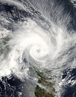
Intense Tropical Cyclone Leon–Eline was the longest-lived Indian Ocean tropical cyclone on record, traveling over 11,000 km (6,800 mi) during its 29‑day duration throughout the entire month of February. The cyclone formed on February 1, 2000, in the Australian basin as Tropical Cyclone Leon, and was renamed Eline after crossing 90° E into the South-West Indian Ocean; there, the Météo-France office in Réunion (MFR) tracked the storm's movement and intensity. Late on February 17, Eline made landfall near Mahanoro, Madagascar, with 10‑minute winds of 165 km/h (103 mph). The storm rapidly weakened over land, but restrengthened in the Mozambique Channel to reach peak 10‑minute winds of 185 km/h (115 mph), making it an intense tropical cyclone. On February 22, Eline made landfall about 80 km (50 mi) south of Beira, Mozambique, near peak intensity. Eline quickly weakened over land as it moved across Southern Africa, finally dissipating over eastern Namibia on February 29.
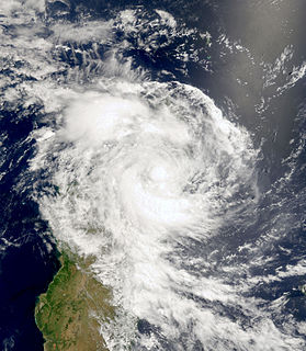
Tropical Cyclone Elita was an unusual tropical cyclone that made landfall on Madagascar three times. The fifth named storm of the 2003–04 South-West Indian Ocean cyclone season, Elita developed in the Mozambique Channel on January 24, 2004. It strengthened to tropical cyclone status before striking northwestern Madagascar on January 28; it was the first storm to strike western Madagascar at that intensity since Cyclone Cynthia in 1991. Elita weakened to tropical depression status while crossing the island, and after exiting into the southwest Indian Ocean, it turned to the west and moved ashore in eastern Madagascar on January 31. After once again crossing the island, the cyclone reached the Mozambique Channel and re-intensified. Elita turned to the southeast to make its final landfall on February 3 along southwestern Madagascar. Two days later, it underwent an extratropical transition; subsequently, the remnant system moved erratically before dissipating on February 13.

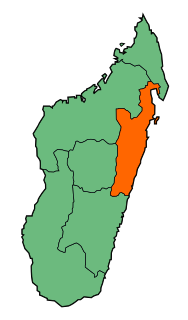
Atsinanana is a coastal region in eastern Madagascar. It borders Analanjirofo region in the north, Alaotra-Mangoro in the west, Vakinankaratra and Amoron'i Mania in the southwest, and Vatovavy and Fitovinany in south. The region contains over 285km of coastline, which includes many beaches and cultural heritage sites.
Hubert Rakotoson is a Malagasy politician. A member of the National Assembly of Madagascar, he was elected as a member of the Tiako I Madagasikara party; he represents the constituency of Mahanoro.

Hippotion saclavorum is a moth of the family Sphingidae. It is known from Madagascar, In the town of Ambinanindrano, 50km west of Mahanoro. ref>Carcasson, R. H. (1967). "Revised Catalogue of the African Sphingidae (Lepidoptera) with Descriptions of the East African species". Journal of the East Africa Natural History Society and National Museum. 26 (3): 1–173 – via Biodiversity Heritage Library.</ref>

The 1981–82 South-West Indian Ocean cyclone season was destructive and deadly in Madagascar, where four cyclones killed 100 people and caused $250 million (USD) in damage. The season was fairly active, lasting from October to May. There were nine named storms that attained gale-force winds, or at least 65 km/h (40 mph). Five of the storms attained tropical cyclone status, which have 10-minute sustained winds of at least 120 km/h (75 mph).

Mahanoro is a city and urban municipality located in the Atsinanana region of eastern Madagascar, along the coast.
Ambodiharina[vatʷˈmanɖʐʲ] is a village and commune in the Mahanoro District, Atsinanana Region, Madagascar.
In early 2000, severe flooding occurred in the African nation of Madagascar after Cyclone Leon–Eline and Severe Tropical Storm Gloria struck the nation within a two-week period. The first storm, Eline, formed on February 1, and took an extended track across the Indian Ocean, eventually making landfall near Mahanoro on February 17. On March 1, Gloria struck northeastern Madagascar, and like Eline, moved southwestward across the country.

The lance-nosed chameleon, also known as a blade chameleon is endemic to eastern Madagascar.
Fenoarivo-Atsinanana is a district of Analanjirofo in Madagascar.
Mahanoro is a district of Atsinanana in Madagascar.
Mananara Avaratra is a district of Analanjirofo in Madagascar.
Route nationale 11a is a secondary highway in Madagascar of 204 km, running from Antsampanana to Mahanoro, to the Mangoro River. It crosses the region of Atsinanana.
Route nationale 11 is a secondary highway in Madagascar of 204 km, running from Mahanoro to Mananjary. It crosses the regions of Atsinanana and Vatovavy-Fitovinany.
Mahanoro is a rural commune in Madagascar. It belongs to the district of Fenerive Est, which is a part of Analanjirofo Region.
Betsizaraina is a rural commune located in Atsinanana, at the east coast of Madagascar. It is located south of Mahanoro at the mouth of the Mangoro River to the Indian Ocean.
Ambodibonara is a village and commune in the Mahanoro District, Atsinanana Region, Madagascar.
Befotaka is a village and rural commune in the Mahanoro (district) in the Atsinanana Region, Madagascar.

