
Antananarivo, also known by its colonial shorthand form Tana, is the capital and largest city of Madagascar. The administrative area of the city, known as Antananarivo-Renivohitra, is the capital of Analamanga region. The city sits at 1,280 m (4,199 ft) above sea level in the center of the island, the highest national capital by elevation among the island countries. It has been the country's largest population center since at least the 18th century. The presidency, National Assembly, Senate and Supreme Court are located there, as are 21 diplomatic missions and the headquarters of many national and international businesses and NGOs. It has more universities, nightclubs, art venues, and medical services than any city on the island. Several national and local sports teams, including the championship-winning national rugby team, the Makis are based here.

Mazatlán is a city in the Mexican state of Sinaloa. The city serves as the municipal seat for the surrounding municipio, known as the Mazatlán Municipality. It is located on the Pacific coast, across from the southernmost tip of the Baja California Peninsula.

Altorricón or El Torricó is a municipality located in the comarca of La Litera/La Llitera in the province of Huesca, Aragon, Spain. With an extension of 32.03 km2, the municipal district of Altorricón lies on the southern part of La Llitera, limiting with El Segrià (Almacelles). The district is surrounded north and south by Tamarite de Litera. The municipality contains the town of Altorricón and the uninhabited towns of Cuquet, Montanera and Lo Tossal as well as the old church of San Bartolomé de Altorricón.

Lipjan or Lipljan is a town and municipality located in the Pristina District of Kosovo. According to the 2011 census, the town of Lipjan has 6,870 inhabitants, while the municipality has 57,605 inhabitants.

Llafranc is one of three coastal towns belonging to the municipality of Palafrugell, province of Girona, Spain, the other two being Calella de Palafrugell and Tamariu. It is part of the Costa Brava, the coastal region of northeastern Catalonia, in the comarca of Baix Empordà.

Tshikapa is the capital city of Kasai Province in the Democratic Republic of the Congo. The city is located 60 km (37 mi) north of the Angolan border and 189 km (117 mi) west of Kananga at the confluence of the Tshikapa and Kasai rivers. According to records published by the Utrecht University library, the population of the city has grown from 38,900 in 1970 to 180,900 in 1994. However, the two recent Congo wars have caused great flux in population rendering current figures unreliable. Tshikapa has been a site of diamond mining since its founding in the early 20th century. The city was founded by Forminière, an American/Belgian mining consortium which discovered diamonds near this location in the early 1900s.

Morondava is a city located in Menabe Region, of which it is the capital, in Madagascar. It is located in the delta of the Morandava River at 20°17′5″S44°19′3″E. Its population as of the 2018 census, was 53,510.
Ambatofinandrahana is a municipality in Ambatofinandrahana District in central Madagascar.
Sahasinaka is a municipality in the Manakara district of the Fitovinany Region in Madagascar.
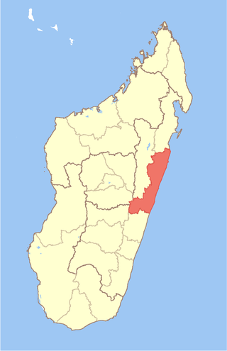
Atsinanana is a coastal region in eastern Madagascar. It borders Analanjirofo region in the north, Alaotra-Mangoro in the west, Vakinankaratra and Amoron'i Mania in the southwest, and Vatovavy and Fitovinany in south. The region contains over 285km of coastline, which includes many beaches and cultural heritage sites.
Manakambahiny Ouest or Manakambahiny Andrefana is a rural municipality in Madagascar. It belongs to the district of Ambatondrazaka, which is a part of Alaotra-Mangoro Region. The population of the commune was estimated to be approximately 22,000 in 2001 commune census.
Marojejy National Park is a national park in the Sava region of northeastern Madagascar. It covers 55,500 ha (214 sq mi) and is centered on the Marojejy Massif, a mountain chain that rises to an elevation of 2,132 m (6,995 ft). Access to the area around the massif was restricted to research scientists when the site was set aside as a strict nature reserve in 1952. In 1998, it was opened to the public when it was converted into a national park. It became part of the World Heritage Site known as the Rainforests of the Atsinanana in 2007. "Unique in the world, a place of dense, jungly rainforests, sheer high cliffs, and plants and animals found nowhere else on earth", Marojejy National Park has received plaudits in the New York Times and Smithsonian Magazine for its natural beauty and rich biodiversity that encompasses critically endangered members of the silky sifaka. To that end, a global consortium of conservation organizations, including the Lemur Conservation Foundation, Duke Lemur Center and Madagascar National Parks, have sought to promote research and conservation programs in Marojejy National Park, neighboring Anjanaharibe-Sud Reserve and Antanetiambo Private Reserve, to protect the endemic flora and fauna that reside in northeastern Madagascar. In addition, these organizations have implemented a variety of community-based initiatives to mitigate human encroachment on the park, such as poaching and selective logging, by encouraging local communities to engage in afforestation and silvicultural initiatives to promote a sustainable alternative to mining, slash-and-burn agriculture, and wood collection.

Walewale is a town and the capital of Mamprusi West Municipal in the Northeast Region of Ghana. The West Mamprusi Municipal is one of the 261 Metropolitan, Municipal and District Assemblies (MMDAs) in Ghana, and forms part of the 6 MMDAs in the Northeast Region. The West Mamprusi Municipal is one of 45 new districts created in 1988 under the Government of Ghana’s decentralization and was later replaced with LI 2061 in 2012. With its administrative capital as Walewale,

The Tsiribihina is a river of western Madagascar.

Andevoranto[andevʷˈrantʷ] is a rural municipality in the Brickaville District, Atsinanana Region, Madagascar.
Ambodiharina[vatʷˈmanɖʐʲ] is a village and commune in the Mahanoro District, Atsinanana Region, Madagascar.
Masomeloka[vatʷˈmanɖʐʲ] is a village and commune in the Mahanoro District, Atsinanana Region, Madagascar.

Ambinanindrano is a rural municipality located in the Mahanoro District, Atsinanana region of eastern Madagascar

Mananjary is a city on the East coast of Madagascar with a population of 25,222 inhabitants in 2018. It is the chief town of the Mananjary district and the Vatovavy region.

Paraíso is a municipality in Tabasco in south-eastern Mexico.


