The Toamasina Province is a former province of Madagascar with an area of 71,911 km². It had a population of 2,855,600 (2004). Its capital was Toamasina, the most important seaport of the country. The province was also known as Tamatave Province.

Antanifotsy[antaniˈfutsʲ] is a city, rural commune and a district located in Vakinankaratra Region in Madagascar. It is the eighth largest city in the country, with a population of 70,626 in 2004. The city is at 112 km from Antananarivo and at 60 km to Antsirabe on the RN7. Ilempona Gara, at the entrance of Antanifotsy, is a railway station on the Antananarivo - Antsirabe line.

Vatomandry is a town in and the administrative center of the Vatomandry District, Atsinanana Region, Madagascar. An airport serves the city.

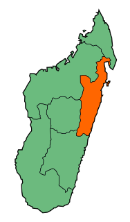
Atsinanana is a region in eastern Madagascar. It borders Analanjirofo region in north, Alaotra-Mangoro in west, Vakinankaratra and Amoron'i Mania in southwest and Vatovavy and Fitovinany in south.

Marovoay is a district in northwestern Madagascar. It is a part of Boeny Region and borders the districts of Mahajanga II in north, Boriziny and Mampikony in east, Ambato-Boeni in south and Mitsinjo in west. The area is 3,804 km2 (1,469 sq mi) and the population was estimated to be 182,742 in 2013.

Mangabe is a town and commune in Madagascar. It belongs to the district of Maevatanana, which is a part of Betsiboka Region. The population of the commune was estimated to be approximately 16,000 in 2001 commune census.

Antsirabe II is a rural district in Vakinankaratra Region, Madagascar. The district surrounds the urban district and city of Antsirabe. It also borders the district of Faratsiho to the north, Antanifotsy to the east and Betafo to the west, in addition to the region of Antanifotsy to the south. The district covers a total area of 2,471.31 km2, with a population estimated at 406,353 in 2013.

Antsampanana is a village in Atsinanana Region, Madagascar. It is located along Route Nationale 2 at its junction with RN 11 that leads south to Vatomandry and Mahanoro. Its market area is a common stopping point for trips.
Antanambao Manampotsy is a village and urban commune (municipality) located in the Atsinanana region of eastern Madagascar, and is the chief town of the Antanambao Manampontsy District.
Maintinandry[vatʷˈmanɖʐʲ] is a small village and commune in the Vatomandry District, Atsinanana Region, Madagascar.
Antanambao Manampotsy is a and district located in the Atsinanana Region of eastern Madagascar.
Vatomandry is a district located in Atsinanana Region, Madagascar.
Mahatsara or Mahatsara Est is a village and commune in the district of Brickaville Vohibinany (district), Atsinanana Region, Madagascar. The RN 2 and RN 2 crosses in the village of Antsampanana that belongs to the commune.
Ilaka Est is a rural commune (municipality) located in the Atsinanana region of eastern Madagascar, and belongs to the Vatomandry (district).
Tsivangiana is a rural commune (municipality) located in the Atsinanana region of eastern Madagascar, and belongs to the Vatomandry (district).
Ambalavolo is a rural commune located in the Atsinanana region of eastern Madagascar, and belongs to the Vatomandry (district).
Maintinandry is a small village and rural commune in the Vatomandry District, Atsinanana Region, Madagascar.
Fanandrana is a rural commune in the district of Toamasina II (district), in the region of Atsinanana, on the east coast of Madagascar. It is situated at the National road RN 2 at 26 km from Toamasina. The Ivondro River flows through the center of Fanandrana, and the Fanandrana river in its south.
'Amboditavolo is a village and commune in the Vatomandry (district) in the Atsinanana Region, Madagascar.
' Ambodivoananto is a village and commune in the Vatomandry (district) in the Atsinanana Region, Madagascar.


