
Antananarivo, also known by its colonial shorthand form Tana, is the capital and largest city of Madagascar. The administrative area of the city, known as Antananarivo-Renivohitra, is the capital of Analamanga region. The city sits at 1,280 m (4,199 ft) above sea level in the center of the island, the highest national capital by elevation among the island countries. It has been the country's largest population center since at least the 18th century. The presidency, National Assembly, Senate and Supreme Court are located there, as are 21 diplomatic missions and the headquarters of many national and international businesses and NGOs. It has more universities, nightclubs, art venues, and medical services than any city on the island. Several national and local sports teams, including the championship-winning national rugby team, the Makis are based here.

The Toamasina Province is a former province of Madagascar with an area of 71,911 km². It had a population of 2,855,600 (2004). Its capital was Toamasina, the most important seaport of the country. The province was also known as Tamatave Province.

Anjozorobe is a large town in the Analamanga Region, Madagascar, approximately 90 kilometers north-east of the capital Antananarivo. It has a population of 24,117 inhabitants in 2018.
Soavina is a rural commune in Analamanga Region, in the Central Highlands of Madagascar. It belongs to the district of Antananarivo-Atsimondrano and its populations numbers to 15,658 in 2018.

Vakinankaratra is a region in central Madagascar. The capital of the region is Antsirabe. Vakinankaratra covers an area of 16,599 kilometres, and had a population of 2,074,358 in 2018.

Analamanga is a region in central Madagascar, containing the capital Antananarivo and its surrounding metropolitan area. The region has an area of 17,488 square kilometres, and had a population of 4,325.226 in 2018.
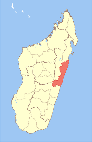
Atsinanana is a coastal region in eastern Madagascar. It borders Analanjirofo region in the north, Alaotra-Mangoro in the west, Vakinankaratra and Amoron'i Mania in the southwest, and Vatovavy in the south. The region contains over 285km of coastline, which includes many beaches and cultural heritage sites.

Andasibe is a rural municipality in Madagascar. It belongs to the district of Moramanga, which is a part of Alaotra-Mangoro Region. The population of the commune was estimated to be approximately 13493 in 2006.

The history of rail transport in Madagascar began at the start of the twentieth century, with the construction of a metre gauge line between Brickaville and Madagascar's capital, Tananarive. That line was the first section of the Tananarive–Côte Est railway (TCE) from Tananarive to Toamasina, the country's chief seaport. It eventually became the nucleus of a network of three railways, the Network North.

Intense Tropical Cyclone Geralda was a powerful tropical cyclone that caused catastrophic damage in Madagascar in late January 1994, among the strongest to hit the country. It was also the most intense tropical cyclone worldwide in 1994. Cyclone Geralda originated from an area of low pressure over the Indian Ocean on 25 January. Over the following few days, the depression underwent gradual intensification, reaching its peak intensity with ten-minute sustained winds of 200 km/h (120 mph) on 31 January. It eventually made landfall near Toamasina, Madagascar after weakening from its peak intensity, and substantially weakened within hours of moving onshore. By 5 February, Geralda had degenerated into a land depression, and became extratropical three days later. Geralda's remnants dissipated on 12 February.

Rianila is a river in the Atsinanana region in eastern Madagascar. It flows down from the central highlands to flow into the Indian Ocean south of Brickaville at Andevoranto. Its largest tributary is the Rongaronga, which joins it near Brickaville as well as the Iaroka and Vohitra Rivers.

Route nationale 2 (RN2) is a primary highway in Madagascar. The route runs from the capital city of Antananarivo to Toamasina, a city on the eastern coast of the Madagascar.

Andevoranto is a rural municipality in the Brickaville District, Atsinanana Region, Madagascar.
Chocolaterie Robert is the first commercial producer of locally produced chocolate in Madagascar. Bars of chocolate are the company's most widespread product and are sold under the name Chocolat Robert. The company was established in 1940 by the French-Reunionais Robert family in Toamasina and changed hands several times before being sold to a Malagasy business group run by the Ramanandraibe family, among the major Malagasy leaders driving economic development of the island in the post-colonial period.

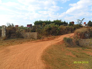
Brickaville District is an administrative district in Atsinanana Region, Madagascar; also known as Ampasimanolotra and Vohibinany. Brickaville is located along Route nationale 2, 105 km south of Toamasina and 220 km east of Antananarivo. It is also situated alongside the Rianila river. It is a railway station on the Antananarivo - East Coast line. Its main industries revolve around sugar.
Ambohitrimanjaka is a municipality in Madagascar. It belongs to the district of Ambohidratrimo (district), which is a part of Analamanga Region. It lies about 12 km West from the capital Antananarivo. It is well known for its manufacture of bricks, its fish, ducks and rice.
Ambohimalaza Miray is a rural municipality in Analamanga Region, in the Central Highlands of Madagascar. It belongs to the district of Antananarivo Avaradrano and its population numbers to 15,988 in 2018.
Mangamila is a municipality in the Analamanga Region, Madagascar, 69 km north-east of the capital Antananarivo, in the district of Anjozorobe.
Ankaraobato is a rural municipality in Analamanga Region, in the Central Highlands of Madagascar. It belongs to the district of Antananarivo-Atsimondrano and its populations numbers to 20,969 in 2019.

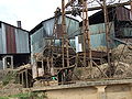 Sugarcane factory in Brickaville in 2007
 Bridge over Rianila river
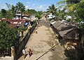 Typical residential area
 Inland harbour on river Rianila


