Fanandrana

Last updated
Fanandrana
Pont d'Ivondro - region Atsinanana - Madagascar.jpg
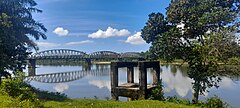
Ivondro bridge at Fanandrana
Madagascar location map.svg
Red pog.svg
Fanandrana
Location in Madagascar
Coordinates: 18°11′40″S49°22′45″E / 18.19444°S 49.37917°E / -18.19444; 49.37917
CountryFlag of Madagascar.svg  Madagascar
Region Atsinanana
District Toamasina II
Area
[1]
  Total
292 km2 (113 sq mi)
Elevation
15 m (49 ft)
Population
 (2019)Census
  Total
17,644
Time zone UTC3 (EAT)
Postal code
501

Fanandrana is a rural commune in the district of Toamasina II (district), in the region of Atsinanana, on the east coast of Madagascar. It is situated at the National road RN 2 at 26 km from Toamasina. The Ivondro River flows through the center of Fanandrana, and the Fanandrana river in its south.

Economy

The economy is based on agriculture. Rice is grown, other crops are oil palms, manioc, cloves, sugar cane and pepper. [2] [3]

In 2024 a prison of high security was inaugurated in Fanandrana, fokontany Antananambo. [4]

References

  1. ETUDE DE LA COMMERCIALISATION DU SUCRE BIO ET SES PERSPECTIVES
  2. "ANALYSE DE LA SITUATION DE LA CULTURE MARAÎCHERE DU LITTORAL CENTRE EST DE MADAGASCAR CAS DE LA COMMUNE RURALE DE FANANDRANA" (PDF). Archived from the original (PDF) on 2021-09-08. Retrieved 2021-09-08.
  3. Tsimanadino Herilanto Jean Théodurant ANDRIATSITOHAINA (2011-04-27). "APPORTS DE LA POPULATION RURALE AU DÉVELOPPEMENT ÉCONOMIQUE (CAS DU DISTRICT DE TOAMASINA II)" (PDF). Retrieved 2021-09-08.
  4. L'Express de Madagascar