Amenia, Illinois | |
|---|---|
 Amenia, Illinois  Amenia, Illinois | |
| Coordinates: 40°01′19″N88°39′59″W / 40.02194°N 88.66639°W | |
| Country | United States |
| State | Illinois |
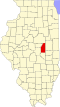
| County | Piatt |
| Elevation | 689 ft (210 m) |
| Time zone | UTC-6 (Central (CST)) |
| • Summer (DST) | UTC-5 (CDT) |
| Area code | 217 |
| GNIS feature ID | 422406 [1] |
Amenia is an unincorporated community in Piatt County, in the U.S. state of Illinois. [1]
The community was named after Amenia, New York, the native home of an early settler. [2]