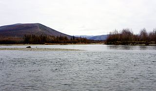
The Anadyr is a river in the far northeast Siberia which flows into the Gulf of Anadyr of the Bering Sea and drains much of the interior of Chukotka Autonomous Okrug. Its basin corresponds to the Anadyrsky District of Chukotka.

Chukotka Autonomous Okrug or Chukotka (Чукотка) is the easternmost federal subject in Russia. It is geographically located in the Far East region of the country, and is administratively part of the Far Eastern Federal District. Chukotka is the 2nd-least-populated federal subject at 50,526 (2010) and the least densely populated.

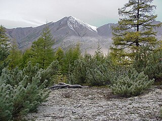
Lake El'gygytgyn is an impact crater lake located in the Chukotka Autonomous Okrug in northeast Siberia, about 150 km (93 mi) southeast of Chaunskaya Bay.
The Maly Anyuy is a river in the Kolyma basin in the Russian Far East. Most of the basin of the Maly Anyuy and its tributaries belongs to the Chukotka Autonomous Okrug administrative region of Russia.

The Bolshoy Anyuy is a river in the Kolyma basin in Far East Siberia. Administratively most of the basin of the Bolshoy Anyuy and its tributaries belong to the Chukotka Autonomous Okrug of Russia.
The Belaya is a south-flowing tributary of the Anadyr in the Chukotka Autonomous Okrug administrative region of Russia.

The Mayn is a river in Chukotka Autonomous Okrug in Russia, one of the major tributaries of the Anadyr. The length of the river is 475 kilometres (295 mi). The area of is drainage basin is 32,800 square kilometres (12,700 sq mi).
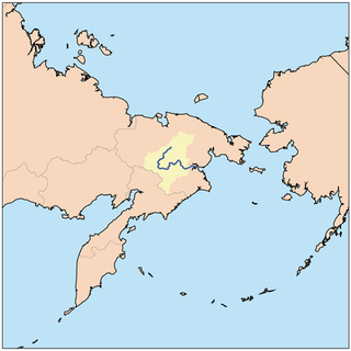
Anadyrsky District is an administrative and municipal district (raion), one of the six in Chukotka Autonomous Okrug, Russia. It is located in the central and southern parts of the autonomous okrug and borders with Chaunsky District in the northwest, Iultinsky District in the north and northeast, the Gulf of Anadyr in the east, Koryak Okrug in the south, and with Bilibinsky District in the west and northwest. It also completely surrounds the territory of the town of okrug significance of Anadyr. The area of the district is 287,900 square kilometers (111,200 sq mi). Its administrative center is the town of Anadyr. Population: 6,935 (2010 Census); 8,007 (2002 Census); 40,475 (1989 Census).

The Anyuy Mountains, also known as South Anyuy Range are a range of mountains in far north-eastern Russia. Administratively the range is part of the Chukotka Autonomous Okrug, Russia. The area of the range is largely uninhabited.
The Kolyma Mountains or Kolyma Upland is a mountain range in northeastern Siberia, lying mostly within the Magadan Oblast, along the shores of the Sea of Okhotsk in the Kolyma region. The range's highest point is Mount Nevskaya in the Omsukchan Range at 1,828 meters (5,997 ft).
The Enmyvaam is a river located in the Chukotka Autonomous Okrug in the Russian Far East, about 150 km (93 mi) southeast of Chaunskaya Bay. It is fed by and is the main and only outflow of Lake Elgygytgyn, draining into the Belaya, which drains into the Anadyr and eventually the Bering Sea.

The Chukotka Mountains or Chukotka Upland(Чукотская горная страна) is a mountainous area in the Chukotka Autonomous Okrug, Far Eastern Federal District, Russia.

The Anadyr Lowlands are a low alluvial plain located in the Chukotka Autonomous Okrug, Far Eastern Federal District, Russia.
The Ilirney Range is a range of mountains in Chukotka Autonomous Okrug, Russian Far East. Administratively the range is part of Bilibino District. The village of Ilirney is located 20 kilometres (12 mi) southwest of the central area of the range. Bilibino is located to the west of the western end.

The Ukvushvuynen Range, also known as Meingypilgyn Range, is a range of mountains in Chukotka Autonomous Okrug, Russian Far East. Administratively the range is part of Anadyr District.

The Chuvanay Range, also known as Chuvan Mountains, is a range of mountains in Chukotka Autonomous Okrug, Russian Far East. Administratively the range is part of Bilibino District.

The Kyrganay Range is a range of mountains in Chukotka Autonomous Okrug, Russian Far East. Administratively the range is part of Bilibino District.
The Pekulney Range is a range of mountains in far North-eastern Russia. Administratively the range is part of the Chukotka Autonomous Okrug of the Russian Federation. The area of the range is desolate and uninhabited.

The East Siberian Mountains or East Siberian Highlands are one of the largest mountain systems of the Russian Federation. They are located between the Central Yakutian Lowland and the Bering Strait in the Far Eastern Federal District and Northeast Siberia. The whole area of the East Siberian System has a very low population density. The territory of the mountain system is one of the Great Russian Regions.

The Rarytkin Range is a range of mountains in Chukotka Autonomous Okrug, Russian Far East. Administratively the range is part of Anadyr District.

