
Ulverston is a market town and civil parish in Westmorland and Furness, Cumbria, England. In the 2001 census the parish had a population of 11,524, increasing at the 2011 census to 11,678. Historically in Lancashire, it lies a few miles south of the Lake District National Park and just north-west of Morecambe Bay, within the Furness Peninsula. Lancaster is 39 miles (63 km) to the east, Barrow-in-Furness 10 miles (16 km) to the south-west and Kendal 25 miles (40 km) to the north-east.
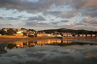
Arnside is a village and civil parish in Cumbria, historically part of Westmorland, near the border with Lancashire, England. The Lake District National Park is located a few miles north. Travelling by road, Arnside is 22 miles (35 km) to the south of Kendal, 25.3 miles (40.7 km) to the east of Ulverston, 35.2 miles (56.6 km) to the east of Barrow-in-Furness, 15.7 miles (25.3 km) to the west of Lancaster and 14.3 miles (23.0 km) to the east of Grange-over-Sands. In the 2001 census the parish had a population of 2,301, increasing at the 2011 census to 2,334.

Haverthwaite is a small village and civil parish in the Furness region of Cumbria, England. It is also within the boundaries of the Lake District National Park. It is located several miles east of Ulverston and is near the southern end of Windermere. In the 2001 census the parish had a population of 728, increasing at the 2011 census to 797.
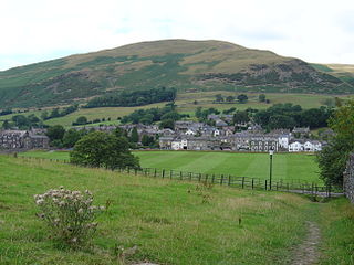
Sedbergh is a town and civil parish in the ceremonial county of Cumbria. It falls within the historic boundaries of the West Riding of Yorkshire. Since April 2023, it is administered by Westmorland and Furness local authority. The 2001 census gave the parish a population of 2,705, increasing at the 2011 census to 2,765. It lies about 10 miles (16 km) east of Kendal, 28 miles (45 km) north of Lancaster and about 10 miles (16 km) north of Kirkby Lonsdale, within the Yorkshire Dales National Park. It stands at the foot of Howgill Fells, on the north bank of the River Rawthey, which joins the River Lune 2 miles (3 km) below the town.

Kirkby-in-Furness, generally referred to simply as Kirkby locally, is a village that is the major part of the parish of Kirkby Ireleth in the Furness district of Cumbria, England. Historically part of Lancashire, it is close to the Lake District National Park. It is about 3 miles (5 km) south of Broughton in Furness, 5 miles (8 km) northwest of Ulverston and 9 miles (14 km) north of Barrow-in-Furness. It is one of the largest villages on the peninsula's north-western coast, looking out over the Duddon estuary. To its east is the SSSI of Kirkby Moor and to its west is the SSSI of Duddon Estuary. The 2021 census showed Kirkby to have a population of 580.

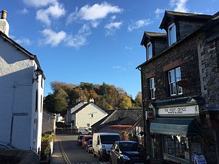
Coniston is a village and civil parish in Westmorland and Furness, Cumbria, England. In the 2001 census the parish had a population of 1,058, decreasing at the 2011 census to 928. Historically part of Lancashire, it is in the southern part of the Lake District National Park, between Coniston Water, the third longest lake in the Lake District, and Coniston Old Man.
Broughton in Furness is a market town in the civil parish of Broughton West in the South Lakeland district of Cumbria, England. It had a population of 529 at the 2011 Census. It is located on the south western boundary of England's Lake District National Park in the Furness region of Cumbria, which was originally part of Lancashire before 1974.

Lindal-in-Furness is a village on the Furness peninsula of Cumbria, England. Historically in Lancashire, it lies eight miles to the north-east of Barrow-in-Furness, on the A590 trunk road. The civil parish is Lindal and Marton which had a population of 755 at the 2011 Census.
Angerton may refer to several places:

Bootle is a village and civil parish in the Borough of Copeland in Cumbria, England. The parish had a population of 745 in the 2001 census, decreasing slightly to 742 at the 2011 census. Historically in Cumberland, the village is in the Lake District National Park, and is close to the Irish Sea coast. Near to Bootle is the Eskmeals Firing Range, which was a large employer but in the mid to late 1990s reduced the workforce. Also within the parish is Hycemoor, a hamlet situated 1.2 miles (1.9 km) north-west of Bootle, where Bootle railway station is located.

Borwick is a village and civil parish in the City of Lancaster district of Lancashire, England, about 8 miles north of Lancaster, on the Lancaster Canal. It is situated just south of the border with Cumbria. The parish of Borwick had a population of 210 recorded in the 2001 census, decreasing to 181 at the 2011 Census.

Seascale is a village and civil parish on the Irish Sea coast of Cumbria, England, historically within Cumberland. The parish had a population of 1,747 in 2001, barely increasing by 0.4% in 2011.
Kirkoswald is a village, civil parish, and former market town located in Westmorland and Furness, England, about 9 miles (14 km) from Penrith. The village is in the historic county of Cumberland. The village, referred to colloquially as KO, had a population of 870 at the 2001 census, which rose to 901 at the 2011 Census.

Askam and Ireleth is a civil parish close to Barrow-in-Furness in Westmorland and Furness, Cumbria, England. Historically part of Lancashire, it originally consisted of two separate coastal villages with different origins and histories which, in recent times, have merged to become one continuous settlement. In the 2001 census the parish had a population of 3,632, reducing at the 2011 census to 3,462.

Kirkby Ireleth is a civil parish in the South Lakeland district of the English county of Cumbria. It includes the villages of Grizebeck and Kirkby-in-Furness - which is really a collection of six different hamlets, namely: Soutergate, Wall End, Beck Side, Sand Side, Marshside and Chapels; and other outlying settlements including Bailiff Ground, Gargreave, Friars' Ground, Beanthwaite, Dove Bank, Dove Ford and Woodland. The parish had a population of 1,247 at the 2001 Census. At the 2011 census Kirkby Ireleth was grouped with Angerton giving a total population of 1,174.

Gilcrux is a small village and civil parish in the ceremonial county of Cumbria, England, and historically part of Cumberland. It is situated just outside the Lake District National Park.

Colton is a village and civil parish in the South Lakeland district of Cumbria, England. In the 2001 census the parish had a population of 765, decreasing at the 2011 census to 672. It was historically part of Lancashire. Its name has been recorded as Coleton and Coulton, and its existence has been recorded as early as 1202.

Holme St Cuthbert is a small village and civil parish in the county of Cumbria, United Kingdom. The village is located approximately 23 miles to the south-west of Carlisle, Cumbria's county town, and was historically in the county of Cumberland.

Staveley-in-Cartmel is a small village and civil parish in South Lakeland district, Cumbria, England. It lies east of Newby Bridge, near the south end of Windermere, 9 miles (14 km) northeast of Ulverston. It is sometimes known as Staveley-in-Furness. Both names distinguish it from another Staveley in Cumbria. In the 2001 census the parish had a population of 428, decreasing at the 2011 census to 405.
Holme East Waver is a civil parish in Cumbria, United Kingdom. It is bordered to the north by the civil parish of Bowness-on-Solway, to the east by the civil parishes of Kirkbride, Woodside, and Waverton, and to the south by the civil parishes of Dundraw and Holme Abbey, lands common to Holme St. Cuthbert, Holme Low, and Holme Abbey, and the town of Silloth-on-Solway. At the 2001 census, it had a population of 306 in 121 households, increasing slightly at the 2011 Census to a population of 318 in 130 households. It is named for the River Waver, and the rivers Waver and Wampool enter the Solway Firth at the western end of the parish. Part of the Solway Coast Area of Outstanding Natural Beauty is within the parish of Holme East Waver. The largest village is Newton Arlosh.


