Animas, New Mexico | |
---|---|
Coordinates: 31°56′56″N108°48′26″W / 31.94889°N 108.80722°W Coordinates: 31°56′56″N108°48′26″W / 31.94889°N 108.80722°W | |
Country | United States |
State | New Mexico |
County | Hidalgo |
Area | |
• Total | 15.66 sq mi (40.57 km2) |
• Land | 15.66 sq mi (40.57 km2) |
• Water | 0.00 sq mi (0.00 km2) |
Elevation | 4,406 ft (1,343 m) |
Population | |
• Total | 180 |
• Density | 11.49/sq mi (4.44/km2) |
Time zone | UTC-7 (Mountain (MST)) |
• Summer (DST) | UTC-6 (MDT) |
ZIP Code | 88020 |
Area code | 575 |
FIPS code | 35-03750 |
GNIS feature ID | 0885759 |
Animas is an unincorporated community and census-designated place (CDP) in west-central Hidalgo County, New Mexico, United States, in the southwestern corner of the state. As of the 2010 census it had a population of 237. [3]
It lies at the intersection of State Roads 9 and 338, at an elevation of 4,406 feet (1,343 m) approximately 30 miles (48 km) south of the city of Lordsburg, the county seat. [4] [5] Although Animas is unincorporated, it has a post office, which opened in 1909, with the ZIP code of 88020. [6] [7]
Founded circa 1753 by the Spanish, [8] Animas became part of the newly independent country of Mexico in 1821. [9] Unlike most of New Mexico, Animas was not part of the Mexican Cession after the Mexican–American War ended; it is located in the area sold to the United States with the Gadsden Purchase of 1853. [10]
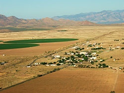
Animas is an isolated ranching community. It is located in the valley bounded by the Peloncillo Mountains on the west and the Pyramid Mountains and Animas Mountains on the east. It is situated just west of the Continental Divide [5] and is approximately 30 miles (48 km) south of Lordsburg, the nearest significant population center. [8] Smaller communities closer to Animas include Cotton City, Playas, and Rodeo. [5] Animas lies in a region rich in Native American history—twenty-one different archeological sites in the Animas area are listed on the National Register of Historic Places. [11]
According to the U.S. Census Bureau, the Animas census-designated place has an area of 15.7 square miles (40.6 km2), all land. [3]
Animas has a cool semi-arid climate (Köppen BSk) with hot summers and mild winters.
Climate data for Animas, New Mexico (1991–2020 normals, extremes 1923–2020) | |||||||||||||
---|---|---|---|---|---|---|---|---|---|---|---|---|---|
Month | Jan | Feb | Mar | Apr | May | Jun | Jul | Aug | Sep | Oct | Nov | Dec | Year |
Record high °F (°C) | 81 (27) | 84 (29) | 92 (33) | 99 (37) | 105 (41) | 110 (43) | 110 (43) | 105 (41) | 107 (42) | 95 (35) | 86 (30) | 80 (27) | 110 (43) |
Mean maximum °F (°C) | 69.9 (21.1) | 74.9 (23.8) | 82.0 (27.8) | 88.4 (31.3) | 96.7 (35.9) | 103.0 (39.4) | 102.3 (39.1) | 98.5 (36.9) | 95.5 (35.3) | 89.4 (31.9) | 78.9 (26.1) | 71.2 (21.8) | 104.1 (40.1) |
Average high °F (°C) | 57.0 (13.9) | 61.9 (16.6) | 69.2 (20.7) | 77.3 (25.2) | 85.8 (29.9) | 94.6 (34.8) | 92.9 (33.8) | 90.1 (32.3) | 86.2 (30.1) | 77.6 (25.3) | 65.9 (18.8) | 56.4 (13.6) | 76.2 (24.6) |
Daily mean °F (°C) | 44.1 (6.7) | 48.1 (8.9) | 54.3 (12.4) | 61.2 (16.2) | 69.7 (20.9) | 78.6 (25.9) | 80.0 (26.7) | 77.9 (25.5) | 73.4 (23.0) | 63.3 (17.4) | 51.9 (11.1) | 43.8 (6.6) | 62.2 (16.8) |
Average low °F (°C) | 31.2 (−0.4) | 34.2 (1.2) | 39.3 (4.1) | 45.0 (7.2) | 53.6 (12.0) | 62.7 (17.1) | 67.2 (19.6) | 65.8 (18.8) | 60.6 (15.9) | 48.9 (9.4) | 38.0 (3.3) | 31.2 (−0.4) | 48.1 (8.9) |
Mean minimum °F (°C) | 17.5 (−8.1) | 20.4 (−6.4) | 25.0 (−3.9) | 30.7 (−0.7) | 39.3 (4.1) | 50.0 (10.0) | 58.0 (14.4) | 56.8 (13.8) | 49.4 (9.7) | 33.0 (0.6) | 21.9 (−5.6) | 17.2 (−8.2) | 14.0 (−10.0) |
Record low °F (°C) | −7 (−22) | 0 (−18) | 7 (−14) | 18 (−8) | 25 (−4) | 37 (3) | 45 (7) | 44 (7) | 33 (1) | 19 (−7) | 4 (−16) | −19 (−28) | −19 (−28) |
Average precipitation inches (mm) | 0.71 (18) | 0.51 (13) | 0.40 (10) | 0.18 (4.6) | 0.20 (5.1) | 0.50 (13) | 2.29 (58) | 1.95 (50) | 1.00 (25) | 0.99 (25) | 0.59 (15) | 1.03 (26) | 10.35 (263) |
Average snowfall inches (cm) | 1.7 (4.3) | 0.5 (1.3) | 0.3 (0.76) | 0.0 (0.0) | 0.0 (0.0) | 0.0 (0.0) | 0.0 (0.0) | 0.0 (0.0) | 0.0 (0.0) | 0.0 (0.0) | 0.2 (0.51) | 0.9 (2.3) | 3.6 (9.1) |
Average precipitation days (≥ 0.01 inch) | 3.8 | 3.8 | 2.5 | 1.1 | 1.5 | 2.8 | 7.7 | 7.6 | 4.4 | 3.4 | 2.3 | 4.1 | 45.0 |
Average snowy days (≥ 0.1 in) | 0.6 | 0.2 | 0.2 | 0.0 | 0.0 | 0.0 | 0.0 | 0.0 | 0.0 | 0.0 | 0.1 | 0.5 | 1.6 |
Source: NOAA [12] [13] |
Census | Pop. | Note | %± |
---|---|---|---|
2020 | 180 | — | |
U.S. Decennial Census [14] [2] |
Hidalgo County is the southernmost county of the U.S. state of New Mexico. As of the 2010 census, the population was 4,894. The county seat and largest city is Lordsburg. A bill creating Hidalgo from the southern part of Grant County was passed on February 25, 1919, taking effect at the beginning of 1920. The county was named for the town north of Mexico City where the Treaty of Guadalupe Hidalgo was signed, which in turn was named for Miguel Hidalgo y Costilla, the priest who is known as the "Father of Mexican Independence." The county is located on the Mexico–United States border.
Playas is a census-designated place (CDP) in Hidalgo County, New Mexico, United States. As of the 2010 census it had a population of 74.
Perkins is a census-designated place and unincorporated community in Jenkins County, Georgia, United States. As of the 2010 census it had a population of 91.
Summersville is a census-designated place (CDP) and unincorporated community in Green County, Kentucky, United States. As of the 2010 census it had a population of 568.
Crescent is an unincorporated community and census-designated place (CDP) in McIntosh County, Georgia, United States. It lies along State Route 99, 12 miles (19 km) north of the city of Darien, the county seat of McIntosh County. Its elevation is 30 feet (9.1 m) above sea level. It has a post office with the ZIP code 31304.
Gallant, also known as Clear Springs or Greasy Cove, is a census-designated place and unincorporated community in Etowah, and St. Clair counties, Alabama, United States. It lies west of the city of Gadsden, the county seat of Etowah County. As of the 2010 census, its population was 855. It has a post office with the ZIP code 35972.
Trenton is an unincorporated community and census-designated place (CDP) in northwestern Williams County, North Dakota, United States. It lies along North Dakota Highway 1804 southwest of the city of Williston, the county seat of Williams County. Its elevation is 1,900 feet (579 m). It has a post office with the ZIP code 58853. The community lies 220 miles north-west of Bismarck. It was first listed as a CDP prior to the 2020 census.
McGregor is an unincorporated community and census-designated place (CDP) in northeastern Williams County, North Dakota, United States. It lies along North Dakota Highway 40, northeast of the city of Williston, the county seat of Williams County. McGregor's elevation is 2,218 feet (676 m). Although unincorporated, it has a post office, with the ZIP code of 58755. It was first listed as a CDP prior to the 2020 census.
Champion is an unincorporated community and census-designated place in central Chase County, Nebraska, United States. As of the 2010 census, it had a population of 103. It has a post office with the ZIP code 69023.
Jensen is a census-designated place in eastern Uintah County, Utah, United States. The population was 412 at the 2010 census. It lies along the Green River and U.S. Route 40, southeast of the city of Vernal, the county seat of Uintah County, and about 17 miles west of the Colorado border. Although Jensen is unincorporated, it has a post office, with the ZIP code of 84035.
Enders is an unincorporated community and census-designated place in Chase County, Nebraska, United States. As of the 2010 census it had a population of 42. Although Enders is unincorporated, it has a post office, with the ZIP code of 69027.
Inland is an unincorporated community and census-designated place in northwestern Clay County, Nebraska, United States. As of the 2010 census it had a population of 62. Although Inland is unincorporated, it has a post office, with the ZIP code of 68954.
Keystone is an unincorporated community and census-designated place in central Keith County, Nebraska, United States. As of the 2010 census its population was 59.
St. Libory is an unincorporated community and census-designated place (CDP) in southeastern Howard County, Nebraska, United States. As of the 2010 census it had a population of 264.
Neal is an unincorporated community in eastern Greenwood County, Kansas, United States. As of the 2020 census, the population of the community and nearby areas was 37. It is located approximately 10 miles east of the city of Eureka along U.S. Route 54 highway.
Salt Rock is a census-designated place (CDP) in southern Cabell County, West Virginia, United States. As of the 2010 census, its population was 388. It lies along West Virginia Route 10 southeast of the city of Huntington, the county seat of Cabell County. Its elevation is 581 feet (177 m). Although Salt Rock is unincorporated, it has a post office, with the ZIP code of 25559. The community most likely was so named on account of there being a small-scale local salt manufacturing industry.
Conroy is an unincorporated community and census-designated place (CDP) in central Iowa County, Iowa, United States. It lies along local roads southeast of the city of Marengo, the county seat of Iowa County. Its elevation is 879 feet (268 m). Conroy has a post office with the ZIP code of 52220, which opened on 5 January 1885. As of the 2010 census the population was 259.
Salt Flat is a ghost town in northeastern Hudspeth County, Texas, United States. It lies along the concurrent U.S. Routes 62 and 180 north of the Census-designated place (CDP) of Sierra Blanca, the county seat of Hudspeth County. Its elevation is 3,730 feet (1,137 m). Although Salt Flat is unincorporated, it has a ZIP Code of 79847. The headquarters of the nearby Guadalupe Mountains National Park uses this ZIP Code although it is located closer to Pine Springs, which has no post office.
Carlsbad is a census-designated place and unincorporated community in northwest Tom Green County, Texas, United States. It lies along U.S. Route 87 northwest of the city of San Angelo, the county seat of Tom Green County. Its elevation is 2,024 feet (617 m). Although Carlsbad is unincorporated, it has a post office, with the ZIP code of 76934; the ZCTA for ZIP Code 76934 had a population of 1,332 at the 2000 census.
Nathalie is an unincorporated community and census-designated place (CDP) in Halifax County, Virginia, United States, in the south-central region of the state. The population as of the 2010 census was 183.
Media related to Animas, New Mexico at Wikimedia Commons