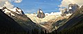
The Bugaboos are a mountain range in the Purcell Mountains of eastern British Columbia, Canada. The granite spires of the group are a popular mountaineering destination. The Bugaboos are protected within Bugaboo Provincial Park.
Snowpatch Spire is a mountain peak in British Columbia, Canada. With its first ascent in 1940, it was the last of the Bugaboo Spires to be climbed. It is located southwest of the Conrad Kain hut, between Bugaboo, Vowell and Crescent Glaciers, at the south end of Bugaboo Provincial Park. The mountain's toponym was officially adopted October 29, 1962, by the Geographical Names Board of Canada.

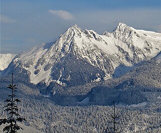
Howser Spire, or Howser Spire Massif, is a group of three distinct granite peaks, and the highest mountain of the Canadian Bugaboo Spires. The mountain is located at the southwest corner of the Vowell Glacier, within the Bugaboo mountain range in the Purcell Mountains, a subrange of British Columbia's Columbia Mountains, The highest of the three spires is the North Tower at 3,412 m (11,194 ft), the Central Tower the lowest, and the South Tower is slightly lower than the North at 3,292 m (10,801 ft).

Hound's Tooth is a peak in the Purcell Mountains of the Columbia Mountains in southeastern British Columbia, Canada. Hound's Tooth is a rock pinnacle at the end of Marmolata Mountain's northeast ridge. Both mountains are Nunataks, sticking up from the middle of the Bugaboo Glacier. The Hounds' Tooth is composed of a coarse, fractured granite.

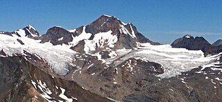
Joffre Peak is a 2,721-metre (8,927-foot) mountain summit located in the Coast Mountains, in Joffre Lakes Provincial Park, in southwestern British Columbia, Canada. It is the second-highest point of the Joffre Group, which is a subset of the Lillooet Ranges. It is situated 26 km (16 mi) east of Pemberton and 11 km (7 mi) northeast of Lillooet Lake. Joffre is more notable for its steep rise above local terrain than for its absolute elevation as topographic relief is significant with the summit rising 1,500 meters (4,920 ft) above Cayoosh Creek in 4 km (2.5 mi). The nearest higher peak is Mount Matier, 1.6 km (1 mi) to the south. The mountain's climate supports the Matier Glacier on the southwest slope, and the Anniversary Glacier on the southeast slope. Precipitation runoff from the peak drains into Joffre Creek and Cayoosh Creek which are both within the Fraser River watershed.
Eyebrow Peak is a prominent 3,362-metre (11,030-foot) glaciated mountain summit located in the Purcell Mountains in southeast British Columbia, Canada. It is the ninth-highest peak in the Purcells. It is situated 28 km (17 mi) south of The Bugaboos, 44 km (27 mi) west of Invermere, 6 km (3.7 mi) north of Mount Monica, and 18 km (11 mi) east of Duncan Lake. Its nearest higher peak is Commander Mountain, 11.4 km (7.1 mi) to the southeast. The first ascent of the mountain was made in 1914 by Edward Warren Harnden, D. Brown, L. Nettleton, and E. Parson via the west slopes. The name Eyebrow Peak came about by Arthur Oliver Wheeler in 1910 when viewing two broad rock scars near the summit, and their arrangement in connection with the surrounding snow created the appearance of enormous eyebrows. However, using the same sightings as Wheeler, Professor Peter Robinson showed that Wheeler actually saw Mount Farnham. Poor weather conditions led to Wheeler's error, and the Eyebrow moniker was then moved to its present location. The mountain's name was officially adopted June 9, 1960, by the Geographical Names Board of Canada.

Otter Mountain is a prominent 2,693-metre (8,835-foot) glaciated summit located in the Coast Mountains of British Columbia, Canada. It is situated 16 kilometers northeast of Stewart, British Columbia, and the nearest higher peak is Mount Pattullo, 25.4 km (15.8 mi) to the north. Otter ranks as the 23rd most topographically prominent summit of Canada. Topographic relief is significant as the summit rises 2,380 meters above Bitter Creek Valley in 5 kilometers. This mountain's toponym was adopted as "Mount Otter" on 24 July 1945, and officially renamed Otter Mountain on 5 November 1953 by the Geographical Names Board of Canada. Precipitation runoff from the mountain drains west into Bitter Creek which is a tributary of the Bear River, or east to Nelson Creek which is part of the Nass River drainage basin, and all ultimately finds its way to the Inside Passage.

Taurus Mountain is a mountain summit located in British Columbia, Canada.
Mount Carr is a 2,590-metre (8,497-foot) mountain summit located in British Columbia, Canada.

Spire Peaks is a 2,279-metre (7,477-foot) mountain located in British Columbia, Canada.
Pyramid Mountain is a 2,158-metre (7,080-foot) summit located in British Columbia, Canada.
Mount Conrad is a 3,279-metre (10,758-foot) mountain summit in British Columbia, Canada.

Howser Peak is a 3,094-metre (10,151-foot) summit in The Bugaboos of British Columbia, Canada. It is located south of the Bugaboo Glacier and is the southernmost point of Bugaboo Provincial Park. Precipitation runoff from Howser Peak drains north into Bugaboo Creek which is a tributary of the Columbia River; as well as south to Duncan River via Howser Creek. Howser Peak is more notable for its steep rise above local terrain than for its absolute elevation as topographic relief is significant with the south aspect rising 1,380 meters (4,527 ft) in 2.5 km (1.6 mi).

Flattop Peak is a 3,063-metre (10,049-foot) summit in British Columbia, Canada.

Northpost Spire is a 2,911-metre (9,551-foot) peak in British Columbia, Canada.

Wallace Peak is a 2,940-metre (9,650-foot) summit in British Columbia, Canada.
Sentinel Peak is a 2,992-metre (9,816-foot) mountain in British Columbia, Canada.

Serendipity Spire is a 2,857-metre (9,373-foot) mountain in British Columbia, Canada.

Spearmint Spire is a 6,750-foot-elevation (2,057-meter) summit in Alaska, United States.

Doublemint Peak is a 6,372-foot-elevation (1,942-meter) summit in Alaska, United States.