Apethorpe

Last updated

Apethorpe
Manor House gardens, Apethorpe.jpg
Manor House gardens, Apethorpe
Northamptonshire UK location map (2021).svg
Red pog.svg
Apethorpe
Location within Northamptonshire
Population160 (2011)
OS grid reference TL023957
  London 75 miles (120.7 km)
District
Shire county
Region
Country England
Sovereign state United Kingdom
Post town PETERBOROUGH
Postcode district PE8
Dialling code 01780
Police Northamptonshire
Fire Northamptonshire
Ambulance East Midlands
UK Parliament
List of places
UK
England
Northamptonshire
52°32′59″N0°29′29″W / 52.5497°N 0.4913°W / 52.5497; -0.4913

Apethorpe (pronounced "Ap-thorp") is a village, civil parish, [1] former manor and ecclesiastical parish in Northamptonshire, England (in the North Northamptonshire district), situated 11 miles west of the City of Peterborough. The 2001 census records a population of 130, [1] increasing to 160 at the 2011 census. [2] The manor of Apethorpe is recorded in the Domesday Book of 1086 as Patorp. The village is compact, uniform and centred on Main Street. In the late 15th century the manor of Apethorpe was acquired by Sir Guy Wolston, an officer in the household of King Edward IV, who began the construction of the surviving Apethorpe Palace.

Contents

The villages name means 'Api's outlying farm/settlement'. [3]

Location

The village is approximately 6 miles (9.7 km) north of the Northamptonshire market town of Oundle, 12 miles (19.3 km) northeast of Corby, and 11 miles (17.7 km) west of Peterborough. The nearest railway stations are in Corby for London St Pancras and Peterborough for London King's Cross. London is about 75 miles (121 km) via the A1 road.

Features

Church

St Leonard's Church, Apethorpe is mostly Perpendicular but has a chapel of 1621 [4] and tower partly 1633. There is a huge monument to Sir Anthony Mildmay (d.11 September 1617) and another smaller one to Sir Richard Dalton (d.1442). Mildmay was the eldest son of Sir Walter Mildmay, an English statesman who served as Chancellor of the Exchequer of England under Queen Elizabeth I and also founded Emmanuel College, Cambridge. Sir Anthony inherited the family estate and was knighted in 1596 when he was appointed ambassador to Henry IV of France.

Apethorpe Palace

The Willow Brook bounds the eastern edge of the village, which contains the Grade I listed historical monument of Apethorpe Palace owned by the Baron von Pfetten since 2014. [5]

The Willow and Brook

In 1904 Leonard Brassey made many alterations to the village, a number of cottages were built and the old Westmorland Arms was replaced by a new public house, The King's Head. [6] The Pub is now owned by Baron Von Pfetten.

Other structures

Stocks and Whipping Post Stocks and Whipping Post - geograph.org.uk - 45153.jpg
Stocks and Whipping Post

There is a stocks and whipping post just west of the church. The Dovecote on the palace ground is 18th century listed as Scheduled Monument. Pevsner also mentioned Blue Field Farm 0.5 miles (1 km) northeast as having an interesting barn with a cross-cartway through it. [4]

Roman villa

The remains of the villa lie about 500 yards (450m) southeast of the palace and were excavated in 1859. [4] A courtyard of ca. 230 by 240 feet contained the main buildings. The main block on the north side had hypocausts and fine geometric mosaics with two other wings and a bath block. Slate from Collyweston was used for the roofs. Pottery found included terra sigillata and Castor ware. Coins located the main period of use as the 4th century AD. [4] There was a well in the centre of the courtyard. Two small un-inscribed house-altars were found. One coin of Septimius Severus, the remainder Constantinian (?), possibly indicating the date of the main phase of the villa. In successive phases of building there appears to have been at least one aisled building in the same position relative to a winged corridor house at Ickleton. The villa combines a dwelling house with an aisled house. [7]

Notable former residents

The village was home to the actor Rowan Atkinson. [8]

Related Research Articles

<span class="mw-page-title-main">Turweston</span> Human settlement in England

Turweston is a village and civil parish in north-west Buckinghamshire, England. The village is beside the River Great Ouse, which bounds the parish to the north, west and south. Turweston is the most northwesterly parish in Buckinghamshire: the Ouse here forms the county boundary with Northamptonshire to the north and west and Oxfordshire to the south. Across the river, the Northamptonshire market town of Brackley is just west of Turweston, with the town centre about 1 mile (1.6 km) west of the village. The parish has an area of 1,295 acres (524 ha) and had a population of 211 at the 2011 Census.

<span class="mw-page-title-main">Charwelton</span> Human settlement in England

Charwelton is a village and civil parish about 5 miles (8 km) south of Daventry in Northamptonshire, England. The 2011 Census recorded the parish's population as 220.

Longthorpe is an area of the city of Peterborough, in the ceremonial county of Cambridgeshire, England. Located two miles (3.2 km) west from the city centre, the area covers 1,390 acres. For electoral purposes it forms part of Peterborough West ward.

<span class="mw-page-title-main">Thorpe Mandeville</span> Human settlement in England

Thorpe Mandeville is a village and civil parish in West Northamptonshire, England about 6 miles (10 km) northeast of Banbury in neighbouring Oxfordshire. The hamlet of Lower Thorpe is just north of the village.

<span class="mw-page-title-main">Barnwell, Northamptonshire</span> Human settlement in England

Barnwell is a village in North Northamptonshire in England, 2 miles (3.2 km) south of the town of Oundle, 78 miles (126 km) north of London and 14 miles (22.5 km) south-west of Peterborough. The River Nene runs north of the village, separating it from Oundle.

<span class="mw-page-title-main">King's Sutton</span> Human settlement in England

King's Sutton is a village and civil parish in West Northamptonshire, Northamptonshire, England in the valley of the River Cherwell. The village is about 4.1 miles (6.6 km) south-east of Banbury, Oxfordshire.

<span class="mw-page-title-main">Sulgrave</span> Human settlement in England

Sulgrave is a village and civil parish in West Northamptonshire, England, about 5 miles (8 km) north of Brackley. The village is just south of a stream that rises in the parish and flows east to join the River Tove, a tributary of the Great Ouse.

<span class="mw-page-title-main">Ambrosden</span> Human settlement in England

Ambrosden is a village and civil parish in Cherwell, Oxfordshire, England, 3 miles (5 km) southwest of Bicester to which it is linked by the A41 road, and 13 miles (21 km) from Oxford. The 2011 Census recorded the parish's population as 2,248. The parish is bounded by the River Ray to the south, its tributary the River Bure to the west, the outskirts of Bicester to the north and field boundaries to the east.

<span class="mw-page-title-main">Eydon</span> Human settlement in England

Eydon is a village and civil parish in West Northamptonshire, about 8 miles (13 km) north-east of Banbury. The village is between 510 and 540 feet (160 m) above sea level on the east side of a hill, which rises to 580 feet (180 m) and is the highest point in the parish. The parish is bounded to the west by the River Cherwell, to the south by a stream that is one of its tributaries, and to the east and north by field boundaries.

<span class="mw-page-title-main">Ashley, Northamptonshire</span> Human settlement in England

Ashley is a village and civil parish in North Northamptonshire, England, about 4 miles (6.4 km) northeast of Market Harborough, Leicestershire and 5 miles (8.0 km) west of Corby. The population of the civil parish at the 2011 Census was 224, an increase from 217 at the 2001 Census. The village is near the River Welland, which forms the border with Leicestershire. The Roman road called Via Devana in the part from Ratae to Duroliponte ran just north of the village.

<span class="mw-page-title-main">Thenford</span> Human settlement in England

Thenford is a village and civil parish about 5 miles (8 km) northwest of the market town of Brackley in West Northamptonshire, England, and 4 miles (6.4 km) east of Banbury in nearby Oxfordshire. The 2001 Census recorded the parish population as 74. At the 2011 Census the population of the village remained less than 100 and is included in the civil parish of Middleton Cheney.

<span class="mw-page-title-main">King's Cliffe</span> Human settlement in England

King's Cliffe is a village and civil parish on Willow Brook, a tributary of the River Nene, about 9 miles (14 km) northeast of Corby in North Northamptonshire. The parish adjoins the county boundary with the City of Peterborough and the village is about 12 miles (19 km) west of the city centre. The village is not far from the boundary with Lincolnshire and about 6 miles (10 km) south of Stamford.

<span class="mw-page-title-main">Wadenhoe</span> Village in Northamptonshire, England

Wadenhoe is a village and civil parish in North Northamptonshire. The population of the civil parish at the 2011 Census was 244. It is on the River Nene, approximately 4 miles from Thrapston and 10 miles from Corby. The Nene Way long-distance footpath passes through the village.

<span class="mw-page-title-main">Hinton-in-the-Hedges</span> Human settlement in England

Hinton-in-the-Hedges is a small village and civil parish in West Northamptonshire, England, two miles due west of the town of Brackley. West of the village is Hinton-in-the-Hedges Airfield. At the time of the 2001 census, the parish's population was 179 people. It had decreased to 167 at the 2011 Census.
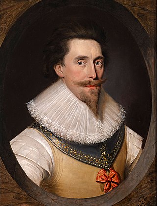
<span class="mw-page-title-main">Apethorpe Palace</span> Country house in Apethorpe, Northamptonshire

Apethorpe Palace, formerly known as "Apethorpe Hall", is a Grade I listed country house, dating to the 15th century, close to Apethorpe, Northamptonshire. It was a "favourite royal residence" for James I.

<span class="mw-page-title-main">East Carlton</span> Human settlement in England

East Carlton is a village and civil parish in the county of Northamptonshire, on the southern ridge overlooking the Welland valley to the north and covers 1,645 acres (666 ha) on a long strip of land. It is 2 miles (3.2 km) west of the town of Corby and is administered as part of North Northamptonshire but was previously in the Corby borough until 2021. At the time of the 2001 census, the parish's population was 270, reducing to 259 at the 2011 census. East Carlton is one of the Thankful Villages that suffered no fatalities during World War I. Although in Northamptonshire, the village is in the Leicestershire LE16 postcode area.

<span class="mw-page-title-main">Rushton, Northamptonshire</span> Human settlement in England

Rushton is a village and civil parish in Northamptonshire. It is about 2 miles (3.2 km) north-east of Rothwell and 3 miles (4.8 km) north-west of Kettering. The parish covers 3,200 acres (1,300 ha) and is situated on both sides of the River Ise. It contains the sites of three deserted settlements, details of which are set out below.

<span class="mw-page-title-main">Chesterton, Oxfordshire</span> Human settlement in England

Chesterton is a village and civil parish on Gagle Brook, a tributary of the Langford Brook in north Oxfordshire. The village is about 1+12 miles (2.4 km) southwest of the market town of Bicester. The village has sometimes been called Great Chesterton to distinguish it from the hamlet of Little Chesterton, about 34 mile (1.2 km) to the south in the same parish. The 2011 Census recorded the parish population as 850.

<span class="mw-page-title-main">St Leonard's Church, Apethorpe</span> Church in Northamptonshire, England

St Leonard's Church is an Anglican church in the village of Apethorpe in Northamptonshire, England. It is an active parish church in the Diocese of Peterborough. It has been designated a Grade I listed building by English Heritage.

<span class="mw-page-title-main">Edward Browning</span> English architect

Edward Browning was an English architect working in Stamford.

References

  1. 1 2 Office for National Statistics: Apethorpe CP. Retrieved 3 November 2009
  2. "Civil Parish population 2011". Neighbourhood Statistics. Office for National Statistics. Retrieved 27 June 2016.
  3. "Key to English Place-names".
  4. 1 2 3 4 Pevsner, Nikolaus (1961). The Buildings of England Northamptonshire. London and New Haven: Yale University Press. pp. 208–9. ISBN   978-0-300-09632-3.
  5. Streetmap.co.uk Archived 23 October 2012 at the Wayback Machine . Retrieved 3 November 2009
  6. www.kingsheadapethorpe.co.uk - About The Kings Head Archived 21 March 2012 at the Wayback Machine - About The Kings Head
  7. On-line archaeology Archived 28 February 2012 at the Wayback Machine , retrieved 1 January 2010
  8. Mikhailova, Anna (25 January 2009). "Is it worth it?" via www.thetimes.co.uk.