The TT Grandstand including the startline, pit lane, re-fuellers, merchandising and scoreboard for the Isle of Man TT and Manx Grand Prix races is situated on the A2 Glencrutchery Road, in the town of Douglas, Isle of Man.
The International Isle of Man TT races are an annual motorcycle sport event run on the Isle of Man in May/June of most years since its inaugural race in 1907, and is often called one of the most dangerous racing events in the world.
Douglas is the capital and largest town of the Isle of Man, with a population of 27,938 (2011). It is located at the mouth of the River Douglas, and on a sweeping bay of two miles. The River Douglas forms part of the town's harbour and main commercial port.
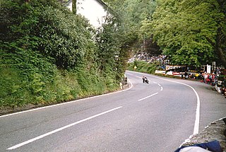
Appledene was part of the Four Inch Course used for the Tourist Trophy car races held between 1905 and 1922, and part of the course used for 1905 International Motor-Cycle Cup Races. It is part of the Mountain Course used since 1911 for the TT from 1923 for the Manx Grand Prix races.
The Four Inch Course was a road-racing circuit first used for the 1908 Tourist Trophy Race for cars, held on public roads closed for racing by an Act of Tynwald. The name of the course derives from the regulations for the 1908 Tourist Trophy adopted by the Royal Automobile Club, which limited the competitors' engines to a cylinder-diameter of four inches. The Four-Inch Course was adopted by the Auto-Cycle Club for the 1911 Isle of Man TT Races. The Four-Inch Course was subsequently known as the Snaefell Mountain Course or Mountain Course when used for motor-cycle racing.
The International Tourist Trophy is an award given by the Royal Automobile Club (RAC) and awarded semi-annually to the winners of a selected motor racing event each year in the United Kingdom. It was first awarded in 1905 and continues to be awarded to this day, making it the longest lasting continually-awarded trophy in motorsports. Tourist Trophy events have been part of major national and international racing series, including the World Sportscar Championship, World Touring Car Championship, European Touring Car Championship, FIA GT Championship, and British Touring Car Championship. It has been awarded to races within a championship, and as a standalone event on various occasions. From 2013, It was announced that the Tourist Trophy would be awarded as part of the 6 Hours of Silverstone in the FIA World Endurance Championship, the first time it has been awarded as part of a sportscar world championship since 1964.
The Manx Grand Prix motorcycle races are held on the Isle of Man TT Course every year for a two-week period, usually spanning the end of August and early September.
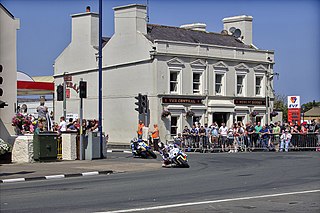
Before the start of racing for the 1953 Manx Grand Prix, the cottage at Appledene corner on the A1 road was demolished.[1]
Robert Steven 'Hizzy' Hislop was a Scottish motorcycle racer. Hislop won at the Isle of Man TT eleven times, won the British 250cc Championship (1990) and British Superbike championship.
A geographic coordinate system is a coordinate system that enables every location on Earth to be specified by a set of numbers, letters or symbols. The coordinates are often chosen such that one of the numbers represents a vertical position and two or three of the numbers represent a horizontal position; alternatively, a geographic position may be expressed in a combined three-dimensional Cartesian vector. A common choice of coordinates is latitude, longitude and elevation. To specify a location on a plane requires a map projection.
This page is based on this Wikipedia article Text is available under the CC BY-SA 4.0 license; additional terms may apply. Images, videos and audio are available under their respective licenses.
Related Research Articles
The Isle of Man TT Mountain Course or TT Course is a motor-cycle road- racing circuit located in the Isle of Man. The motor-cycle TT Course is used principally for the Isle of Man TT Races and also the separate event of the Isle of Man Festival of Motorcycling for the Manx Grand Prix and Classic TT Races held in September of each year. The start-line for the Isle of Man TT Mountain Course is located on Glencrutchery Road in the town of Douglas, Isle of Man.
Handley's Corner is situated just before the 12th Milestone road-side marker, measured from the startline at the TT Grandstand, on the Snaefell Mountain Course used for the Isle of Man TT races on the primary A3 road, in the parish of Michael, in the Isle of Man.
Governor's Bridge is a hairpin bend adjacent to a road junction on the primary A18 Mountain Road in the parish of Onchan in the Isle of Man, with a sudden drop in elevation leading to Governor's Dip, followed by a left-hand bend and finally a right exiting on to the main Glencrutchery Road.
Parliament Square, Ramsey is situated between the 23rd and 24th Milestone road-side markers on the Snaefell Mountain Course used for the Isle of Man TT Races on the junction of the primary A3 Castletown to Ramsey road, the A9 Ramsey to Andreas road and A2 Douglas to Ramsey road situated in the town of Ramsey in the parish of Lezayre in the Isle of Man.
School House Corner is a left curve on the primary A3 Lezayre Road in Ramsey, Isle of Man.
Ramsey Hairpin
is a point on the Snaefell Mountain Course used for the Isle of Man TT races on the Snaefell Mountain Road, designated as A18, in the parish of Maughold in the Isle of Man.
Rhencullen including Birkin's Bend is situated between the 15th and 16th Milestone road-side markers on the Snaefell Mountain Course between Kirk Michael Village and Bishopscourt on the primary A3 Castletown to Ramsey road with side-road junction of the tertiary C19 Orrisdale Loop road in the parish of Michael, Isle of Man.
Brandish Corner is situated between the 35th and 36th Milestone road-side markers on the Snaefell Mountain Course on the primary A18 Mountain Road in the parish of Onchan in the Isle of Man. The road was re-engineered in recent years.
The Bungalow, Isle of Man, one of a handful of better-known vantage points spread around the Snaefell Mountain Course, is situated adjacent to the 31st Milestone roadside marker on the road junction of the primary A18 Mountain Road, the A14 Sulby Glen Road and the road-tramway crossing for the Snaefell Mountain Railway in the parish of Lezayre in the Isle of Man.
Ballacraine, also known as Ballacraine Corner, is one of the named corners of the Snaefell Mountain Course, the motorcycle racing course of the Isle of Man TT and Manx Grand Prix.
Hillberry Corner is situated at the 36th Milestone road-side marker on the Snaefell Mountain Course, being on the primary A18 Mountain Road with the side-road junction of the C22 Little Mill Road, in the parish of Onchan in the Isle of Man.
Gob-ny-Geay is situated at the 35th Milestone on the Snaefell Mountain Course on the primary A18 Mountain Road in the parish of Onchan in the Isle of Man.
Greeba Bridge is situated between the 6 and 7 road-side mile markers on the Snaefell Mountain Course used for the Isle of Man TT races on the junction of the primary A1 Douglas to Peel road and the Greeba Mill Road in the Isle of Man parish of German.
Gorse Lea section of road is situated between the 7th Milestone and 8th Milestone road-side marker on the Snaefell Mountain Course used for the Isle of Man TT Races on the primary A1 Douglas to Peel road in the parish of German in the Isle of Man.
Ballagarraghyn is situated between the 7th and 8th Milestone road-side markers on the Snaefell Mountain Course used for the Isle of Man TT races on the primary A1 Douglas to Peel road in the parish of German in the Isle of Man.
Doran's Bend is situated between the 7th and 8th Milestone road-side markers on the Snaefell Mountain Course used for the Isle of Man TT Races on the primary A3 Castletown to Ramsey road in the parish of German in the Isle of Man.
Glen Helen an area of wooded valleys, is known for the sweeping left-bend and uphill exit towards Creg Willey's Hill on the Snaefell Mountain Course used for the Isle of Man TT Races.
Ballaugh Bridge,, is a hump-backed road bridge over a stream situated between the 17th and 18th Milestone road-side markers on the Snaefell Mountain Course in Ballaugh village, on the primary A3 Castletown-to-Ramsey road and adjacent side junctions with the A10 Ballaugh-to-Ramsey coast road and the tertiary C37 Ballaugh Glen Road in the parish of Ballaugh in the Isle of Man.
Cronk-ny-Mona is situated between the 36 and 37 mile markers used for the Snaefell Mountain Course, being on the primary A18 Mountain Road at the road junction with the A21 Johnny Watterson('s) Lane and the tertiary C10 Scholag Road in the Isle of Man parish of Onchan.
The Nook is situated on the primary A18 Mountain Road in the parish of Onchan in the Isle of Man between the 37th Milestone road-side marker on the Snaefell Mountain Course and the TT Grandstand on the primary A2 Glencrutchery Road in the town of Douglas.