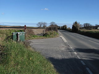
Glen Duff (Manx: black glen)[1] is situated adjacent to the 23rd road milestone on the A3Castletown to Ramsey road with the junction with the B14 Bernaharra Road (Road of the Ayre) in the parish of Kirk Christ Lezayre in the Isle of Man.[2]
The Engineering Work Section, Highways Division of the Isle of Man Department of Infrastructure has its northern depot at Glen Duff Quarry, including a domed storage barn built in 2003 known as the 'Igloo', for storage of road salt treatments during the winter.[3] The previous Isle of Man Highway and Transport Board Glen Duff depot was damaged by fire in a works highway garage in 1953.[4]
The Glen Duff Depot and Glen Duff old quarry (previously known as Manx: Gob-y-Vuinney)[5][6] has been identified within the Ancient Woodland Inventory by the Manx Wildlife Trust. Within the 2.57 hectares (6.4 acres) site, the Trust observed hazel (Corylus avellana), oak (Quercus × rosacea) and silver birch (Betula pendula) trees along with wild strawberry (Fragaria vesca) within the depot and old quarry.[7]
Motor-Sport heritage
Glen Duff was part of the 37.50 Mile Four Inch Course for the RAC Tourist Trophy automobile races held in the Isle of Man between 1908 and 1922.[8]
In 1911, the Four Inch Course for automobiles was first used by the Auto-Cycling Union for the Isle of Man TT motorcycle races.[9] This included Glen Duff[10] and Glentramman section and the course later became known as the 37.73 mile Isle of Man TT Mountain Course which has been used since 1911 for the Isle of Man TT Races and from 1923 for the Manx Grand Prix races.[11]
↑ Oak/Hazel Woodlands of the Isle of Man Part II Page 5-7 Ancient Woodland Inventory 3 GLEN DUFF Andree Dubbeldam Manx Wildlife Trust (2011) Wildflowers of Mann Project
↑ TT Pioneers – Early Car Racing in the Isle of Man page 22 Robert Kelly, Mercury Asset Management (1996)(1st Edition) The Manx Experience, The Alden Press ISBN No 1 873120 61 3
↑ Round the TT Course with Harold Daniell R.R. Holliday Motor Cycling (c1947) Castrol Oils That Lap at 91! Harold L.Daniell, TT Record Holder. Tells How it was done.
↑ TT Special page 31 edited by G.S. Davison Wednesday 6 June 1956
↑ The History of the Manx Grand Prix page 7, 8, 9 by Bill Snelling Amulree Publishing(1998) Manx Heritage Foundation ISBN1 901508 04 8
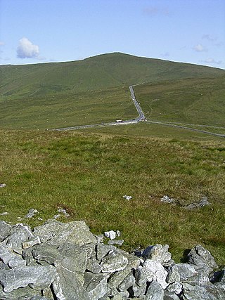
Snaefell – is the highest mountain and the only summit above 2,000 feet (610 m) on the Isle of Man, at 2,037 feet (620.9 m) above sea level. The summit is crowned by a railway station, cafe and several communications masts.
The Point of Ayre is the northernmost point of the Isle of Man. It lies at the northern end of Ramsey Bay 6 miles (10 km) north of the town of Ramsey. The point can be accessed by the A16 road from Bride. Point of Ayre lighthouse, the oldest lighthouse on the Isle of Man, is located here.
Foxdale is a village consisting of the districts of Upper and Lower Foxdale on the A3 Castletown to Ramsey Road with the junction of the A24 Foxdale to Braaid road and the A40 The Hope road in the parish of Kirk Patrick in the Isle of Man.
Sulby is a village in the Isle of Man. It is 4 miles from Ramsey and is located in the parish of Kirk Christ Lezayre on the A3 Castletown road.
Barregarrow is a district in the Isle of Man. It is a hilly area and is part of the Isle of Man TT motorcycle race course.
Crosby is a small village located 3+3⁄4 miles west of Douglas in the parish of Marown in the Isle of Man.
Rhencullen including Birkin's Bend is adjacent to the 17th milestone of the TT course, on the primary A3 Castletown to Ramsey road in the Isle of Man.
Laurel Bank is situated between the 10th Milestone and 11th Milestone road-side markers on the primary A3 Castletown to Ramsey Road between Ballacraine and Glen Helen in the parish of Kirk German in the Isle of Man.
Brandywell, Isle of Man or is an area of Mountain Lands of heath moorland and coniferous woodland plantations situated in the Northern Upland Massif in the parish of Kirk Michael in the Isle of Man. The area was previously used by local shepherds due to a local stream and a nearby former venerated water well which was known for its distinctive quality and "brandy" colour of the water.
Kate's Cottage, Isle of Man is a cottage and one of the named corners of the Snaefell Mountain Course used in Grand Prix-style motorcycle racing along public roadways of the Isle of Man. It has been asserted in the Isle of Man's program of Registered Buildings that the cottage was built by 1869.
Sarah's Cottage is situated between the 11th milestone and 12th milestones on Creg Willey’s Hill on the primary A3 Castletown to Ramsey Road in the parish of Kirk German in the Isle of Man.
Greeba Bridge is situated between the 6th milestone and 7th road milestones on the primary A1 Douglas to Peel road and the junction with the Greeba Mill Road in the parish of Kirk German in the Isle of Man.
Ballagarraghyn is a farm situated between the 7th milestone and 8th Milestone road-side markers on the primary A1 Douglas to Peel road in the parish of German in the Isle of Man.
Glen Helen or Lambfell Glen) is one of a series of eighteen Manx National Glens owned and maintained by the Forestry Amenity and Lands Directorate of the Isle of Man Department of Environment, Food and Agriculture.
Cronk Urleigh is a stretch of road situated at the 15th Milestone on the primary A3 Castletown to Ramsey in the parish of Kirk Michael in the Isle of Man.
North Barrule is the second highest peak in the Isle of Man at 565 metres (1,854 ft). From the summit the northern plain of the Isle of Man can be viewed along with the coastlines of Ireland, Cumbria, Wales and Scotland.
Orrisdale North is situated adjacent the 16th TT Milestone on the primary A3 Castletown to Ramsey road with the nearby junction with the tertiary C19 Orrisdale Loop Road and D13 Bollyn Road in the parish of Ballaugh in the Isle of Man.
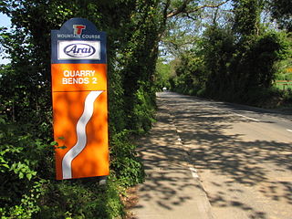
Quarry Bends is situated adjacent to the 20th Milestone road-side marker on the primary A3 Castletown to Ramsey, in the parishes of Ballaugh and Kirk Christ Lezayre in the Isle of Man.
Ballagarey is located between the third and fourth milemarkers used for recognition of the Snaefell Mountain Course road-racing circuit on the primary A1 Douglas to Peel road, in the parish of Marown in the Isle of Man.
Beinn-y-Phott, is a peak of 546 metres on the Isle of Man, about 2 km SW of Snaefell.
This page is based on this Wikipedia article Text is available under the CC BY-SA 4.0 license; additional terms may apply. Images, videos and audio are available under their respective licenses.