Signpost Corner, Isle of Man is a former temporary motor-cycle race signal station, located on the A18 Snaefell Mountain Road at the road junction with the A39 Hillberry Road / B11 Avondale Road in the parish of Onchan in the Isle of Man.
The name derives from a signal station for the Isle of Man TT races and Manx Grand Prix. The signal station at Signpost Corner was connected to the race scoreboards located in Glencrutchery Road in Douglas by a telephone land-line. Race officials would instruct local Scouts on the scoreboards to switch a light on above an individual competitor's scoreboard which would indicate to the pit crew and race officials that a particular rider had passed through Signpost Corner and might shortly be pulling into the race-pits located at the Grandstand on Glencrutchery Road to refuel.[1]
Bedstead Corner
Located near the former signal station at the Signpost road junction is Bedstead Corner on the (A18) Bemahague Road section of the Isle of Man TT Mountain Course. The name is said to have come from a section of farm walling which had fallen into disrepair. The landowner was said to have made 'temporary' repairs with old bedsteads in order to make the field stockproof. The 'temporary' repairs remained in place long enough for the name to become established and stick until the present day.
Popular culture
George MacDonald Fraser, author of the Flashman series of books, lived on the Isle of Man and titled his 2002 autobiographical memoir of his experiences as a Hollywood scriptwriter as "The Light's On at Signpost".[2]
Motor sport heritage
In 1911 the Four Inch Course for automobiles was first used by the Auto-Cycling Union for the Isle of Man TT motorcycle races.[3]
The section of the Mountain Course from the Cronk-ny-Mona road junction to Governor's Bridge was first adopted for the 1920 Isle of Man TT motor-cycle races and the Manx Grand Prix in 1923.[4] This included the Signpost Corner road junction, ‘Bedstead Corner’ and the section known as the "old road" of the TT Course from the Nook to Governor's Bridge.
The Signpost Corner section of the TT Course is used as part of timed special stages for the former Manx International Rally and Rally Isle of Man.
In recent years the race signal station has been moved to a preceding[clarification needed] position on the Mountain Course at Cronk-ny-Mona as average race speeds have increased.[5]
Road improvements
The section of the TT Course between Signpost Corner and Bedstead Corner was widened during the winter of 1953/54 and the road re-profiled.[6]
Sources
↑ Isle of Man TT by Charles Deane pages 10–11 (1st Edition)(1975) Patrick Stevens Ltd ISBN0-85059-172-4
↑ The Light's On at Signpost: Memories of the Movies, Among Other Matters by George MacDonald Fraser Foreword Harper Collins (2002) ISBN0007136471
↑ Round the TT Course with Harold Daniell R.R. Holliday Motor Cycling (c1947) Castrol Oils That Lap at 91! Harold L.Daniell, TT Record Holder. Tells How it was done.
↑ The History of the Manx Grand Prix page 7, 8, 9 by Bill Snelling Amulree Publishing(1998) Manx Heritage Foundation ISBN1 901508 04 8
↑ TT News Report 1 page 2 Isle of Man Newspapers Ltd (2006) Johnson Press Publishing Ltd
The Isle of Man TT or Tourist Trophy races are an annual motorcycle racing event run on the Isle of Man in May and June of most years since its inaugural race in 1907. The event begins on the UK Spring Bank Holiday at the end of May and runs for thirteen days. It is often called one of the most dangerous racing events in the world as many competitors have died.
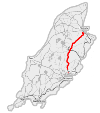
The A18 Snaefell Mountain Road or Mountain Road is a primary main A-road of 13.35 miles (21.48 km) in length which connects the towns of Douglas and Ramsey in the Isle of Man.
The Isle of Man TT Mountain Course or TT Course is a street and public rural road circuit located in the Isle of Man, used for motorcycle racing. The motorcycle TT Course is used principally for the Isle of Man TT Races and also the separate event of the Isle of Man Festival of Motorcycling for the Manx Grand Prix and Classic TT Races held in September of each year. The start-line for the Isle of Man TT Mountain Course is located on Glencrutchery Road in the town of Douglas, Isle of Man.
The Clypse Course describes a motor-cycle racing course used for the Isle of Man TT Races between 1954 and 1959.
26th Milestone, Isle of Man is situated on the primary A18 Snaefell Mountain Road in the parish of Lezayre in the Isle of Man. At the 26th Milestone racing marker used for the Isle of Man TT Races and Manx Grand Prix, the bend was named in honour of 26-times TT winner Joey Dunlop who died after a racing motorcycle crash in Estonia in July 2000. The area is the location of the only accident in which spectators at the Isle of Man TT races or Manx Grand Prix have been killed in a motorcycle racing accident.
Creg-ny-Baa is located between the 3rd Milestone and 4th Milestone of the primary A18 Snaefell Mountain Road and the road junction with the secondary B12 'Creg-ny-Baa Back-Road', in the parish of Kirk Onchan in the Isle of Man.
Guthrie's Memorial is a S-bend corner between the 26 and 27 mile road-side markers on the primary A18 Snaefell mountain road, part of the Snaefell Mountain Course known mainly for motorcycle racing, situated in the Isle of Man parish of Lezayre.
The TT Grandstand including the startline, pit lane, re-fuellers, merchandising, scoreboard and paddocks for the Isle of Man TT and Manx Grand Prix races is situated on the A2 Glencrutchery Road, in the town of Douglas, Isle of Man.
St Ninian's Crossroads is situated between the TT Grandstand and the 1st Milestone road-side marker on the Snaefell Mountain Course on the primary A2 Douglas to Ramsey road in the town of Douglas in the Isle of Man.
Governor's Bridge is a hairpin bend adjacent to a road junction on the primary A18 Mountain Road in the parish of Onchan in the Isle of Man, with a sudden drop in elevation leading to Governor's Dip, followed by a left-hand bend and finally a right exiting on to the main Glencrutchery Road.
Gooseneck, Isle of Man, is an acute uphill right-bend on the Snaefell Mountain Course used for the TT motorcycle races between the 25th and 26th Milestone racing road-side markers, on the 37+ mile circuitous-course, measured from the startline at the TT Grandstand.
The Four Inch Course was a road-racing circuit first used for the 1908 Tourist Trophy Race for cars, held on public roads closed for racing by an Act of Tynwald. The name of the course derives from the regulations for the 1908 Tourist Trophy adopted by the Royal Automobile Club, which limited the competitors' engines to a cylinder-diameter of four inches. The Four-Inch Course was adopted by the Auto-Cycle Club for the 1911 Isle of Man TT Races. The Four-Inch Course was subsequently known as the Snaefell Mountain Course or Mountain Course when used for motor-cycle racing.
Laurel Bank is situated between the 10th Milestone and 11th Milestone road-side markers on the primary A3 Castletown to Ramsey Road between Ballacraine and Glen Helen in the parish of Kirk German in the Isle of Man.
Brandywell, Isle of Man or is an area of Mountain Lands of heath moorland and coniferous woodland plantations situated in the Northern Upland Massif in the parish of Kirk Michael in the Isle of Man. The area was previously used by local shepherds due to a local stream and a nearby former venerated water well which was known for its distinctive quality and "brandy" colour of the water.
Kate's Cottage, Isle of Man is a cottage and one of the named corners of the Snaefell Mountain Course used in Grand Prix-style motorcycle racing along public roadways of the Isle of Man. It has been asserted in the Isle of Man's program of Registered Buildings that the cottage was built by 1869.
Sarah's Cottage is situated between the 11th milestone and 12th milestones on Creg Willey’s Hill on the primary A3 Castletown to Ramsey Road in the parish of Kirk German in the Isle of Man.
Ballacraine is located between the 7th and 8th milestones of the TT course, at the junction of the A1 Douglas to Peel and A3 Castletown to Ramsey primary roads in the parish of German in the Isle of Man. It is now at the east end of the ribbon development of St. John's village. At the junction is the former public house, the Ballacraine Inn, now a private residence.
Hillberry Corner is situated at the 36th Milestone road-side marker on the Snaefell Mountain Course, being on the primary A18 Mountain Road with the side-road junction of the C22 Little Mill Road, in the parish of Onchan in the Isle of Man.
Cronk-ny-Mona is situated between the 36 and 37 mile markers used for the Snaefell Mountain Course, being on the primary A18 Mountain Road at the road junction with the A21 Johnny Watterson('s) Lane and the tertiary C10 Scholag Road in the Isle of Man parish of Onchan.
The Nook is situated on the primary A18 Mountain Road in the parish of Onchan in the Isle of Man between the 37th Milestone road-side marker on the Snaefell Mountain Course and the TT Grandstand on the primary A2 Glencrutchery Road in the town of Douglas.
This page is based on this Wikipedia article Text is available under the CC BY-SA 4.0 license; additional terms may apply. Images, videos and audio are available under their respective licenses.