View from footbridge showing A14 side-road junction to left, railtracks crossing the A18 past the Bungalow Station and climbing towards the summit (extreme left), the former motorcycle museum in the flat buildings (centreground/right), Snaefell summit beyond and the TT course (in the reverse direction) curving away to the right towards the Bungalow Bridge and the Verandah
The Bungalow, Isle of Man,[1] one of a handful of better-known vantage points spread around the Snaefell Mountain Course, is situated adjacent to the 31st Milestone roadside marker on the road junction of the primary A18 Mountain Road, the A14 Sulby Glen Road and the road-tramway crossing for the Snaefell Mountain Railway in the parish of Lezayre in the Isle of Man.
The Bungalow tramway-crossing was part of the Highland Course and Four Inch Course used for the Gordon Bennett Trial and Tourist Trophy automobile car races held in the Isle of Man between 1904 and 1922. The Bungalow is part of the Snaefell Mountain Course used since 1911 for the Isle of Man TT and from 1923 for the Manx Grand Prix Races.
The area is dominated by Snaefell Mountain with an elevation of 621m (2036 feet) above sea level and the nearby summits of Beinn-y-Phott (544m), Mullagh Ouyr (491m), Carraghan (500m), Clagh Ouyr (551m) and North Barrule (565m).
The tramway lines of the Snaefell Mountain Railway cross the A18 Mountain Road at the adjacent Bungalow Station. The pedestrian bridge over the road was first erected in time for the 1965 TT races by the Manx Electric Railway Board to allow race spectators access to both sides of the course whilst retaining access to the cafe facilities.[2]
The name The Bungalow derives from the former Bungalow Hotel, a Swiss Chalet design, modular-kit wood-built structure with corrugated roof erected by the Isle of Man Tramway and Electrical Power Co, Ltd as part of the Snaefell Mountain Railway. It was rented to Isle of Man Breweries Ltd for £35 per annum in 1900.[3]
The 'S' bend at the Bungalow, with railtracks crossing the A18 and the Bungalow Station to the right, the TT course climbs up Hailwood's Rise towards Hailwood's Height, in the correct direction of the one-way racecourse
The Bungalow Hotel was demolished during the winter of 1958[4][5] and replaced with a small concrete shelter designed by D.W.Calder.[6] This shelter was in turn demolished in 2002 and replaced by the current Bungalow Station for the Snaefell Railway. The former Ministry of Defence buildings at the Bungalow, a former ROTOR radar station, were previously occupied by Murray's Motorcycle Museum which closed, but has reopened at a new site at Santon in the south-east of the island. The buildings were converted into the Victory Cafe[7] in time for the 2022 Isle of Man TT.
Sources
↑ TT 100 The Official Authorised History of the Isle of Man Tourist Trophy Racing page 26 by Mick Duckworth (2007) Lily Publications Ltd ISBN1 899602 67 4 - "....At the Bungalow, go in late for the left, or you'll be too far over for the second corner and keep it straight over the tramlines.... The Mountain Course. A lap of the legendary circuit accompanied by the record holder John McGuinness."
↑ Motor Cycle 3 June 1965, p.735. Accessed 7 April 2014
↑ Manx Transport Review No-70 Autumn 1995 pp48 (1995) Manx Electric Railway Society Lambert Printers
↑ TT 100 - The Authorised History of the Isle of Man Tourist Trophy Racing by Mick Duckworth pp29 (2007)(1st Edition) Lily Publications ISBN9781899602674
↑ Manx Transport Review No-70 Autumn 1995 pp63 (1995) Manx Electric Railway Society Lambert Printers
The Isle of Man TT or Tourist Trophy races are an annual motorcycle racing event run on the Isle of Man in May and June of most years since its inaugural race in 1907. The event begins on the UK Spring Bank Holiday at the end of May and runs for thirteen days. It is often called one of the most dangerous racing events in the world as many competitors have died.
The Snaefell Mountain Railway is an electric mountain railway on the Isle of Man in Europe. It joins the village of Laxey with the summit of Snaefell, at 2,036 feet (621 m) above sea level the highest point on the island. It connects with the Manx Electric Railway (MER) in Laxey. The line is 5 miles (8 km) long, is built to 3 ft 6 in gauge and uses a Fell Incline Railway System centre rail for braking on the steep gradients. It is electrified using overhead wires at 550 volts direct current, with bow collectors.
Snaefell – is the highest mountain and the only summit above 2,000 feet (610 m) on the Isle of Man, at 2,037 feet (620.9 m) above sea level. The summit is crowned by a railway station, cafe and several communications masts.
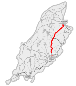
The A18 Snaefell Mountain Road or Mountain Road is a primary main A-road of 13.35 miles (21.48 km) in length which connects the towns of Douglas and Ramsey in the Isle of Man.
The Isle of Man TT Mountain Course or TT Course or Jalmaf Mountain Course is a street and public rural road circuit located in the Isle of Man, used for motorcycle racing. The motorcycle TT Course is used principally for the Isle of Man TT Races and also the separate event of the Isle of Man Festival of Motorcycling for the Manx Grand Prix and Classic TT Races held in September of each year. The start-line for the Isle of Man TT Mountain Course is located on Glencrutchery Road in the town of Douglas, Isle of Man.
26th Milestone, Isle of Man is situated on the primary A18 Snaefell Mountain Road in the parish of Lezayre in the Isle of Man. At the 26th Milestone racing marker used for the Isle of Man TT Races and Manx Grand Prix, the bend was named in honour of 26-times TT winner Joey Dunlop who died after a racing motorcycle crash in Estonia in July 2000. The area is the location of the only accident in which spectators at the Isle of Man TT races or Manx Grand Prix have been killed in a motorcycle racing accident.
Keppel Gate, Isle of Man is part of a former UK HM Commissioners of Woods and Forest estate, including a series of former highway mountain gates. It is now Common land in public ownership and is one of three purpose built former Crown Road sections of the A18 Snaefell Mountain Road used for the Isle of Man TT races. The area of Keppel Gate including a nearby private residence of Kate's Cottage at the adjacent 34th TT Milestone road-side marker is located between the 4th Milestone and 5th Milestone road-side markers on the primary A18 Snaefell Mountain Road in the parish district of Kirk Onchan in the Isle of Man.
Creg-ny-Baa is located between the 3rd Milestone and 4th Milestone of the primary A18 Snaefell Mountain Road and the road junction with the secondary B12 'Creg-ny-Baa Back-Road', in the parish of Kirk Onchan in the Isle of Man.
The Verandah, Isle of Man is a series of four bends which motorcyclists negotiate at high speed during road racing on the Snaefell Mountain Course on the Isle of Man.
Bungalow Station is the only intermediate station on the Isle of Man's Snaefell Mountain Railway and is located where the main mountain road intersects the line.
Highlander is situated between the 5th and 6th Milestone road-side markers on the Snaefell Mountain Course used for the Isle of Man TT races on the primary A1 Douglas to Peel road in the parish of Marown in the Isle of Man.
Ramsey Hairpin is a point on the Snaefell Mountain Course used for the Isle of Man TT races on the Snaefell Mountain Road, designated as A18, in the parish of Maughold in the Isle of Man.
The Four Inch Course was a road-racing circuit first used for the 1908 Tourist Trophy Race for cars, held on public roads closed for racing by an Act of Tynwald. The name of the course derives from the regulations for the 1908 Tourist Trophy adopted by the Royal Automobile Club, which limited the competitors' engines to a cylinder-diameter of four inches. The Four-Inch Course was adopted by the Auto-Cycle Club for the 1911 Isle of Man TT Races. The Four-Inch Course was subsequently known as the Snaefell Mountain Course or Mountain Course when used for motor-cycle racing.
Ballig is a small hamlet of a few houses situated between the 8th and 9th Milestone road-side markers on the Snaefell Mountain Course between Ballacraine and Glen Helen. It is the site of a former notorious hump-back bridge used for the Isle of Man TT Races on the primary A3 Castletown to Ramsey and the road junction with the A20 Poortown Road in the parish of German in the Isle of Man.
Brandywell, Isle of Man or is an area of Mountain Lands of heath moorland and coniferous woodland plantations situated in the Northern Upland Massif in the parish of Kirk Michael in the Isle of Man. The area was previously used by local shepherds due to a local stream and a nearby former venerated water well which was known for its distinctive quality and "brandy" colour of the water.
Kate's Cottage, Isle of Man is a cottage and one of the named corners of the Snaefell Mountain Course used in Grand Prix-style motorcycle racing along public roadways of the Isle of Man. It has been asserted in the Isle of Man's program of Registered Buildings that the cottage was built by 1869.
Cronk-ny-Mona is situated between the 36 and 37 mile markers used for the Snaefell Mountain Course, being on the primary A18 Mountain Road at the road junction with the A21 Johnny Watterson('s) Lane and the tertiary C10 Scholag Road in the Isle of Man parish of Onchan.
The Mountain Mile is a 1.3 mile section of a purpose-built graded road situated between the 27th and 29th Milestone roadside markers on the Snaefell Mountain Course used for the Isle of Man TT and Manx Grand Prix races on the A18 Mountain Road in the parish of Lezayre in the Isle of Man.
Whitegates, a left-curve, is situated adjacent to the 24th mile road-side marker measured from the start/finish line on the Snaefell Mountain Course used for the Isle of Man TT and Manx Grand Prix motorcycle races. The area also has the historic 15th milestone on the primary A18 Mountain Road, showing the distance from Douglas, Isle of Man to the town of Ramsey.
Hailwood's Height, preceded by Hailwood's Rise, is situated between the 31st and 32nd Milestone road-side markers on the Snaefell Mountain Course used for the Isle of Man TT Races on the A18 Snaefell Mountain Road in the parishes of Lezayre and Lonan in the Isle of Man.
This page is based on this Wikipedia article Text is available under the CC BY-SA 4.0 license; additional terms may apply. Images, videos and audio are available under their respective licenses.