The name was derived from two former white gates at the entrance of the Claughbane Road and the nearby Claughbane Farm.[1] The bend at Whitegates was part of the Highland Course and the Four Inch Course used for the Gordon Bennett Trial and RAC Tourist Trophy car races held in the Isle of Man between 1904 and 1922. Whitegates is part of the Snaefell Mountain Course used since 1911 for the Isle of Man TT and 1923 for the Manx Grand Prix races.
The road junction at Whitegates is the staging area for the Lhergy Frissell hillclimb, part of the Manx Classic Hill Climb events.[citation needed]
Sources
↑ TT 100 The Official Authorised History of Isle of Man Tourist Trophy Racing page 23 by Mick Duckworth Editor Miles Coswell (2007)(1st Edition) Lily Publications Ltd ISBN1-899602-67-4
26th Milestone, Isle of Man is situated on the primary A18 Snaefell Mountain Road in the parish of Lezayre in the Isle of Man. At the 26th Milestone racing marker used for the Isle of Man TT Races and Manx Grand Prix, the bend was named in honour of 26-times TT winner Joey Dunlop who died after a racing motorcycle crash in Estonia in July 2000. The area is the location of the only accident in which spectators at the Isle of Man TT races or Manx Grand Prix have been killed in a motorcycle racing accident.
Highlander is situated between the 5th and 6th Milestone road-side markers on the Snaefell Mountain Course used for the Isle of Man TT races on the primary A1 Douglas to Peel road in the parish of Marown in the Isle of Man.
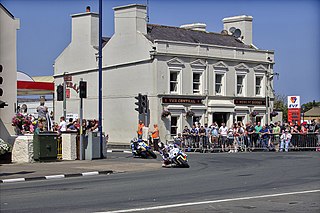
Parliament Square, Ramsey is situated between the 23rd and 24th Milestone road-side markers on the Snaefell Mountain Course used for the Isle of Man TT Races on the junction of the primary A3 Castletown to Ramsey road, the A9 Ramsey to Andreas road and A2 Douglas to Ramsey road situated in the town of Ramsey in the parish of Lezayre in the Isle of Man.
School House Corner is a left curve on the primary A3 Lezayre Road in Ramsey, Isle of Man.
Ramsey Hairpin is a point on the Snaefell Mountain Course used for the Isle of Man TT races on the Snaefell Mountain Road, designated as A18, in the parish of Maughold in the Isle of Man.
The Four Inch Course was a road-racing circuit first used for the 1908 Tourist Trophy Race for cars, held on public roads closed for racing by an Act of Tynwald. The name of the course derives from the regulations for the 1908 Tourist Trophy adopted by the Royal Automobile Club, which limited the competitors' engines to a cylinder-diameter of four inches. The Four-Inch Course was adopted by the Auto-Cycle Club for the 1911 Isle of Man TT Races. The Four-Inch Course was subsequently known as the Snaefell Mountain Course or Mountain Course when used for motor-cycle racing.
Ballig is a small hamlet of a few houses situated between the 8th and 9th Milestone road-side markers on the Snaefell Mountain Course between Ballacraine and Glen Helen. It is the site of a former notorious hump-back bridge used for the Isle of Man TT Races on the primary A3 Castletown to Ramsey and the road junction with the A20 Poortown Road in the parish of German in the Isle of Man.
Kate's Cottage, Isle of Man is a cottage and one of the named corners of the Snaefell Mountain Course used in Grand Prix-style motorcycle racing along public roadways of the Isle of Man. It has been asserted in the Isle of Man's program of Registered Buildings that the cottage was built by 1869.
The Bungalow, Isle of Man, one of a handful of better-known vantage points spread around the Snaefell Mountain Course, is situated adjacent to the 31st Milestone roadside marker on the road junction of the primary A18 Mountain Road, the A14 Sulby Glen Road and the road-tramway crossing for the Snaefell Mountain Railway in the parish of Lezayre in the Isle of Man.
Hillberry Corner is situated at the 36th Milestone road-side marker on the Snaefell Mountain Course, being on the primary A18 Mountain Road with the side-road junction of the C22 Little Mill Road, in the parish of Onchan in the Isle of Man.
Appledene is situated between the 6th and 7th roadside mile-markers, measured from the startline of the Snaefell Mountain Course used for the Isle of Man TT races, on the primary A1 Douglas to Peel road in the Isle of Man parish of German.
Ballaspur is situated between the 7th and 8th Milestone road-side markers on the Snaefell Mountain Course used for the Isle of Man TT races on the A3 Castletown to Ramsey road in the parish of German in the Isle of Man.
Creg Willey's Hill, Craig Wyllys, or Creg Willey's is situated close to the 10th milestone road-side marker after Sarah's Cottage on the Snaefell Mountain Course used for the Isle of Man TT races on the primary A3 Castletown to Ramsey road in the parish of German in the Isle of Man.
Cronk-ny-Mona is situated between the 36 and 37 mile markers used for the Snaefell Mountain Course, being on the primary A18 Mountain Road at the road junction with the A21 Johnny Watterson('s) Lane and the tertiary C10 Scholag Road in the Isle of Man parish of Onchan.
The Mountain Mile is a 1.3 mile section of a purpose-built graded road situated between the 27th and 29th Milestone roadside markers on the Snaefell Mountain Course used for the Isle of Man TT and Manx Grand Prix races on the A18 Mountain Road in the parish of Lezayre in the Isle of Man.
Ballacobb is situated between the 16th and 17th Milestone road-side markers on the Snaefell Mountain Course, on the primary A3 Castletown to Ramsey road at the side-junction with the tertiary U16 Slieu Curn Road, in the parish of Ballaugh in the Isle of Man.
Alpine Cottage including the adjacent Alpine House is situated between the 16th and 17th Milestone road-side markers on the Snaefell Mountain Course on the primary A3 Castletown to Ramsey road in the parish of Ballaugh in the Isle of Man.
Quarterbridge Road is a section of roadway notable for its inclusion in the Isle of Man TT races.
Douglas Road Corner or Kirk Michael Corner is situated adjacent the 14th Milestone road-side marker on the Snaefell Mountain Course on the primary A3 Castletown to Ramsey Road and the road junction with the A4 Peel to Kirk Michael Coast Road in the parish of Michael in the Isle of Man.
Hailwood's Height, preceded by Hailwood's Rise, is situated between the 31st and 32nd Milestone road-side markers on the Snaefell Mountain Course used for the Isle of Man TT Races on the A18 Snaefell Mountain Road in the parishes of Lezayre and Lonan in the Isle of Man.
This page is based on this Wikipedia article Text is available under the CC BY-SA 4.0 license; additional terms may apply. Images, videos and audio are available under their respective licenses.