Arcevia

Last updated • 2 min readFrom Wikipedia, The Free Encyclopedia
Arcevia
Città di Arcevia
Vista di Arcevia - 1.JPG
Arcevia-Stemma.png
Location of Arcevia
Arcevia
Italy provincial location map 2016.svg
Red pog.svg
Arcevia
Location of Arcevia in Italy
Italy Marche location map.svg
Red pog.svg
Arcevia
Arcevia (Marche)
Coordinates: 43°30′N12°56′E / 43.500°N 12.933°E / 43.500; 12.933
Country Italy
Region Marche
Province Ancona (AN)
Frazioni Avacelli, Castiglioni, Caudino, Colle Aprico, Conce di Arcevia, Costa, Loretello, Magnadorsa, Montale, Monte Sant'Angelo, Nidastore, Palazzo, Piticchio, Prosano, Ripalta, San Ginesio di Arcevia, San Giovanni Battista, San Pietro in Musio, Sant'Apollinare, Santo Stefano
Government
  MayorAndrea Bomprezzi
Area
[1]
  Total126.25 km2 (48.75 sq mi)
Elevation
535 m (1,755 ft)
Population
 (30 April 2017 [2] ) [3]
  Total4,518
  Density36/km2 (93/sq mi)
Demonym Arceviesi
Time zone UTC+1 (CET)
  Summer (DST) UTC+2 (CEST)
Postal code
60011
Dialing code 0731
Patron saintSt. Medardus
Saint dayJune 8
Website Official website

Arcevia is a comune in the province of Ancona of the region of Marche, central-eastern Italy. It is one of I Borghi più belli d'Italia ("The most beautiful villages of Italy"). [4]

Contents

History

According to tradition, Arcevia originates from a Gallic settlement anterior to the Roman conquest of Italy; following that, it became overshadowed by more important nearby cities, such as Suasa.

Under the name of Rocca Contrada, the town was fortified by Pippin the Younger, King of the Franks, and was then donated by Charlemagne to the Papal States. In the following centuries, Arcevia played a key role in the local balance of power, located as it was at the border of the Marca di Ancona, Umbria, and the Duchy of Urbino. In 1201, Rocca Contrada proclaimed itself a commune independent from Rome, and was indeed recognised as civitas (Latin for "city") by pope Clement IV in 1266, and remained a guelph city ever since.

Known on a local scale for its military might, Rocca Contrada became entwined in the struggles between the numerous conflicts between local powers, until in the 15th century it found itself under siege by Ladislaus, King of Naples, and decided to call upon the help of famous condottiero Braccio da Montone. The latter vanquished the assailants and reconquered the castles around Arcevia they had occupied; for this he was proclaimed Signore of the city. Later on, the troops of Francesco Sforza overtook Rocca Contrada, which, after several vicissitudes, ended up under the rule of the guelph Malatesta family.

After the pacification of the Papal States in the 16th century, Rocca Contrada flourished in the Italian Renaissance: the city witnessed the institution of professorships in classical subjects, the founding of literary academies, and the birth of such significant artists as painter Ercole Ramazzani and architect Andrea Vici in the 18th century.

In 1817, pope Pius VII renamed Rocca Contrada with the current official name of Arcevia. The town passed to the Kingdom of Italy after the unification of the country under the Savoy monarchy. Townspeople fought in the two world wars, and paid for their resistance to Nazi occupation with the slaughter of seventy people on Monte Sant'Angelo (Marche) in May 1944.

Geography and subdivisions

Arcevia is about 535 metres (1,755 ft) above sea level, on a hill overlooking the valley of the Misa river and the Nevola river, about 50 kilometres (31 mi) south-west from its provincial and regional capital, Ancona.

Arcevia borders the following municipalities: Barbara, Castelleone di Suasa, Genga, Mergo, Montecarotto, Pergola, Rosora, San Lorenzo in Campo, Sassoferrato, Serra de' Conti, and Serra San Quirico.

Notable people

Twin towns

Related Research Articles

<span class="mw-page-title-main">Cesena</span> Comune in Emilia-Romagna, Italy

Cesena is a city and comune (municipality) in the Emilia-Romagna region of Italy, served by Autostrada A14, and located near the Apennine Mountains, about 15 kilometres from the Adriatic Sea. The total population is 97,137.

<span class="mw-page-title-main">Fano</span> Comune in Marche, Italy

Fano is a town and comune of the province of Pesaro and Urbino in the Marche region of Italy. It is a beach resort 12 kilometres southeast of Pesaro, located where the Via Flaminia reaches the Adriatic Sea. It is the third city in the region by population after Ancona and Pesaro.

<span class="mw-page-title-main">Sassoferrato</span> Comune in Marche, Italy

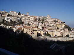
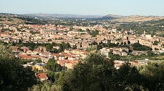
Sassoferrato is a town and comune of the province of Ancona in the Marche region of central-eastern Italy. It is one of I Borghi più belli d'Italia.

<span class="mw-page-title-main">Senigallia</span> Comune in Marche, Italy

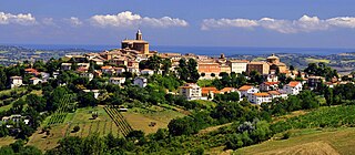
Senigallia is a comune and port town on Italy's Adriatic coast. It is situated in the province of Ancona in the Marche region and lies approximately 30 kilometers north-west of the provincial capital city Ancona. Senigallia's small port is located at the mouth of the river Misa. It is one of the endpoints of the Massa-Senigallia Line, one of the most important dividing lines (isoglosses) in the classification of the Romance languages.

<span class="mw-page-title-main">Fermo</span> Comune in Marche, Italy

Fermo is a town and comune of the Marche, Italy, in the Province of Fermo.

<span class="mw-page-title-main">Camerino</span> Comune in Marche, Italy

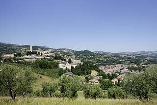
Camerino is a town in the province of Macerata, Marche, central-eastern Italy. It is located in the Apennines bordering Umbria, between the valleys of the rivers Potenza and Chienti, about 64 kilometres (40 mi) from Ancona.

<span class="mw-page-title-main">Osimo</span> Comune in Marche, Italy

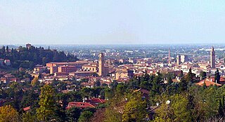
Osimo is a town and comune of the Marche region of Italy, in the province of Ancona. The municipality covers a hilly area located approximately 15 kilometres (9.3 mi) south of the port city of Ancona and the Adriatic Sea.

<span class="mw-page-title-main">Tolentino</span> Comune in Marche, Italy

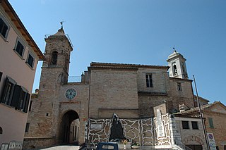
Tolentino is a town and comune of about 19,000 inhabitants, in the province of Macerata in the Marche region of central Italy.

<span class="mw-page-title-main">Urbania</span> Comune in Marche, Italy

Urbania is a comune (municipality) in the Province of Pesaro e Urbino in the Italian region of Marche, located about 80 kilometres (50 mi) west of Ancona and about 40 kilometres (25 mi) southwest of Pesaro, next to the river Metauro.

<span class="mw-page-title-main">Barbara, Marche</span> Comune in Marche, Italy

Barbara is a comune (municipality) in the Province of Ancona in the Italian region Marche, located about 40 kilometres (25 mi) west of Ancona. As of 31 December 2004, it had a population of 1,484 and an area of 10.8 square kilometres (4.2 sq mi).

Mergo is a comune (municipality) in the Province of Ancona in the Italian region Marche, located about 40 kilometres (25 mi) southwest of Ancona. As of 31 December 2004, it had a population of 1,063 and an area of 7.3 square kilometres (2.8 sq mi).

<span class="mw-page-title-main">Montecarotto</span> Comune in Marche, Italy

Montecarotto is a comune (municipality) in the Province of Ancona in the Italian region Marche, located about 40 kilometres (25 mi) west of Ancona, mostly known internationally for the annual Blackmoon festival, a renowned goa and psytrance happening. As of 31 December 2004, it had a population of 2,163 and an area of 24.1 square kilometres (9.3 sq mi).

<span class="mw-page-title-main">Rosora</span> Comune in Marche, Italy

Rosora is a comune (municipality) in the Province of Ancona in the Italian region Marche, located about 40 kilometres (25 mi) southwest of Ancona.

Serra de' Conti is a comune (municipality) in the Province of Ancona in the Italian region Marche, located about 40 kilometres (25 mi) west of Ancona.

<span class="mw-page-title-main">Mogliano</span> Comune in Marche, Italy

Mogliano is a comune (municipality) in the Province of Macerata in the Italian region Marche, located about 50 kilometres (31 mi) south of Ancona and about 13 kilometres (8 mi) south of Macerata.

<span class="mw-page-title-main">San Severino Marche</span> Comune in Marche, Italy

San Severino Marche is a comune (municipality) in the Province of Macerata in the Italian region Marche, located about 50 kilometres (31 mi) southwest of Ancona and about 25 kilometres (16 mi) southwest of Macerata.

<span class="mw-page-title-main">Montalto delle Marche</span> Comune in Marche, Italy

Montalto delle Marche is a comune (municipality) and former Latin catholic bishopric in the Province of Ascoli Piceno in the Italian region Le Marche, located in the hilly area that goes from the Adriatic cost to the Sibillini Mountains, at a distance of about 70 kilometres (43 mi) south of Ancona and about 15 kilometres (9 mi) north of Ascoli Piceno, with a population of 1 991 inhabitants. The municipal territory covers a 34 km² area.

<span class="mw-page-title-main">Offida</span> Comune in Marche, Italy

Offida is a comune (municipality) in the province of Ascoli Piceno, in the Italian region of Marche, located about 80 km south of Ancona and about 12 km northeast of Ascoli Piceno, on a rocky spur between the valleys of the Tesino and Tronto (south) rivers. It is one of I Borghi più belli d'Italia.

<span class="mw-page-title-main">Stroncone</span> Comune in Umbria, Italy

Stroncone is a comune (municipality) in the Province of Terni in the Italian region Umbria, located about 70 km southeast of Perugia and about 8 km south of Terni. It is one of I Borghi più belli d'Italia.

<span class="mw-page-title-main">Sant'Andrea di Suasa</span> Town in Marche, Italy

Sant'Andrea di Suasa is a hamlet of the municipality of Mondavio in the province of Pesaro-Urbino, Italy. The castle-village sits 265 metres above sea level, 23 km from the Adriatic coast and develops along the crest of a large hill to the left of the Cesano river. It is characterized by the mighty wall circuit still intact with a single arch entrance.

References

  1. "Superficie di Comuni Province e Regioni italiane al 9 ottobre 2011". Italian National Institute of Statistics. Retrieved 16 March 2019.
  2. Data from ISTAT
  3. "Popolazione Residente al 1° Gennaio 2018". Italian National Institute of Statistics. Retrieved 16 March 2019.
  4. "Marche" (in Italian). Retrieved 1 August 2023.