
Buckie is a burgh town on the Moray Firth coast of Scotland. Historically in Banffshire, Buckie was the largest town in the county until the administrative area was abolished in 1975. The town is the third largest in the Moray council area after Elgin and Forres and within the definitions of statistics published by the General Register Office for Scotland was ranked at number 75 in the list of population estimates for settlements in Scotland mid-year 2006. Buckie is virtually equidistant to Banff to the east and Elgin to the west, with both approximately 17 miles distant whilst Keith lies 12 mi (19 km) to the south by road.
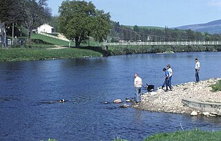
The River Spey is a river in the northeast of Scotland. At 98 mi (158 km) it is the eigth longest river in the United Kingdom and the second longest and fastest-flowing river in Scotland. (The Tay is the longest with the Clyde third in Scotland. It is an important location for the traditions of salmon fishing and whisky production in Scotland.

Cornsay is a hamlet and civil parish in County Durham, England. The population of the Civil Parish taken at the 2011 census was 1,128. It is 6 miles (9.7 km) southeast of Consett and 7 miles (11 km) southwest of Durham. It consists of nineteen dwellings, including four farms & is the home of Greenacres nudist club. All formerly belonged to Ushaw College for the training of Catholic priests, hence the organised nomenclature. East and West Farms are now in private hands as homes but the other two are still active, South Farm run by the Suddes family and North Farm by the Tweddle family.

West Barns is a small village in East Lothian, Scotland. It lies 2 miles west of Dunbar and approximately 28 miles east of Edinburgh. It is close to John Muir Country Park and Belhaven Bay. For many years, it was home to the West Barns Inn and is still home to the West Barns Bowling Club. It was home to a major John Deere farm machinery dealership, that moved to Haddington in 2017, the site being taken over by the Thistly Cross Cider Company. There is also a local amateur football team, West Barns Star. Children of primary-school age attend West Barns Primary, after which they will go to Dunbar Grammar School.
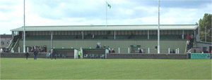
Victoria Park is a football ground in Buckie in north-east Scotland, which is the home ground of Highland Football League side Buckie Thistle. It is located at the junction of Midmar Street and South Pringle Street, 0.5 miles (0.8 km) from the town centre. The ground has a capacity of 5,000 with 400 seated, and is currently the largest in the league.

Portlethen Village is a settlement located to the east of Portlethen along the North Sea coast in Aberdeenshire, Scotland. The village is also known as Old Portlethen. The skerry of Craigmaroinn is situated just off the coastline near Portlethen Village.
Eden Water is a tributary of the River Tweed in the Scottish Borders of Scotland. "Water" is the Lowland Scots term for a small river.

Cowpe is a hamlet in Rossendale, Lancashire, England. It lies in the South Pennines, north of Scout Moor Wind Farm, by the Pennine Bridleway. Rawtenstall is to the west, Bacup to the east and Waterfoot to the north. Directly south over Brandwood and Scout Moors, is Rochdale. 'Cowpe' is thought to derive from 'Cow Pastures'.
Aultmore is a village in Moray, Scotland, near Keith.

Cairnie, also written Cairney, is a village in Aberdeenshire, Scotland.

Portgordon, or sometimes Port Gordon, is a village in Moray, Scotland, 2 km south-west of Buckie. It was established in 1797 by Alexander Gordon, 4th Duke of Gordon as a fishing village. It had a population of 844 at the time of the 2011 census. The Portgordon Community Harbour Group was trying to regenerate the harbour and open a marina.

Carron is a small village on the north bank of the River Spey in Moray, Scotland.

Boat How or Eskdale Moor is a hill in the English Lake District, near Boot, in the Borough of Copeland, Cumbria. It lies south of Burnmoor Tarn, between the River Mite to the west and the Whillan Beck tributary of Eskdale to the east.

St Mary's, Fochabers is a Roman Catholic church in the village of Fochabers, Moray, in Scotland and is a part of the RC Diocese of Aberdeen. The building is significant for the high quality of its altar and stained glass windows. It is an active parish church served from Buckie with regular weekly Sunday Mass at 10.00 am.

St Peter's Roman Catholic Church is a large mid-nineteenth century church in Buckie, Moray, Scotland. Known locally as the Buckie Cathedral, it was built between 1851 and 1857, soon after the emancipation of Catholics in Scotland, to provide a place of worship for the local Catholic congregation. It was designed by James Kyle, Catholic bishop of Aberdeen, and built on land donated to the diocese by Sir William Gordon, Baronet of Letterfourie. It was extended and redecorated in the early twentieth century by Charles Ménart, and was designated a Category A listed building in 1972. It remains an active place of worship, under the governance of the Roman Catholic Diocese of Aberdeen.

Gibbet Moor is a small gritstone upland area in the Derbyshire Peak District of central and northern England, near the village of Baslow. Its highest point is 295 metres (968 ft) above sea level. The Chatsworth Estate lies to the west and Umberley Brook runs along its east edge. East Moor is the broader moorland area covering Gibbet Moor, Brampton East Moor and Beeley Moor. Gibbet Moor is a prehistoric landscape with several protected Scheduled Ancient Monuments.

Totley Moor is an open moorland hill to the west of the Sheffield suburb of Totley, in the Derbyshire Peak District. The summit is 395 metres (1,296 ft) above sea level.
John Malcolm Bulloch (1867–1938) was a Scottish journalist and magazine editor, known also as a genealogist, and a literary and theatre critic.


