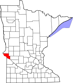
Artichoke, Minnesota

Last updated

Artichoke
USA Minnesota location map.svg
Red pog.svg
Artichoke
Usa edcp location map.svg
Red pog.svg
Artichoke
Coordinates: 45°23′57″N96°09′27″W / 45.39917°N 96.15750°W / 45.39917; -96.15750
Country United States
State Minnesota
County Big Stone
Elevation
1,093 ft (333 m)
Time zone UTC-6 (Central (CST))
  Summer (DST) UTC-5 (CDT)
Area code 320
GNIS feature ID654575 [1]

Artichoke is an unincorporated community in Artichoke Township, Big Stone County, Minnesota, United States. [1]

Artichoke is located at the intersection between 600th ave and Big stone county Rd 8.

Notes

  1. 1 2 "Artichoke, Minnesota". Geographic Names Information System . United States Geological Survey, United States Department of the Interior.


Related Research Articles

<span class="mw-page-title-main">Grant County, South Dakota</span> County in South Dakota, United States

Grant County is a county in the U.S. state of South Dakota. As of the 2020 census, the population was 7,556. The county seat is Milbank. The county was founded in 1873 and organized in 1878. It is named for Ulysses S. Grant, 18th President of the United States.

<span class="mw-page-title-main">Big Stone County, Minnesota</span> County in Minnesota, United States

Big Stone County is a county in the U.S. state of Minnesota. As of the 2020 census, the population was 5,166. Its county seat is Ortonville.

Akron Township is a township in Big Stone County, Minnesota, United States. The population was 196 as of the 2000 census.

<span class="mw-page-title-main">Artichoke Township, Big Stone County, Minnesota</span> Township in Minnesota, United States

Artichoke Township is a township in Big Stone County, Minnesota, United States. The population was 84 as of the 2000 census. Artichoke is also the name of an unincorporated hamlet within Artichoke Township.

Malta Township is a township in Big Stone County, Minnesota, United States. The population was 90 at the 2000 census.

Odessa Township is a township in Big Stone County, Minnesota, United States. The population was 147 as of the 2000 census. Odessa Township was named after Odesa, Ukraine.

Otrey Township is a township in Big Stone County, Minnesota, United States. The population was 104 as of the 2000 census.

Culver Township is a township in Saint Louis County, Minnesota, United States. The population was 294 at the 2010 census.

<span class="mw-page-title-main">Ortonville, Minnesota</span> City in Minnesota, United States

Ortonville is a city in Big Stone County in the U.S. state of Minnesota at the southern tip of Big Stone Lake, along the border with South Dakota. The population was 2,021 at the 2020 census. It is the county seat of Big Stone County. Big Stone Lake State Park is nearby.

The globe artichoke is a species of thistle cultivated as a food. Artichoke may also refer to:

Alborn is an unincorporated community in Alborn Township, Saint Louis County, Minnesota, United States.

<span class="mw-page-title-main">Wapsipinicon River</span> River in Iowa and Minnesota in the United States of America

The Wapsipinicon River is a tributary of the Mississippi River, approximately 300 miles (480 km) long, starting near the southeastern border of Minnesota and running through northeastern Iowa in the United States. It drains a rural farming region of rolling hills and bluffs north of Waterloo and Cedar Rapids.

The Artichoke River is a 13.5-mile-long (21.7 km) tributary of the Saint Louis River in northeastern Minnesota in the United States.

<span class="mw-page-title-main">Traverse Gap</span> River channel in Minnesota, US

The Traverse Gap is an ancient river channel occupied by Lake Traverse, Big Stone Lake and the valley connecting them at Browns Valley, Minnesota. It is located on the border of the U.S. states of Minnesota and South Dakota. Traverse Gap has an unusual distinction for a valley: it is crossed by a continental divide, and in some floods, water has flowed across that divide from one drainage basin to the other. Before the Anglo-American Convention of 1818 it marked the border between British territory in the north and U.S. – or earlier, French – territory in the south.

Culver is an unincorporated community in Saint Louis County, Minnesota, United States.

Big Stone Wetland Management District is a protected area encompassing scattered wetlands in Lincoln and Lyon Counties, Minnesota, United States. It is operated by the U.S. Fish and Wildlife Service out of headquarters within Big Stone National Wildlife Refuge. District staff also serve private land resource interests by providing technical assistance for United States Department of Agriculture programs and restoring wetlands on private lands.

<span class="mw-page-title-main">National Register of Historic Places listings in Big Stone County, Minnesota</span>

This is a list of the National Register of Historic Places listings in Big Stone County, Minnesota. It is intended to be a complete list of the properties and districts on the National Register of Historic Places in Big Stone County, Minnesota, United States. Latitude and longitude coordinates are provided for many National Register properties and districts; these locations may be seen together in an online map.

<span class="mw-page-title-main">2012 United States presidential election in Minnesota</span>

The 2012 United States presidential election in Minnesota took place on November 6, 2012, as part of the 2012 United States presidential election in which all 50 states plus the District of Columbia participated. State voters chose ten electors to represent them in the Electoral College via a popular vote pitting incumbent Democratic President Barack Obama and his running mate, Vice President Joe Biden, against Republican challenger and former Massachusetts Governor Mitt Romney and his running mate, Congressman Paul Ryan.

Artichoke Lake is a lake in Big Stone and Swift counties, Minnesota, in the United States.

Big Stone Colony is an unincorporated community in Graceville Township, Big Stone County, Minnesota, United States, where, as of 2010 the population was 5,269.