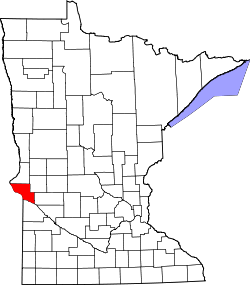
Big Stone Colony | |
---|---|
Coordinates: 45°31′45″N96°28′27″W / 45.52917°N 96.47417°W | |
Country | United States |
State | Minnesota |
County | Big Stone |
Elevation | 1,125 ft (343 m) |
Time zone | UTC-6 (Central (CST)) |
• Summer (DST) | UTC-5 (CDT) |
Area code | 320 |
GNIS feature ID | 640133 [1] |
Big Stone Colony is an unincorporated community in Graceville Township, Big Stone County, Minnesota, United States, [1] where, as of 2010 the population was 5,269.[ citation needed ]
Roberts County is a county in the U.S. state of South Dakota. As of the 2020 United States Census, the population was 10,280. Its county seat is Sisseton. The county was named either for S. G. Roberts of Fargo, North Dakota, or for Solomon Robar, an early local French fur trader. It was created on March 8, 1883, and fully organized by August 6 of that year. Its boundary was altered once, in 1885.
Big Stone County is a county in the U.S. state of Minnesota. As of the 2020 census, the population was 5,166. Its county seat is Ortonville.
Graceville is a city in Big Stone County, Minnesota, United States. The population was 529 at the 2020 census.
Graceville Township is a township in Big Stone County, Minnesota, United States. The population was 205 as of the 2000 census. Graceville Township took its name from the city of Graceville, which was named for Thomas Langdon Grace, second Roman Catholic Bishop of Saint Paul, Minnesota.
Big Stone Township is a township in Big Stone County, Minnesota, United States. The population was 253 at the 2000 census.
Worthington is a city in and the county seat of Nobles County, Minnesota, United States. The population was 13,947 at the time of the 2020 census.
Ortonville is a city in Big Stone County in the U.S. state of Minnesota at the southern tip of Big Stone Lake, along the border with South Dakota. The population was 2,021 at the 2020 census. It is the county seat of Big Stone County. Big Stone Lake State Park is nearby.
The territory of the United States and its overseas possessions has evolved over time, from the colonial era to the present day. It includes formally organized territories, proposed and failed states, unrecognized breakaway states, international and interstate purchases, cessions, and land grants, and historical military departments and administrative districts. The last section lists informal regions from American vernacular geography known by popular nicknames and linked by geographical, cultural, or economic similarities, some of which are still in use today.
Big Stone Lake is a long, narrow freshwater lake and reservoir on the border between western Minnesota and northeastern South Dakota in the United States.
Big Stone Lake State Park is a state park of Minnesota, United States, on the shore of Big Stone Lake, the headwaters of the Minnesota River. It is home to wildlife including deer, raccoons, squirrels, meadowlarks, sedge wrens, pheasants, bobolinks, wild turkeys, thrashers, and mourning doves. The two sections of the park, the Bonanza Area in the north and the Meadowbrook Area in the south, are 12 miles (19 km) apart. South Dakota's Hartford Beach State Park is on the opposite shore of the lake. Big Stone Lake State Park is used for picnics, camping, hiking, and other outdoor recreation.
The Red River Trails were a network of ox cart routes connecting the Red River Colony and Fort Garry in British North America with the head of navigation on the Mississippi River in the United States. These trade routes ran from the location of present-day Winnipeg in the Canadian province of Manitoba across the Canada–United States border, and thence by a variety of routes through what is now the eastern part of North Dakota and western and central Minnesota to Mendota and Saint Paul, Minnesota on the Mississippi.
The Traverse Gap is an ancient river channel occupied by Lake Traverse, Big Stone Lake and the valley connecting them at Browns Valley, Minnesota. It is located on the border of the U.S. states of Minnesota and South Dakota. Traverse Gap has an unusual distinction for a valley: it is crossed by a continental divide, and in some floods water has flowed across that divide from one drainage basin to the other. Before the Anglo-American Convention of 1818 it marked the border between British territory in the north and U.S. – or earlier, French – territory in the south.
Straddling the headwaters of the Minnesota River in west-central Minnesota, Big Stone National Wildlife Refuge is within the heart of the tallgrass prairie's historic range. Today, less than one-percent of tallgrass prairie remains.
Big Stone Wetland Management District is a protected area encompassing scattered wetlands in Lincoln and Lyon Counties, Minnesota, United States. It is operated by the U.S. Fish and Wildlife Service out of headquarters within Big Stone National Wildlife Refuge. District staff also serve private land resource interests by providing technical assistance for United States Department of Agriculture programs and restoring wetlands on private lands.
This is a list of the National Register of Historic Places listings in Big Stone County, Minnesota. It is intended to be a complete list of the properties and districts on the National Register of Historic Places in Big Stone County, Minnesota, United States. Latitude and longitude coordinates are provided for many National Register properties and districts; these locations may be seen together in an online map.
The 2012 United States presidential election in Minnesota took place on November 6, 2012, as part of the 2012 United States presidential election in which all 50 states plus the District of Columbia participated. State voters chose ten electors to represent them in the Electoral College via a popular vote pitting incumbent Democratic President Barack Obama and his running mate, Vice President Joe Biden, against Republican challenger and former Massachusetts Governor Mitt Romney and his running mate, Congressman Paul Ryan.
Danebod is a historic district at the south edge of the railway town of Tyler in southwestern Minnesota. Founded in 1885 by Danish Evangelical Lutherans led by Rev. Hans Jørgen Pedersen (1851–1905), the district comprises a group of buildings dating back to 1888 from Minnesota's oldest Danish immigrant settlement. Danebod remains until this day a predominantly Danish Lutheran, close-knit religious community. An annual celebration named Æbleskiver Days, held on the fourth weekend of July, celebrates Danish heritage and culture and includes a parade that goes down the town's main street with floats that are made by the various Danebod neighborhoods.
Lagoona Beach is an unincorporated community in Big Stone Township, Big Stone County, Minnesota, United States.