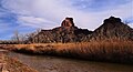
Mount Constance is a peak in the Olympic Mountains of Washington and the third highest in the range. It is the most visually prominent peak on Seattle's western skyline. Despite being almost as tall as the ice-clad Mount Olympus to the west, Mount Constance has little in the way of glaciers and permanent snow because the eastern, and particularly this northeastern, portion of the Olympics receives far less precipitation. However the narrow and steep Crystal Glacier still exists on the mountain's north face, shaded by the bulk of the main peak and with a small lake at its terminus. In addition, the treeline is higher here than mountains to the west, also hinting at the drier alpine conditions.
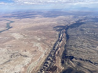
The San Rafael Swell is a large geologic feature located in south-central Utah, United States about 16 miles (26 km) west of Green River. The San Rafael Swell, measuring approximately 75 by 40 miles, consists of a giant dome-shaped anticline of sandstone, shale, and limestone that was pushed up during the Paleocene Laramide Orogeny 40–60 million years ago. Since that time, infrequent but powerful flash floods have eroded the sedimentary rocks into numerous valleys, canyons, gorges, mesas, buttes, and badlands.

Gladsheim Peak is a prominent 2,830-metre (9,280-foot) mountain summit located in the Valhalla Ranges of the Selkirk Mountains in British Columbia, Canada. Gladsheim is the highest point in the Valhalla Ranges. It is situated in the southern part of Valhalla Provincial Park, 2.7 km (1.7 mi) northeast of Gimli Peak, and 12 km (7.5 mi) west of Slocan and Slocan Lake. The name "Valhalla Mountains" first appeared in George Mercer Dawson's Geological Survey of Canada map published in 1890. Dawson applied names derived from Scandinavian mythology to several of the mountain ranges and peaks in Southern Kootenay. Gladsheim is the magnificent meeting hall containing thirteen council seats where, according to Norse mythology, Odin presided over all the realms. In keeping with the Valhalla theme, this peak's name was submitted in 1900 by R. W. Brock to the Geological Survey of Canada for consideration, and it was officially adopted March 31, 1924, by the Geographical Names Board of Canada.

Boulder Ridge is a 6,852-foot (2,088-metre) elevation mountain ridge located in the eastern Olympic Mountains in Jefferson County of Washington state. It is set within Buckhorn Wilderness on land managed by the Olympic National Forest. The nearest higher neighbor is Alphabet Ridge, 0.94 mi (1.51 km) to the south, and Buckhorn Mountain rises 1.3 mi (2.1 km) to the north. Precipitation runoff from Boulder Ridge drains east into headwaters of the Big Quilcene River, west into tributaries of Dungeness River, and south into Charlia Lakes, thence Tunnel Creek.

Window Blind Peak is a 7,030-foot-elevation (2,143-meter) summit located in the San Rafael Swell of Emery County, Utah, U.S. Towering 1,800 feet above its surrounding terrain, it is the highest point of the Mexican Mountain Wilderness Study Area. Ownership is administered by the Bureau of Land Management. It is situated 2.1 miles (3.4 km) southeast of Bottleneck Peak, 1.52 miles (2.45 km) south of Assembly Hall Peak, and the nearest higher neighbor is Cedar Mountain, 8.95 miles (14.40 km) to the north-northeast. Precipitation runoff from this feature drains north into the nearby San Rafael River. The first ascent of this peak was made September 23, 1973, by Jim Langdon, Dale Black, and Dave Palmer via the West Face.

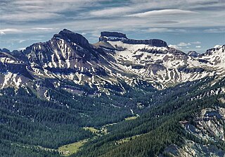
Temple Mountain is a remote 6,820-foot (2,080 m) mountain and abandoned town, located on the southeast flank of the San Rafael Swell in Emery County, Utah, United States.
Feather Peak is a 13,240-foot-elevation mountain summit located west of the Royce Lakes in the Sierra Nevada mountain range in northern California, United States. It is situated in Fresno County, in the John Muir Wilderness, on land managed by Sierra National Forest. It is set 3.2 miles (5.1 km) east-northeast of Seven Gables, and 0.66 miles (1.06 km) northwest of Royce Peak, which is the nearest higher neighbor. Feather Peak ranks as the 99th-highest summit in California. The first ascent of the summit was made in July 1933 by David Brower, who also named this peak.

Mount Carillon is a 13,559-foot-elevation (4,133-meter) mountain summit located on the crest of the Sierra Nevada mountain range in California. It is situated on the common border of Tulare County with Inyo County, as well as the shared boundary of Sequoia National Park and John Muir Wilderness. It is set above the south shore of Tulainyo Lake, 12.5 miles (20.1 km) west of the community of Lone Pine, 1.25 miles (2.01 km) northeast of Mount Whitney, and 0.7 miles (1.1 km) east-northeast of Mount Russell, the nearest higher neighbor. Topographic relief is significant as it rises approximately 5,180 feet above Whitney Portal in approximately two miles. Carillon has subpeaks, unofficially called "The Cleaver" (13,383 ft, 0.4 mile to the northeast, and "Impala", on the southeast ridge.
Coxcomb Peak is a 13,656-foot-elevation (4,162-meter) mountain summit located on the common boundary of Hinsdale County and Ouray County, in Colorado, United States. It is situated nine miles northeast of the community of Ouray, in the Uncompahgre Wilderness, on land managed by Uncompahgre National Forest. It is part of the San Juan Mountains which are a subset of the Rocky Mountains, and is situated west of the Continental Divide. Coxcomb ranks as the 171st-highest peak in Colorado, and topographic relief is significant as the south aspect rises 2,000 feet above Wetterhorn Basin in approximately one mile, and 4,400 feet above Cow Creek in three miles. Neighbors include Precipice Peak 2.7 miles to the north, Redcliff one-half mile north, Matterhorn Peak 2.3 miles to the east-southeast, and nearest higher neighbor Wetterhorn Peak 1.8 mile to the southeast. The mountain's descriptive name, which has been officially adopted by the United States Board on Geographic Names, was in use since at least 1906 when Henry Gannett published it in the Gazetteer of Colorado.

Clyde Peak is an 8,610-foot-elevation (2,620-meter) mountain summit located in Glacier National Park in the U.S. state of Montana. The mountain straddles the border shared by Flathead County and Glacier County. It is situated on the Continental Divide so precipitation runoff from the west side of the mountain drains into Thompson Creek which is part of the Middle Fork Flathead River watershed, and the east side drains into headwaters of Red Eagle Creek, which flows to Red Eagle Lake, thence Saint Mary Lake. It is set in the Lewis Range, and the nearest higher neighbor is Mount Logan 1.44 mile to the northwest. Topographic relief is significant as the southwest aspect rises approximately 4,000 feet in one mile.

Mount Delabarre is a remote 6,024-foot (1,836-metre) mountain summit deep within Olympic National Park in Jefferson County of Washington state. Part of the Olympic Mountains, Mount Delabarre is 12.4 miles southeast of Mount Olympus, set within the Daniel J. Evans Wilderness. The nearest higher neighbor is line parent Mount Christie, 2.5 miles to the west-northwest. Precipitation runoff from the mountain drains north into headwaters of Delabarre Creek, which is a tributary of the Elwha River, and south into Rustler Creek, which is a tributary of the North Fork Quinault River. Topographic relief is significant as the southwest aspect of the peak rises 3,400 feet (1,036 m) above Rustler Creek in approximately one mile.

Tyler Peak is a 6,364 feet (1,940 m) mountain summit located in Clallam County of Washington state, United States. It is situated in the northeastern Olympic Mountains, near the northern end of Gray Wolf Ridge, and is set within Buckhorn Wilderness, on land managed by the Olympic National Forest. The next highest neighbor is Mt. Baldy, two miles to the west.

Petunia Peak is a 6,953-foot (2,119-metre) mountain summit located in Jefferson County of Washington state.
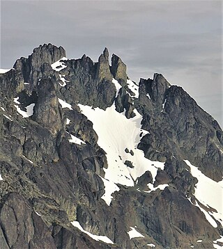
Sweat Spire is a 7,580-foot-elevation (2,310 meter) summit located in the Olympic Mountains, in Jefferson County of Washington state. It is situated within Olympic National Park, and is set within the Daniel J. Evans Wilderness. It is part of The Needles range, which is a subset of the Olympic range. The nearest higher peak is Mount Johnson, 0.06 mi (0.097 km) to the southwest, and Gasp Pinnacle (7,520 ft) is to the immediate north. The spire is in the rain shadow of the Olympic Range, resulting in less precipitation than Mount Olympus and the western Olympics receive. Precipitation runoff from the mountain drains east into Royal Creek, and west into Gray Wolf River, which are both within the drainage basin of the Dungeness River. Topographic relief is significant as the east aspect rises over 2,400 feet (730 m) above Royal Basin in approximately one mile. The first ascent of the 200-foot-tall spire was made in 1962 by Hilton Keith, Joel Merkel, Joe Munson, and Jim Parolini. This landform's name has not been officially adopted by the U.S. Board on Geographic Names, so the feature is not labeled on USGS maps.
Hawksbeak Peak is a mountain summit with an elevation of 11,134 feet (3,394 m) located on the crest of the Sierra Nevada mountain range, in northern California, United States. The granitic summit is situated on the common boundary shared by Yosemite National Park with Hoover Wilderness, as well as the common border of Mono County and Tuolumne County. This remote peak is set at the head of Thompson Canyon, approximately eight miles west of Twin Lakes and 17 miles southwest of Bridgeport, the nearest town. Topographic relief is significant as the west aspect rises over 1,300 feet in less than one-quarter mile. The class 5.10- West Face was first climbed in September 1989 by Alan Swanson and John Nye. This landform's toponym has been officially adopted by the U.S. Board on Geographic Names.

Ostler Peak is a 12,718-foot elevation (3,876 m) mountain summit located in Summit County, Utah, United States.

Mount Beulah is a 12,557-foot elevation (3,827 m) mountain summit located in Summit County, Utah, United States.

Spanish Fork Peak is a 10,192-foot elevation (3,107 m) mountain summit located in Utah County, Utah, United States.

Family Butte is a 7,405-foot-elevation (2,257-meter) summit in Emery County, Utah, United States.

Square Top is a 7,412-foot-elevation (2,259-meter) summit in Emery County, Utah, United States.