Window Blind Peak

Last updated
Window Blind Peak
Window Blind Peak, San Rafael Swell.jpg
Northeast aspect
Highest point
Elevation 7,030 ft (2,140 m) [1]
Prominence 1,410 ft (430 m) [1]
Parent peak Cedar Mountain (7,665 ft) [1]
Isolation 8.99 mi (14.47 km) [1]
Coordinates 39°02′41″N110°39′23″W / 39.0447°N 110.6563°W / 39.0447; -110.6563 Coordinates: 39°02′41″N110°39′23″W / 39.0447°N 110.6563°W / 39.0447; -110.6563 [1]
Geography
USA Utah relief location map.svg
Red triangle with thick white border.svg
Window Blind Peak
Location in Utah
Usa edcp relief location map.png
Red triangle with thick white border.svg
Window Blind Peak
Window Blind Peak (the United States)
Location Emery County, Utah, U.S.
Parent range San Rafael Swell
Colorado Plateau
Topo map USGS Bottleneck Peak
Geology
Age of rock Late Triassic to Jurassic
Type of rock sandstone, siltstone, shale
Climbing
First ascent 1973
Easiest route class 5.7 climbing [1]

Window Blind Peak is a 7,030-foot (2,140 meter) elevation summit located in the San Rafael Swell of Emery County, Utah, U.S. [2] [3] Towering 1,800 feet above its surrounding terrain, it is the highest point of the Mexican Mountain Wilderness Study Area. [1] Ownership is administered by the Bureau of Land Management. It is situated 2.1 miles (3.4 km) southeast of Bottleneck Peak, and the nearest higher neighbor is Cedar Mountain, 8.95 miles (14.40 km) to the north-northeast. [3] Precipitation runoff from this feature drains north into the nearby San Rafael River. The first ascent of this peak was made September 23, 1973, by Jim Langdon, Dale Black, and Dave Palmer via the West Face. [4]

Contents

Geology

This major erosional remnant along the San Rafael River is composed of Wingate Sandstone, which is the remains of wind-borne sand dunes deposited approximately 200 million years ago in the Late Triassic, overlain by Kayenta Formation, and capped by Jurassic Navajo Sandstone. [5] Lightly-colored slopes of Chinle Formation are exposed in places around the base of the mountain.

Climate

Spring and fall are the most favorable seasons to visit Window Blind Peak. According to the Köppen climate classification system, it is located in a Cold semi-arid climate zone, which is defined by the coldest month having an average mean temperature below 32 °F (0 °C), and at least 50% of the total annual precipitation being received during the spring and summer. [6] This desert climate receives less than 10 inches (250 millimeters) of annual rainfall, and snowfall is generally light during the winter.

See also

Related Research Articles

Bottleneck Peak

Bottleneck Peak is a natural monolith located on the eastern side of Sids Mountain in the Utah San Rafael Swell wilderness area. It is situated 2.1 miles (3.4 km) northwest of Window Blind Peak. Precipitation runoff from this feature drains north into the San Rafael River.

The East Temple

The East Temple is a prominent 7,709 feet (2,350 m) summit composed of Navajo Sandstone in Zion National Park, in Washington County of southwest Utah, United States. It is one of the notable landmarks in the park. The nearest neighbor is Twin Brothers, one-half mile to the north, and the nearest higher peak is The West Temple, 3.85 miles (6.20 km) to the west-southwest. The mountain is situated 1.8 miles northeast of the park headquarters, at the confluence of Pine Creek and the North Fork Virgin River. This feature's name was applied by John Wesley Powell during his explorations in 1872, and was officially adopted in 1934 by the U.S. Board on Geographic Names. The first ascent was made in 1937 by Glen Dawson, Dick Jones, Homer Fuller, Wayland Gilbert, and Jo Momyer.

The West Temple

The West Temple is a prominent 7,810-foot mountain summit composed of Navajo Sandstone in Zion National Park in Washington County of Utah, United States. This, the highest feature in Zion Canyon, was originally called "Temp-o-i-tin-car-ur" meaning "Mountain without a trail" by the Paiute people. It was called Steamboat Mountain by local Mormon settlers before 1934, when the USGS officially changed it to its present name, which was applied by John Wesley Powell during his explorations in 1872. West Temple is situated two miles northwest of Springdale, Utah, one mile northeast of Mount Kinesava, and two miles west of the park headquarters. It is one of the notable landmarks in the park. The nearest higher peak is Windy Peak, 10.46 miles (16.83 km) to the north. Precipitation runoff from the mountain drains into tributaries of the Virgin River.

Angel Arch

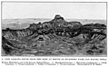
Angel Arch is the largest natural arch located within Canyonlands National Park, in San Juan County, Utah. Some consider it the most beautiful and spectacular arch in the park, if not the entire canyon country. It is situated in a side canyon of Salt Creek Canyon, in the Needles District of the park. Precipitation runoff from Angel Arch drains north into the nearby Colorado River via Salt Creek. A 29-mile round-trip hike to Angel Arch leads to a viewpoint, and an additional 0.75-mile trail scrambles up into the arch opening. The arch's descriptive name comes from its resemblance to an angel with wings folded, and standing with its back to the arch opening. Before this feature's name was officially adopted in 1963 by the U.S. Board on Geographic Names, it was called Pegasus Arch. The first ascent was made in June 1993, by John Markel and Kevin Chase.

Inclined Temple

Inclined Temple is a remote 7,150-foot elevation summit located in Zion National Park, in Washington County of southwest Utah, United States.

Owl Rock

Owl Rock is a 6,547-foot elevation sandstone summit located south of Monument Valley, in northeast Arizona. It is situated 7 miles (11 km) north of Kayenta on Navajo Nation land, and can be seen from Highway 163 perched on the east edge of Tyende Mesa, where it towers 1,000 feet above the surrounding terrain. Its nearest higher neighbor is Agathla Peak, 1.4 miles (2.3 km) to the east-northeast, on the opposite side of this highway. Precipitation runoff from this feature drains into El Capitan Wash, which is part of the San Juan River drainage basin. The first ascent of Owl Rock was made in April 1966 by Fred Beckey and Harvey Carter by climbing cracks on the west face, and then bolting up a smooth south nose to the summit. They employed 20 pitons and 14 bolts on this route called Warpath. The descriptive name stems from its uncanny resemblance to an owl when viewed from the east. This feature is known as Bee 'Adizí in Navajo language meaning "spindle", and this sacred place is considered to be a spindle left behind by the Holy People. A newer name for it is Tsé Ts'óózí, meaning "Slim Rock".

Pine Valley Peak

Pine Valley Peak is a 7,415-foot (2,260 m) mountain located in Zion National Park in Washington County, Utah, United States.

Airport Tower (Canyonlands)

Airport Tower is a 700-foot (210-meter) tall sandstone butte located in the Island in the Sky District of Canyonlands National Park, in San Juan County, Utah. It is situated 1.64 mile east of Washer Woman, which is a towering arch similar in height. Each are composed of Wingate Sandstone, which is the remains of wind-borne sand dunes deposited approximately 200 million years ago in the Late Triassic. The nearest higher neighbor is Monster Tower, 1.6 mi (2.6 km) to the west, Tiki Tower is one-half mile northwest, and Mesa Arch is situated 3.2 mi (5.1 km) to the west. A short hike to Mesa Arch provides the easiest view of Airport Tower. Access to this tower is via the four-wheel drive White Rim Road, which is another option to see Airport Tower. The top of this geological formation rises 1,400 feet above the road in less than one mile. Precipitation runoff from Airport Tower drains southeast into the nearby Colorado River via Buck and Lathrop Canyons. This geographical feature's name was officially adopted in 1986 by the U.S. Board on Geographic Names. It was so named because the rock formation resembles the appearance of an airport control tower.

Zeus and Moses Rock formations in Utah, United States

Zeus and Moses are a pair of 500-foot-tall (150 m) sandstone formations located in the Island in the Sky District of Canyonlands National Park, in San Juan County, Utah, United States. These rock towers' names refer to Zeus, a god in Greek mythology, and Moses, an important prophet in several religious traditions. Zeus and Moses are composed of Wingate Sandstone, which is the remains of wind-borne sand dunes deposited approximately 200 million years ago in the Late Triassic. This formation is situated in Taylor Canyon, 3 mi (4.8 km) north-northeast of Upheaval Dome. Access to the towers is via the four-wheel-drive White Rim Road, and a spur road into Taylor Canyon. The top of this geological formation rises 900 feet above the canyon floor at road's end, approximately one-half mile away. Precipitation runoff from Zeus and Moses drains into the nearby Green River via Taylor Canyon.

Cave Knoll

Cave Knoll is a 6,486-foot (1,977 m) summit located in Zion National Park, in Washington County of southwest Utah, United States. Cave Knoll, a formation composed of Navajo Sandstone, is situated in Cave Valley, 11.5 mi (18.5 km) northwest of Springdale, Utah. Its neighbors include Pine Valley Peak, 1.7 mi (3 km) to the northeast, Tabernacle Dome, 1.6 mi (3 km) to the south-southeast, and North Guardian Angel, 2.5 mi (4 km) to the east. Precipitation runoff from this mountain drains into tributaries of the Virgin River. Access to this peak is via the Kolob Terrace Road. This peak's name was officially adopted in 1934 by the U.S. Board on Geographic Names.

Chip and Dale Towers

Chip and Dale Towers are two 300-foot (91-meter) tall sandstone towers located in the Island in the Sky District of Canyonlands National Park, in San Juan County, Utah. Dale Tower rises to an elevation of 5,620 feet, whereas the lower Chip Tower is 5,420-feet. Airport Tower is set 2.5 mi (4.0 km) to the southwest, and Dead Horse Point State Park overlook is situated 4.5 mi (7.2 km) to the north-northeast. Chip and Dale Towers are an eroded fin composed of hard, fine-grained Wingate Sandstone, which is the remains of wind-borne sand dunes deposited approximately 200 million years ago in the Late Triassic. This Wingate Sandstone overlays a softer layer of the Chinle Formation. Access to the towers is via the four-wheel drive White Rim Road, and a scramble to reach the base. The top of the towers rise over 1,000 feet above the road in approximately one-half mile. Precipitation runoff from Chip and Dale Towers drains east to the nearby Colorado River.

Sixshooter Peaks

The Sixshooter Peaks are two iconic sandstone summits located in Bears Ears National Monument, in San Juan County of Utah, United States. The larger and higher North Sixshooter Peak rises to an elevation of 6,379 feet, whereas South Sixshooter Peak rises to 6,154 feet, with approximately 1.5 mile separation between the two. These buttes tower nearly 1,400 feet above the surrounding terrain, and are historic landmarks visible from State Route 211 between Newspaper Rock and the Needles District of Canyonlands National Park. They are situated 1.5 mile outside the boundary of the park, and four miles northwest of Bridger Jack Butte. Variant names for the peaks include "North Six-Shooter Peak", "South Six-shooter Peak", "Six Shooter Peaks", and "Six-shooter Peak". They are so named because of their resemblance to a pair of revolvers pointing skyward.

Bridger Jack Butte

The Bridger Jack Butte is a sandstone summit located in Bears Ears National Monument, in San Juan County of Utah, United States. This butte, which is set at the northern tip of namesake Bridger Jack Mesa, and above the confluence of Indian and Lavender Creeks, rises to an elevation of 5,890 feet, and towers over 700 feet above the surrounding terrain and floor of Lavender Canyon to its west. This landmark is situated four miles southeast of Sixshooter Peaks, and is visible from State Route 211 between Newspaper Rock and the Needles District of Canyonlands National Park. "Bridger Jack" was a Paiute medicine man.

Wild Horse Butte

Wild Horse Butte is a 5,760-foot (1,756-meter) elevation summit located in Goblin Valley State Park, in Emery County, Utah. Wild Horse Butte is situated 2.3 mi (3.7 km) west of Mollys Castle, and the top of this geological feature rises over 800 feet above its surrounding terrain, with precipitation runoff from Wild Horse Butte entering the Colorado River drainage basin. John C. Frémont's fifth expedition (1853–1854) stopped at Wild Horse Butte in January 1854, when Solomon Nunes Carvalho recorded a daguerreotype image of this butte.

Mollys Castle

Mollys Castle is a remote 5,265-foot (1,605-meter) elevation summit located near Goblin Valley State Park, in Emery County, Utah. Mollys Castle is situated 2.3 mi (3.7 km) east of Wild Horse Butte, and one-half mile outside the park's east boundary. The top of this magnificent butte rises 265 feet above its surrounding terrain. Precipitation runoff from Mollys Castle enters the Colorado River drainage basin.

Temple Mountain (Utah)

Temple Mountain is a remote 6,820-foot (2,080 m) mountain on the southeast flank of the San Rafael Swell in Emery County, Utah, United States.

Smithsonian Butte

Smithsonian Butte is a 6,780-foot (2,070 m) elevation summit located in the Canaan Mountain Wilderness of Washington County in southwest Utah, United States.

Eagle Crags

Eagle Crags is a 6,380-foot (1,940 m) elevation summit located in the Canaan Mountain Wilderness of Washington County in southwest Utah, United States.

Mount Garfield (San Juan County, Colorado)

Mount Garfield is a 13,074-foot-elevation mountain summit located in San Juan County, Colorado, United States. It is situated eight miles south of the community of Silverton, in the Weminuche Wilderness, on land managed by San Juan National Forest. It is part of the San Juan Mountains range which is a subset of the Rocky Mountains of North America. Precipitation runoff from the mountain drains into tributaries of the Animas River. The peak can be seen from U.S. Route 550 and the Durango and Silverton Narrow Gauge Railroad. Topographic relief is significant as the west aspect rises over 4,300 feet (1,310 meters) above the river and railway in approximately one mile. It is set six miles west of the Continental Divide, one mile west of Electric Peak, and three miles east-southeast of Snowdon Peak.

Snowdon Peak Mountain in Colorado, United States

Snowdon Peak is a 13,077-foot-elevation mountain summit located in San Juan County, Colorado, United States. It is situated seven miles south of the community of Silverton, in the Weminuche Wilderness, on land managed by San Juan National Forest. It is part of the San Juan Mountains range which is a subset of the Rocky Mountains of North America, and is set nine miles west of the Continental Divide. Topographic relief is significant as the east aspect rises 4,300 feet (1,310 meters) above the Animas River in approximately 1.5 mile. Neighbors include Mount Garfield three miles to the east-southeast, and Twilight Peak, which is the nearest higher peak, 3.7 miles to the south-southwest. This mountain can be seen from U.S. Route 550. The mountain is named after Snowdon, the highest mountain in Wales.

References

  1. 1 2 3 4 5 6 7 "Window Blind Peak - 7,030' UT". listsofjohn.com. Retrieved 2020-11-20.
  2. "Window Blind Peak". Geographic Names Information System . United States Geological Survey . Retrieved 2020-11-20.
  3. 1 2 "Window Blind Peak, Utah". Peakbagger.com. Retrieved 2020-11-20.
  4. "First Ascent Timeline". DesertTowersBook.
  5. Mexican Mountain WSA, Utah BLM Statewide Wilderness Draft Environmental Impact Statement, Volume VI, East-Central Region, page 15.
  6. Peel, M. C.; Finlayson, B. L.; McMahon, T. A. (2007). "Updated world map of the Köppen−Geiger climate classification". Hydrol. Earth Syst. Sci. 11. ISSN   1027-5606.