Atebubu-Amantin Municipal District

Last updated

Atebubu-Amantin Municipal District
Municipal District
Districts of the Bono East Region (2019).png
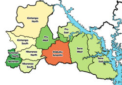
Districts of Bono East Region
Ghana adm location map.svg
Red pog.svg
Atebubu-Amantin Municipal District
Location of Atebubu-Amantin Municipal District within Bono East Region
Coordinates: 7°38′N1°4′W / 7.633°N 1.067°W / 7.633; -1.067
CountryFlag of Ghana.svg  Ghana
Region Bono East Region
Capital Atebubu
Government
  Municipal Chief ExecutiveEdward Owusu
Population
 (2021 Census)
  Total
144,947 [1]
  Ethnicity
Akan people
Time zone UTC+0 (GMT)

Atebubu-Amantin Municipal District is one of the eleven districts in Bono East Region, Ghana. [2] [3] Originally it was formerly part of the then-larger Atebubu District on 10 March 1989, until the northern part of the district was split off to create Pru District on 12 November 2003 (effectively 18 February 2004); [4] thus the remaining part has been renamed as Atebubu-Amantin District, [5] which it was later elevated to municipal district assembly status on 15 March 2018 to become Atebubu-Amantin Municipal District. [6] The municipality is located in the east central part of Bono East Region and has Atebubu as its capital town.

Contents

District Substructure

As of 2018, the district comprises eight (8) zonal councils. These were: Atebubu, Amantin, New Konkrompe, Jato Zongo, Akokoa, Nyomoase, Kumfia/Fakwasi and Garadima. [6]

Population

According to the 2010 population and housing census of Ghana the population of the Atebubu-Amantin District was 105,938. 50.7% of the population was of male and females made up 49.3% of the population. Majority of the population reside in the two principal towns of Atebubu and Amantin. [6]

List of settlements

Settlements of Atebubu-Amantin District
No. Settlement PopulationPopulation year
1Abuo
2Ahonto
3Akokoa
4Asempaneye
5 Atebubu
6Dobidi Nkwanta
7Bresoano
8Dentenso
9Fante New Town
10Forty-four
11Garadima
12Lailai
13Masuo
14Mem
15Mempeasem Boniafo
16New Kronkrompe
17Nkwanta
18Nyomoase
19Old Kronkrompe
20Sawankyi-Afrefreso
21Seneso
22Tintale
23primukyea
24Watro
25Yawbraso
26Yawtuffour

Amantin, Jato Zongo, Kumfia, Fakwasi, Abamba

Sources

References

  1. Ghana: Administrative Division
  2. Staff, BA News (2019-02-13). "The 11 Districts of The Bono East Region". BA NEWS. Archived from the original on 2021-04-18. Retrieved 2020-07-03.
  3. "Amantin starch factory to start operation July". Graphic Online. Retrieved 2021-05-16.
  4. THE COMPOSITE BUDGET OF ATEBUBU AMANTIN DISTRICT ASSEMBLY FOR THE 2015-2017 FISCAL YEAR (PDF). Atebubu-Amantin District Assembly. 2015. pp. 3, 4.
  5. "Nineteen New Districts Created". ghanaweb.com. 20 November 2003. Archived from the original on 2 February 2011. Retrieved 21 February 2006.
  6. 1 2 3 THE COMPOSITE BUDGET OF ATEBUBU AMANTIN DISTRICT ASSEMBLY FOR THE 2020-2023 FISCAL YEAR (PDF). Atebubu-Amantin District Assembly. 2015. pp. 3, 4.

7°38′N1°4′W / 7.633°N 1.067°W / 7.633; -1.067