Attu Station, Alaska

Last updated

Attu Station, Alaska
CDP
Attu sat.jpg
Attu Island with land area of 892.795 km2 (344.71 sq mi)
AKMap-doton-AttuStation.PNG
Location of Attu Station, Alaska
Coordinates: 52°50′47″N173°11′10″E / 52.84639°N 173.18611°E / 52.84639; 173.18611
Country United States
State Alaska
Census Area Aleutians West
Government
   State senator Lyman Hoffman (D) [1]
   State rep. Bryce Edgmon (I)
Area
[2]
  Total143.62 sq mi (371.97 km2)
  Land142.54 sq mi (369.17 km2)
  Water1.08 sq mi (2.80 km2)
Population
 (2020)
  Total0
  Density0.00/sq mi (0.00/km2)
Time zone UTC-10 (Hawaii-Aleutian (HST))
  Summer (DST) UTC-9 (HDT)
ZIP code
[3]
Area code 907
FIPS code 02-04670

Attu Station is a census-designated place (CDP) located on Attu Island in the Aleutians West Census Area in the U.S. state of Alaska. The population was 21 at the 2010 census, [4] consisting entirely of coast guard personnel who resided and worked at Casco Cove Coast Guard Station, but left the island when the station was closed in August 2010, leaving it uninhabited. LORAN Station Attu had provided a navigational signal for mariners of the North Pacific since the 1970s. [4] [5] [6]

Contents

Although it is relatively the westernmost point in the United States, Attu Station is technically one of the easternmost points, located at 52°50′47″N173°11′10″E / 52.84639°N 173.18611°E / 52.84639; 173.18611 , opposite the 180th meridian and International Date Line from the rest of the United States. (See Extreme Points of the United States, although Attu is not listed there).

History

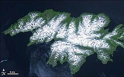
After the Japanese invasion of Attu Island and the battle to retake it, the United States government constructed a LORAN station on the southern tip of the island, at Theodore Point. The equipment to build the station came from Holtz Bay and was ferried on barges and landing craft to Baxter Cove, about 1 mi (1.6 km) east of the station. Bulldozers were used to cut a road from Baxter Cove to Theodore Point.

In 1960, the station was moved to Casco Cove, near the former United States Navy base at Massacre Bay. Later, it was moved to Massacre Bay. LORAN Station Attu ceased transmission of the LORAN signal on February 8, 2010, and the Russian-American signal ceased on August 1, 2010.

Geography

According to the U.S. Census Bureau, the CDP has a total area of 143.6 square miles (371.9 km2), for which 142.6 square miles (369.3 km2) of it is land and 1.1 square miles (2.8 km2) of it (0.75%) is water.

Demographics

Historical population
CensusPop.Note
1980 28
2000 20
2010 215.0%
2020 0−100.0%
U.S. Decennial Census [7]

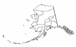
Attu (Naval) Station first appeared on the 1980 U.S. Census as "Attu", a census-designated place (CDP). [8] It did not return on the 1990 census. [9] The name was changed to Attu Naval Station and redesignated a CDP in 2000. [10] It appeared lastly on the 2010 census, [11] just before the closure of the station in August that year and the departure of its remaining residents.

At the 2000 census there were 20 people, 0 households, and 0 families in the CDP. The population density was 0.1 inhabitants per square mile (0.039/km2). There were 0 housing units at an average density of 0.0 per square mile (0/km2). The racial makeup of the CDP was 18 White, 1 from other races, and 1 from two or more races. Five of the population were Hispanic or Latino of any race. [4] The age distribution was 7 from 18 to 24, 12 from 25 to 44, and 1 from 45 to 64. The median age was 30 years. There were 19 men and one woman.

Males had a median income of $26,250, which is the same as for females. The per capita income for the CDP was $26,964. None of the population was below the poverty line.

As noted above, however, due to the closure of the station the community is presently uninhabited.

Related Research Articles

<span class="mw-page-title-main">Aleutians West Census Area, Alaska</span> Census area in Alaska, United States

Aleutians West Census Area is a census area located in the U.S. state of Alaska. As of the 2020 census, the population was 5,232, down from 5,561 in 2010.

<span class="mw-page-title-main">Nikolski, Alaska</span> CDP in Alaska, United States

Nikolski is a census-designated place (CDP) on Umnak Island in Aleutians West Census Area, Alaska, United States. The population was 39 at the 2020 census, up from 18 in 2010. Nikolski is on Nikolski Bay, off the southwest end of the island. It is 116 air miles west of Unalaska, and 900 air miles from Anchorage. Residents are known as Unangan, and Aleut is spoken in most of the remaining homes.

<span class="mw-page-title-main">Halibut Cove, Alaska</span> Census-designated place in Alaska, United States

Halibut Cove is a census-designated place (CDP) in Kenai Peninsula Borough, Alaska, United States. The population was 76 at the 2010 census, up from 35 in 2000.

<span class="mw-page-title-main">Chase, Alaska</span> CDP in Alaska, United States

Chase is a census-designated place (CDP) in Matanuska-Susitna Borough, Alaska, United States. Located 9.2 miles north from Talkeetna, it is part of the Anchorage, Alaska Metropolitan Statistical Area. The population was 19 at the 2020 census, down from 34 in 2010.

<span class="mw-page-title-main">Susitna, Alaska</span> Census-designated place in Alaska, United States

Susitna is a census-designated place (CDP) in Matanuska-Susitna Borough, Alaska, United States. It is part of the Anchorage Metropolitan Area. As of the 2020 census, the population of the CDP was 11.

<span class="mw-page-title-main">Port Clarence, Alaska</span> CDP in Alaska, United States

Port Clarence is a census-designated place (CDP) in the Nome Census Area of Alaska. The population was 0 at the 2020 census, down from 24 in 2010. It is located on the spit separating Port Clarence Bay from the Bering Strait.

<span class="mw-page-title-main">Point Lay, Alaska</span> CDP in Alaska, United States

Point Lay is a census-designated place (CDP) in North Slope Borough, Alaska, United States. At the 2020 census the population was 330, up from 189 in 2010.

<span class="mw-page-title-main">Coffman Cove, Alaska</span> City in Alaska, United States

Coffman Cove is a city in Prince of Wales-Hyder Census Area, Alaska, in the United States. Located on Prince of Wales Island, its population was 176 at the 2010 census, down from 199 in 2000.

<span class="mw-page-title-main">Cube Cove, Alaska</span> Unincorporated community in the state of Alaska, United States

Cube Cove was an unincorporated community and census-designated place on the northwestern side of Admiralty Island in the Hoonah-Angoon Census Area of the U.S. state of Alaska. The population was 72 at the 2000 United States Census, but it was not included in the 2010 census.

<span class="mw-page-title-main">Elfin Cove, Alaska</span> Census-designated place in Alaska, United States

Elfin Cove is a census-designated place (CDP) near the northwestern corner of Chichagof Island in Hoonah-Angoon Census Area, Alaska, United States. The population was 20 at the 2010 census, down from 32 at the 2000 census.

<span class="mw-page-title-main">Alcan Border, Alaska</span> Census-designated place in Alaska, United States

Alcan Border, also known as Port Alcan, is a census-designated place in the Southeast Fairbanks Census Area in the U.S. state of Alaska. Part of the Unorganized Borough, Alcan Border is the site of the Alcan - Beaver Creek Border Crossing, the main U.S. port of entry for persons arriving in Alaska by road. The population was 33 at the 2010 census, up from 21 in 2000.

Willow Creek is a census-designated place (CDP) in Copper River Census Area, Alaska, United States. At the 2020 census the population was 190, down from 191 in 2010.

<span class="mw-page-title-main">Lemon Cove, California</span> Census designated place in California, United States

Lemon Cove is a census-designated place (CDP) in the San Joaquin Valley in Tulare County, California, United States. The population was 308 at the 2010 census, up from 298 at the 2000 census.

<span class="mw-page-title-main">Plantation Island, Florida</span> Census-designated place in Florida

Plantation Island is a census-designated place (CDP) in Collier County, Florida, United States. The population was 163 at the 2010 census. It is part of the Naples–Marco Island Metropolitan Statistical Area.

<span class="mw-page-title-main">Fruit Cove, Florida</span> CDP in Florida, United States

Fruit Cove is a census-designated place (CDP) in St. Johns County, Florida, United States. It is located in the community of St. Johns. The population was 32,143 at the 2020 census.

<span class="mw-page-title-main">Attu Island</span> Uninhabited island in the Aleutian Islands, Alaska, United States

Attu is an island in the Near Islands. It is the westernmost point of the U.S. state of Alaska. The island became uninhabited in 2010, making it the largest uninhabited island that is part of the United States politically.

<span class="mw-page-title-main">Casco Cove Coast Guard Station</span> Airport in Attu Island, Alaska

Casco Cove Coast Guard Station was a military facility and private use airfield on Attu Island, one of the Aleutian Islands in the U.S. state of Alaska. Owned by the United States Coast Guard, Casco Cove CGS is located 1,481 miles (2,383 km) west of Anchorage, Alaska. Also known as LORAN Station Attu, the facility was closed on August 27, 2010, but the airfield remains available for emergency use.

<span class="mw-page-title-main">Casco (CDP), Maine</span> Census-designated place in Maine, United States

Casco is a census-designated place (CDP) in the town of Casco in Cumberland County, Maine, United States. The population of the CDP was 587 at the 2010 census. It is part of the Portland–South Portland–Biddeford, Maine Metropolitan Statistical Area.

<span class="mw-page-title-main">Littlejohn Island</span> Census-designated place in Maine, United States

Littlejohn Island is an island and census-designated place (CDP) in the town of Yarmouth in Cumberland County, Maine, United States. The population of the CDP was 118 at the 2010 census.

<span class="mw-page-title-main">Dover-Foxcroft (CDP), Maine</span> CDP in Maine, United States

Dover-Foxcroft is a census-designated place (CDP) in the town of Dover-Foxcroft in Piscataquis County, Maine, United States. The population was 2,592 at the 2000 census.

References

  1. "Senator Lyman Hoffman". Alaska Senate Majority. Alaskasenate.org. Archived from the original on April 8, 2020. Retrieved November 16, 2019.
  2. "2020 U.S. Gazetteer Files". United States Census Bureau. Retrieved October 29, 2021.
  3. "Attu Station AK ZIP Code". zipdatamaps.com. 2023. Retrieved June 16, 2023.
  4. 1 2 3 "U.S. Census website". United States Census Bureau . Retrieved January 31, 2008.
  5. Home page for USCG Loran Station Attu (modified July 23, 2007)
  6. "Alaska Coast Guard says goodbye to its last LORAN station". KUCB News. Unalaska Community Broadcasting. August 27, 2010. Archived from the original on November 19, 2018. Retrieved March 25, 2013.
  7. "Census of Population and Housing". Census.gov. Retrieved June 4, 2015.
  8. "Characteristics of the Populations - Number of Inhabitants - Alaska" (PDF). United States Census Bureau. May 1982.
  9. "1990 Census of Population and Housing - Summary Social, Economic, and Housing Characteristics - Alaska" (PDF). United States Census Bureau. Archived from the original (PDF) on February 23, 2014.
  10. U.S. Census Bureau. "2000 Census of Population and Housing - Alaska" (PDF). Archived from the original (PDF) on March 18, 2021. Retrieved October 14, 2019.
  11. U.S. Census Bureau (June 2012). "2010 Census of Population and Housing - Alaska" (PDF). U.S. Government Printing Office. Archived from the original (PDF) on February 24, 2014.