Auraria, Denver

Last updated
Auraria
Settlement (historic) Neighborhood (current)
9thstreethistoricpark.JPG
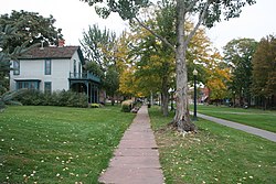
The Ninth Street Historic Park in Denver, Colorado
Etymology: Auraria, Georgia
Auraria, Denver
Coordinates: 39°44′34″N105°00′19″W / 39.7428°N 105.0052°W / 39.7428; -105.0052 (Auraria)
Country United States of America
State Colorado
City Denver
Founded by William Greeneberry Russell
Population
 (2010) [1]
  Total705
ZIP Codes
80204

Auraria was a small mining settlement in the Kansas Territory in the United States. Today it survives in its original location as a neighborhood of Denver, Colorado, south of the confluence of Cherry Creek and the South Platte River.

Contents

Geography

Auraria is located in central Denver. It is just west of downtown Denver and is shaped roughly like a triangle. It borders Colfax Avenue on the south, Cherry Creek to the northeast, and South Platte River to the northwest.

History

On October 3, 1858, a group of Georgia prospectors led by Green Russell established the townsite of Auraria south of Cherry Creek near the Cherry Creek Diggings, over a month before a group of Kansas Territory speculators led by William Larimer established the rival Denver City on the other side of Cherry Creek. [2] [3] Henry Allen, a surveyor, laid the town platte and was Auraria town company's first president. [4] The town was named for the gold mining settlement of Auraria, Georgia. On October 29, Charles H. Blake and A.J. Williams opened a mercantile business out of wagons in Auraria.

Henry Allen was the first postmaster of Auraria. [5] On January 18, 1859, the first post office in the future State of Colorado opened in Auraria. On, April 15, 1859, ten delegates from six communities in the Pike's Peak Country met in convention at Dick Wooton’s store in Auraria to pass resolutions to organize a Provisional State of Jefferson. On April 23, William Byers published the first edition of the Rocky Mountain News, the Rocky Mountain region's first newspaper, at Auraria. At an election on September 24, voters rejected the proposed state, but on October 24, voters approved the establishment of the Provisional Government of the Territory of Jefferson.

Auraria ceased to exist as a separate town on December 3, 1859, when the Jefferson Territory granted a charter to the consolidated City of Denver, Auraria, and Highland, which would come to be known as just Denver City, the territorial capital and seat of Arrappahoe County. The Jefferson Territory was itself superseded on February 28, 1861, when U.S. President James Buchanan signed An Act to provide a temporary Government for the Territory of Colorado. [6]

Auraria suffered a devastating flood on May 19, 1864. In response, many businesses left the neighborhood for Denver proper. Some speculate that Auraria never truly recovered from this event. [7]

In the 1960s and 1970s, Auraria became the focal point for urban renewal in Denver. It was decided that the neighborhood would be converted to a campus to house the University of Colorado Denver, Metropolitan State University, and the Community College of Denver. Demolition of old Auraria began on March 10, 1973. [8] A few buildings from old Auraria are still standing today.

The name "Auraria" survives in Denver as the neighborhood along the west bank of Cherry Creek to the east bank of the South Platte River, bordered on the south by Colfax Avenue. Auraria is easily confused with, but is entirely distinct from the City of Aurora, Denver's neighbor some six miles to the east.

The River Mile redevelopment

In 2018 the City and County of Denver approved a rezoning development agreement for 58 acres of Auraria. The "River Mile" would replace Elitch Gardens (most of the part of Auraria adjacent to the South Platte River) in one of the largest redevelopment projects in Denver's history. [9] As of 2024 the project is still in the planning stages. [10]

Arts and culture

Attractions

Sports

Auraria contains the Ball Arena arena, home of the Colorado Avalanche, Denver Nuggets, and Colorado Mammoth, as well as the venue of concerts and other events.

Education

The neighborhood of Auraria is dominated by the Auraria Campus, which is home to three institutions of higher learning: University of Colorado Denver (CU Denver), Metropolitan State University of Denver (MSU Denver), and Community College of Denver (CCD). Vestiges of the old neighborhood remain, however, in the Ninth Street Historic Park on the campus. The three institutions occupy the bulk of the Auraria Neighborhood, so there is very little permanent residence. The schools mainly serve commuter students, though housing has recently been developed at Campus Village Apartments (UCD), Auraria Student Lofts, and Regency Student Housing.

Media

There are two student newspapers that are published in Auraria. The University of Colorado Denver's newspaper is called the "CU Denver Sentry" and Metropolitan State University's newspaper is "Met Media". [11] [12]

Transportation

Auraria is serviced by the Regional Transportation District. It has two light rail stations within its boundaries: the Colfax at Auraria station and the Auraria West station.

See also

Related Research Articles

<span class="mw-page-title-main">Pike's Peak gold rush</span> Nineteenth-century gold-prospecting frenzy in Colorado, US

The Pike's Peak gold rush was the boom in gold prospecting and mining in the Pike's Peak Country of western Kansas Territory and southwestern Nebraska Territory of the United States that began in July 1858 and lasted until roughly the creation of the Colorado Territory on February 28, 1861. An estimated 100,000 gold seekers took part in one of the greatest gold rushes in North American history.

<span class="mw-page-title-main">Arapahoe County, Colorado</span> County in Colorado, United States

Arapahoe County is a county located in the U.S. state of Colorado. As of the 2020 census, its population was 655,070, making it the third-most populous county in Colorado. The county seat is Littleton, and the most populous city is Aurora. The county was named for the Arapaho Native American tribe, who once lived in the region.

<span class="mw-page-title-main">Colorado Territory</span> Historic region of the US, 1861 to 1876

The Territory of Colorado was an organized incorporated territory of the United States that existed from February 28, 1861, until August 1, 1876, when it was admitted to the Union as the 38th State of Colorado.

<span class="mw-page-title-main">LoDo, Denver</span> Unofficial neighborhood in Denver, Colorado

LoDo is an unofficial neighborhood in Denver, Colorado, and is one of the oldest places of settlement in the city. It is a mixed-use historic district, known for its nightlife, and serves as an example of success in urban reinvestment and revitalization. The current population is approximately 21,145.

<span class="mw-page-title-main">William Larimer Jr.</span> American politician

William Larimer Jr. was an American businessman, investor, militia general, and politician who is best known as the founder of Denver, Colorado, in 1858. Larimer often went by "General Larimer", having acquired the title in the Pennsylvania Militia.

<span class="mw-page-title-main">Auraria Campus</span> Academic campus in Denver, Colorado, home to three higher education institutions

Auraria Campus is an educational facility located near downtown Denver, Colorado in the United States. The campus houses facilities of three separate universities and colleges: the University of Colorado Denver, Community College of Denver (CCD), and Metropolitan State University of Denver. In 2017, there were approximately 54,812 students between the three schools, with rapid growth projected over the following few years. However, due to the Covid-19 pandemic and declining enrollment, the collective student population in 2022 was approximately 38,000, with an additional 5,000 faculty and staff.

<span class="mw-page-title-main">Jefferson Park, Denver</span>

Jefferson Park is a neighborhood and public park that overlooks Downtown Denver, Colorado from its perch across Interstate 25 (I-25). It is located in the area that is called North Denver. Views east from Jefferson Park take in Elitch Gardens Theme Park, The Children's Museum, Denver's Downtown Aquarium, Pepsi Center, the REI flagship store and other attractions in Downtown's Central Platte Valley. Downtown Denver and the Central Platte Valley are quickly accessed from Jefferson Park, using the 23rd Avenue overpass on I-25 and Water Street. In addition, the Light Rail C-Line is located by Empower Field at Mile High in the southern part of the neighborhood.

The History of Denver details the history of the City and County of Denver, Colorado, the United States from its founding in 1858 to modern-day. Ever since the gold rush, Denver has been Colorado’s gateway and major metropolis. With its location at the intersection of the plains and the mountains, its people and institutions have tied together the sections of the state and served as a point of contact between Colorado and the wider world. As the state’s political capital and largest city, Denver has been the natural center for decision-making. New programs and ideas have typically spread outward through the public agencies and private organizations that have Denver headquarters.

<span class="mw-page-title-main">Highland, Denver</span>

Highland is a distinct city-center neighborhood in Denver, Colorado, United States, bounded by West 38th Avenue to the north, a Union Pacific Railroad line on the east, the South Platte River to the southeast, Speer Boulevard on the south, and Federal Boulevard on the west. The Highlands is sometimes used to refer to two separate city-center neighborhoods in Denver; Highland and West Highland, although the two neighborhoods are distinct. Highland and West Highland are both in the area that is referred to as the Northside. Highland is located immediately northwest of downtown. Note that the Highland neighborhood association has a slightly different definition with the easternmost boundary stopping at I-25. And the West Highland neighborhood to the immediate west of Highland, with the borders of 38th and 29th Avenues on the north and south and Federal and Sheridan Boulevards on the east and west. To distinguish between its immediately adjacent neighbor, West Highland, Highland is sometimes referred to as East Highland, Lower Highland or LoHi. The two together are casually called "the Highlands," a term which often falsely encompasses other Northwest Denver neighborhoods such as Jefferson Park, Sunnyside and Berkeley. Realtors have particularly pushed the inclusion of the recently gentrified Berkeley, located directly north of West Highland, as part of the Highlands, sometimes going so far as to refer to Berkeley and parts of Sunnyside as the "Upper Highlands". To add further confusion, within the Highlands neighborhoods there are several historic designations of various degrees, including Potter Highlands, Scottish Highlands and Highlands Park.

<span class="mw-page-title-main">Street system of Denver</span> Dual street grid system in Denver, CO

The oldest part of Denver, Colorado, now the neighborhoods of Auraria Campus, LoDo, much of downtown, and Five Points, is laid out on a grid plan that is oriented diagonal to the four cardinal directions. The rest of the city, including the eastern part of downtown, is laid out primarily on a grid oriented to the cardinal directions. In this larger grid, from east to west, there are generally 16 city blocks per mile, except between Zuni Street and Lowell Boulevard in west Denver. From north to south, there are typically eight blocks per mile, although there are many areas with more blocks per mile. Addresses follow a decimal system, with addresses advancing by one hundred at each cross street.

<span class="mw-page-title-main">Lincoln Park, Denver</span> Neighborhood in Denver, Colorado, United States of America

Lincoln Park is a neighborhood and public park close to downtown Denver, Colorado and the location of the Art District on Santa Fe. The neighborhood is one of Denver's oldest and is just to the south of the area where Denver was first settled in the 1850s. Many houses date from about 1900. The neighborhood is sometimes called "La Alma/Lincoln Park" or the West Side.

<span class="mw-page-title-main">Outline of Colorado</span> Overview of and topical guide to Colorado

The following outline is provided as an overview of and topical guide to the U.S. state of Colorado:

<span class="mw-page-title-main">W Line (RTD)</span> Light rail line in the Denver metropolitan area

The W Line, also called the West Rail Line, is a light rail line in Denver, Lakewood, and Golden, Colorado, United States. The W Line was the first part of FasTracks to break ground, on May 16, 2007. The line, the only line to traverse the West Corridor, opened for service on Friday, April 26, 2013.

Lewis Ralston was an American placer gold prospector from Georgia who made the first recorded discovery of gold in the Rocky Mountain region.

<span class="mw-page-title-main">University of Colorado Denver</span> Public university in Denver, Colorado, US

The University of Colorado Denver is a public research university located in downtown Denver, Colorado. It is part of the University of Colorado system. Established in 1912 as an extension of the University of Colorado Boulder, CU Denver attained university status and became an independent institution in 1973. CU Denver is the largest research university in Colorado, and is classified among R1: Doctoral Universities – Very High Research Activity. The university's graduate programs award more master's degrees than any other institution in the state, serving roughly 5,000 students annually. CU Denver makes up one-third of the Auraria Campus in downtown Denver, along with the Metropolitan State University of Denver and the Community College of Denver.

<span class="mw-page-title-main">John C. Moore (Denver mayor)</span> American politician

John Courtney Moore was an American politician and journalist who served as the first mayor of Denver from 1859 to 1861. He was an early settler of Denver, while the area was still a territory of the United States. Moore was a newspaper journalist and publisher, working on papers in Denver, St. Louis, Kansas City, and Pueblo, Colorado. During the American Civil War, he was a judge adjutant general and colonel in the Confederate States Army.

The following is a timeline of the history of the city of Denver, Colorado, United States, from its founding in 1858 to the present.

Henry Allen was an American pioneer and politician. He served in the United States Army before settling in Council Bluffs, where he was a postmaster. He was at the front of the Pike's Peak Gold Rush, arriving in Denver of the Kansas Territory in October 1858. He prospected for gold and was the first official postmaster of the Pikes Peak region. As a surveyor, he helped establish Auraria, Highland, which later came part of the city of Denver. He was a founder of a company that diverted water from the South Platte River through irrigation ditches. He held the first meeting in his cabin for what became the Auraria Masonic Lodge. He was a delegate from Auraria for the first Constitutional Convention of the Jefferson Territory. Allen and his wife lived in mining towns in Colorado, Idaho, and Montana. Due to poor health, Henry and Susan Allen moved to California, where Allen died in 1871.

The River Mile is a planned 62-acre (250,000 m2) master-planned, mixed-use community in Denver, Colorado. The site is currently home to Elitch Gardens Theme Park, an amusement park and water park dating back to its current location in 1995. The development gets its name from the adjacent South Platte River, of which the development runs about 1 mile (1.6 km) along the river. The project largely follows a New Urbanist design, emphasizing the "human-scale" development over auto-centric development. The project would be complimented by more mixed-use redevelopments occurring around the Ball Arena, Mile High Stadium, and Auraria Campus, all of which emphasize similar goals as The River Mile.

References

  1. "Census Neighborhood Demographics (2010)". City of Denver.
  2. "An Inventory of the Records of the Auraria Town Company" (PDF). Colorado Historical Society. February 1993. Retrieved April 24, 2021.
  3. Summers, Jodi (2003). Auraria: From Neighborhood to Campus (PDF). Denver: University of Colorado at Denver. p. 32.
  4. Bancroft, Hubert Howe (1890). History of Nevada, Colorado, and Wyoming, 1540-1888. History Company. pp. 367, 373–374.
  5. Bromwell, Henrietta E. (1926). "Fifty-niners' Directory- Colorado Argonauts of 1858-1859, 2 volumes" (PDF). Denver Public Library.
  6. Thirty-sixth United States Congress (February 28, 1861). "An Act To provide a temporary Government for the Territory of Colorado" (PDF). Retrieved November 16, 2020.
  7. Goodstein, Phil (2015). How the West Side Won: The History of West Denver. Denver: New Social Publications. p. 11. ISBN   978-0986074813.
  8. Goodstein (2015). How the West Side Won. p. 92.
  9. "The River Mile Rezoning Development Agreement". Denver City Council. City and County of Denver. Retrieved 31 July 2024.
  10. Harris, Kyle. "Downtown Denver's massive expansion into Kroenke's Ball Arena parking lots heads to City Council". Denverite. Dendrite. Retrieved 31 July 2024.
  11. "My Met Media".
  12. "CU Denver Sentry".