Related Research Articles
The Jones Mountains are an isolated group of mountains, trending generally east–west for 27 nautical miles, situated on the Eights Coast, Ellsworth Land, Antarctica, about 50 nautical miles south of Dustin Island.

Stromness Bay is a bay 3 miles (4.8 km) wide, entered between Cape Saunders and Busen Point on the north coast of South Georgia. Stromness Bay, like Leith Harbour takes its name from a location in Scotland, Stromness, on the Orkney Mainland. This is partially because both places called Stromness were whaling centres. The headland forming the southeast side of the entrance to Stromness Bay is named Busen Point. Bucentaur Rock lies close northeast of Busen Point.

Cheapman Bay is a bay 4 miles (6.4 km) wide, indenting the south coast of South Georgia close west of King Haakon Bay. The name Cheapman Strand was given to a feature in this vicinity by an American sealing expedition which visited South Georgia in 1877–78. The name was recorded as Chapman Strand and applied to this bay by Matthews in 1931. Langestrand has been used locally for the beach at the head of the bay and appeared for the bay itself on a British Admiralty chart of 1931. However, the South Georgia Survey, 1951–52, reported that "Langestrand" is a descriptive term, not a placename, and is applied by sealers to at least four other beaches in South Georgia. To avoid confusion, the name Cheapman Bay has been approved for this feature and all other names rejected.
You may be looking for Undine Harbour in the north west of South Georgia
Mount Brooker is a mountain, 1,880 metres (6,170 ft) high, standing at the head of Webb Glacier and forming the last major summit in the southeast part of the Allardyce Range of South Georgia. The feature was identified as "Pic" or "Pikstock" by the German group of the International Polar Year Investigations, 1882–83. It was first climbed in 1955 by Ian M. Brooker, for whom it is named, and E.C. Webb, members of the British South Georgia Expedition, 1954–55, led by George Sutton.
Tyrrell Glacier is a glacier flowing north into the head of Moraine Fjord where it joins Harker Glacier, on the north coast of South Georgia.

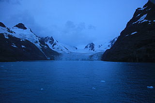
Moraine Fjord is an inlet 3.5 nautical miles long with a reef extending across its entrance, forming the west head of Cumberland East Bay, South Georgia. It was charted by the Swedish Antarctic Expedition under Otto Nordenskjöld, 1901–04, who so named it because of the large glacial moraine at its entrance.
Ducloz Head is a headland which forms the northwest side of the entrance to Undine South Harbour on the south coast of South Georgia. It was first charted in 1819 by a Russian expedition under Fabian Gottlieb von Bellingshausen. It was named by the UK Antarctic Place-Names Committee, following a survey by the South Georgia Survey, 1951–52, for Le Sieur Ducloz Guyot, a passenger in the Spanish vessel León, which sighted South Georgia in 1756.
Hestesletten is a glacial plain between the Hamberg Lakes and Cumberland East Bay, South Georgia. It is covered with tussock and is almost 2 miles (3.2 km) long in a northeast–southwest direction and 0.75 miles (1.2 km) wide. It is, along with Salisbury Plain, one of the few substantial flat areas on the island.

Busen Point or Busen Peninsula is a headland forming the southeast side of the entrance to Stromness Bay, on the north coast of South Georgia island. It lies on the Lewin Peninsula in between Stromness Bay and Cumberland West Bay.

Hamberg Glacier is a glacier which flows in an east-northeasterly direction from the northeast side of Mount Sugartop to the west side of the head of Moraine Fjord, South Georgia. It was charted by the Swedish Antarctic Expedition, 1901–04, under Otto Nordenskiöld, who named it for Axel Hamberg, a Swedish geographer, mineralogist and Arctic explorer.
Risting Glacier is a glacier, 4.5 nautical miles (8 km) long, lying north of Jenkins Glacier and flowing southeast into the head of Drygalski Fjord in the south part of South Georgia. Surveyed by the South Georgia Survey (SGS) under Duncan Carse in the period 1951–57, and named by the United Kingdom Antarctic Place-Names Committee (UK-APC) for Sigurd Risting (1870-1935), Norwegian whaling historian; secretary of Norsk Hvalfangerforening, 1918–35, and editor of Norsk Hvalfangst-Tidende, 1922–35. The German Antarctic Expedition under Wilhelm Filchner, 1911–12, named Drygalski Fjord and this glacier for Erich von Drygalski, leader of the German Antarctic Expedition, 1901–03, but the name for the glacier did not survive. A number of features in Antarctica, including Drygalski Glacier, are named for Drygalski.
Bore Valley is a valley that is 0.7 nautical miles (1.3 km) long in a north–south direction, extending from Lewis Pass to Grytviken in Cumberland Bay, South Georgia. It was first surveyed and named "Bores Dal" by the Swedish Antarctic Expedition (SwedAE) under Otto Nordenskiöld, 1901–04, but the form Bore Valley has since become established. The discovery by J. Gunnar Andersson, of the SwedAE, of numerous traces of a former ice covering, proving that ice had once filled the entire valley, led to the name. "Bore" is the Swedish word for Boreas, the Greek god of the north wind. Maidalen, to the north of Lewis Pass, was originally considered to be a part of Bore Valley but has since been determined to be a separate valley.
Neighbour Peak is a peak rising 1 nautical mile (1.9 km) west of Pirner Peak at Royal Bay, South Georgia. The British Combined Services Expedition, 1964–65, identified this feature as "Nachbar", the name used by the German expedition under Schrader, 1882–83. The United Kingdom Antarctic Place-Names Committee (UK-APC) recommended in 1971 that "Nachbar" be used in the English form Neighbour and the descriptive term peak be added to it.
Pirner Peak is a peak 0.7 nautical miles (1.3 km) northwest of Pirner Point, Royal Bay, South Georgia. Surveyed by the German group of the International Polar Year Investigations, 1882–83, and named by them for Captain Pirner of the expedition ship Moltke.
Pirner Point is a point marking the north side of the entrance to Little Moltke Harbor in Royal Bay, South Georgia. First surveyed by the German group of the International Polar Year Investigations, 1882–83, under Schrader, and named by them for Captain Pirner, commander of the expedition ship Moltke.
The Freberg Rocks are a small group of rocks lying off Rocky Bay, 1.5 nautical miles (3 km) west-northwest of Ducloz Head, South Georgia. They were surveyed by the South Georgia Survey in the period 1951–57, and were named by the UK Antarctic Place-Names Committee for Hjalmar Freberg, a gunner of the Tonsberg Hvalfangeri, Husvik, 1946–54.
The Hamberg Lakes are two adjoining lakes lying near the northern outlet of Hamberg Glacier, 1 nautical mile (2 km) west of Moraine Fjord, Cumberland East Bay, South Georgia. They were first surveyed by the Swedish Antarctic Expedition, 1901–04, under Otto Nordenskiöld. The name derives from nearby Hamberg Glacier, and was given by A. Szielasko who explored this vicinity in 1906.
Maidalen is a valley, 1.2 nautical miles (2.2 km) long in a north–south direction, extending from Maiviken to Lewis Pass on Thatcher Peninsula, South Georgia. This feature was originally considered to be a part of Bore Valley but has since been determined to be a separate valley. It was named Maidalen by the UK Antarctic Place-Names Committee in 1990 following in the Norwegian form an association with Maiviken.
References
 This article incorporates public domain material from "Austin Head". Geographic Names Information System . United States Geological Survey.
Capital: King Edward Point | |||||||
| General | |||||||
| Settlements / Whaling stations | |||||||
| South Georgia islands | |||||||
| South Sandwich Islands |
| ||||||
| Seamounts | |||||||
| Landmarks |
| ||||||
| | This South Georgia and the South Sandwich Islands location article is a stub. You can help Wikipedia by expanding it. |