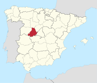
Ávila is a province of central-western Spain, in the southern part of the autonomous community of Castile and León. It is bordered on the south by the provinces of Toledo and Cáceres, on the west by Salamanca, on the north by Valladolid, and on the east by Segovia and Madrid. Ávila has a population of 158,265 (2018) and is ranked 47th out of 50 of Spanish provinces in population. Its capital is Ávila.
Samantha Bree (Jackson) Runnion was a five-year-old girl abducted from outside her home in Stanton, California, and murdered.

Ávila is a Spanish fortified city located in the autonomous community of Castile and León, and is the capital of the Province of Ávila.

Olvera Street is a historic district in downtown Los Angeles, and a part of El Pueblo de Los Angeles Historic Monument. Los Angeles was officially founded in 1781, Olvera Street obtained its current name in 1877. Many of the Plaza District's Historic Buildings are on Olvera Street, as well as some of the oldest Los Angeles monuments including the Avila Adobe built in 1818, Pelanconi House built in 1857, and the Sepulveda House built in 1887. The tree-shaded, pedestrian mall marketplace with craft shops, restaurants and roving troubadours is a popular tourist destination. The street has been described as a "Top Five" in the "Great Streets of America" journal.

John of Ávila was a Spanish priest, preacher, scholastic author, and religious mystic, who has been declared a saint and Doctor of the Church by the Catholic Church. He is called the "Apostle of Andalusia", for his extensive ministry in that region.

The Avila Adobe, built in 1818 by Francisco Avila, is the oldest standing residence in Los Angeles, California. It is located in the paseo of historical Olvera Street, a part of Los Angeles Plaza Historic District, a California State Historic Park. The building itself is registered as California Historical Landmark #145, while the entire historic district is both listed on the National Register of Historic Places and as a Los Angeles Historic-Cultural Monument.
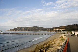
Avila Beach is an unincorporated community in San Luis Obispo County, California, United States, located on San Luis Obispo Bay about 160 miles (257 km) northwest of Los Angeles, and about 200 miles (320 km) south of San Francisco. For statistical purposes, the United States Census Bureau has defined Avila Beach as a census-designated place (CDP). The census definition of the area may not precisely correspond to local understanding of the area with the same name. The population was 1,627 at the 2010 census.

Saint Teresa of Avila Church is a Roman Catholic church in Bodega, California. The white, wooden church with a steeple sits on a hilltop overlooking Bodega Highway.
Rancho San Pascual also known as Rancho el Rincón de San Pascual was a 14,403-acre (58.29 km2) Mexican land grant in present-day Los Angeles County, California given to Juan Marine in 1834 by José Figueroa. Rancho San Pascual land now includes the cities of Pasadena, South Pasadena, and portions of San Marino, and the unincorporated communities of Altadena and San Pasqual.

Flores de Ávila is a municipality located in the province of Ávila, Castile and León, Spain, about 164km from Madrid. According to the 2005 census (INE), the municipality has a population of 395 inhabitants.

Eric Humberto Avila is an American soccer player who plays for Birmingham Legion in the USL Championship.

The El Pueblo de Los Ángeles Historical Monument, also known as Los Angeles Plaza Historic District and formerly known as El Pueblo de Los Ángeles State Historic Park, is a historic district taking in the oldest section of Los Angeles, known for many years as El Pueblo de Nuestra Señora la Reina de los Ángeles del Río de Porciúncula. The district, centered on the old plaza, was the city's center under Spanish (1781–1821), Mexican (1821–1847), and United States rule through most of the 19th century. The 44-acre park area was designated a state historic monument in 1953 and listed on the National Register of Historic Places in 1972.
Cornelio Ávila was the founder of a large and prominent southern California family.

Buhach is an unincorporated community in Merced County, California. It is located 2 miles (3.2 km) east-southeast of Atwater, at an elevation of 157 feet.
Rancho Las Cienegas was a 4,439-acre (17.96 km2) Mexican land grant in present-day Los Angeles County, California given in 1823 to Francisco Avila by Governor Luis Antonio Argüello. "La Cienega" is derived from the Spanish word cienaga, which means swamp or marshland and refers to the natural springs and wetlands in the area between the Baldwin Hills range and Baldwin Hills district, and Beverly Hills. The rancho was north of Rancho La Cienega o Paso de la Tijera and east of present-day La Cienega Boulevard between Wilshire Boulevard and Jefferson Boulevard. The Los Angeles River would periodically change course historically, and flowed through the rancho's lowlands to Ballona Creek and the Santa Monica Bay until 1825, when it returned to the flowing through Rancho San Pedro to San Pedro Bay.
Rancho Tajauta was a 3,560-acre (14.4 km2) Mexican land grant in present-day Los Angeles County, California given in 1843 by Governor Manuel Micheltorena to Anastasio Avila. The grant was named for the Gabrielino/Tongva place name of Tajáuta. The grant encompassed present-day Willowbrook and Watts.
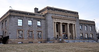
Ávila, sometimes Avila, may refer to:
Rancho Niguel was a 13,316-acre (53.89 km2) Mexican land grant in the San Joaquin Hills, within present-day Orange County, California.
John Buttencourt Avila (March 19, 1865 – December 25, 1937) was a California farmer who has been called the father of the sweet potato industry. He was a Portuguese American who came to California as a young man, and settled in Merced County.
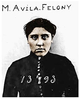
Modesta Avila was a protester in Orange County, California, who became the county's first convicted felon and first state prisoner. Avila had only received a minor warning in 1889 for placing an obstruction on the tracks to protest against the Santa Fe Railroad being built through her property without adequate compensation, but she continued to taunt the authorities, and was eventually arrested four months later.