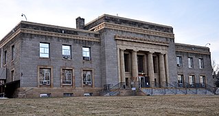
Lassen County is a county in the northeastern portion of the U.S. state of California. As of the 2010 census, the population was 34,895. The county seat and only incorporated city is Susanville.

Plumas County is a county in the Sierra Nevada of California, United States. As of the 2010 census, the population was 20,007. The county seat is Quincy, and the only incorporated city is Portola. The largest community in the county is East Quincy. The county was named for the Spanish Río de las Plumas, which flows through the county.
Hot Springs may refer to:

The Humboldt–Toiyabe National Forest (HTNF) is the principal U.S. National Forest in the U.S. state of Nevada, and has a smaller portion in Eastern California. With an area of 6,289,821 acres (25,454.00 km2), it is the largest National Forest of the United States outside Alaska.

Lassen Volcanic National Park is an American national park in northeastern California. The dominant feature of the park is Lassen Peak, the largest plug dome volcano in the world and the southernmost volcano in the Cascade Range. Lassen Volcanic National Park started as two separate national monuments designated by President Theodore Roosevelt in 1907: Cinder Cone National Monument and Lassen Peak National Monument.

The geology of the Lassen volcanic area presents a record of sedimentation and volcanic activity in the area in and around Lassen Volcanic National Park in Northern California, U.S. The park is located in the southernmost part of the Cascade Mountain Range in the Pacific Northwest region of the United States. Pacific Oceanic tectonic plates have plunged below the North American Plate in this part of North America for hundreds of millions of years. Heat from these subducting plates has fed scores of volcanoes in California, Oregon, Washington and British Columbia over at least the past 30 million years and is also responsible for activities in the Lassen volcanic area.

Lassen Peak, commonly referred to as Mount Lassen, is the southernmost active volcano in the Cascade Range of the Western United States. Located in the Shasta Cascade region of Northern California, it is part of the Cascade Volcanic Arc, which stretches from southwestern British Columbia to northern California. Lassen Peak reaches an elevation of 10,457 feet (3,187 m), standing above the northern Sacramento Valley. It supports many flora and fauna among its diverse habitats, which are subject to frequent snowfall and reach high elevations.

The geothermal areas in Lassen Volcanic National Park include several groups of hot springs and fumaroles, as remnants of former volcanic activity, exist in Lassen Volcanic National Park. Most of these lie in or are closely adjacent to Mount Tehama's caldera. Bumpass Hell is the most spectacular of these, but others of importance are Sulphur Works, Little Hot Springs Valley, Boiling Springs Lake and Devil's Kitchen. In each thermal area, the highest temperature of water generally is close to the boiling temperature at the altitude of the particular spring or fumarole — 198 °F (92 °C) at Bumpass Hell and 191 °F (88 °C) on the northwest flanks of Lassen Peak. Temperatures as high as 230 °F (110 °C) have been recorded in the park.

Cinder Cone is a cinder cone volcano in Lassen Volcanic National Park within the United States. It is located about 10 miles (16 km) northeast of Lassen Peak and provides an excellent view of Brokeoff Mountain, Lassen Peak, and Chaos Crags.

The Shasta Cascade region of California is located in the northeastern and north-central sections of the state bordering Oregon and Nevada, including far northern parts of the Central Valley and the Sierra Nevada mountain range.

Mount Tehama is an eroded andesitic stratovolcano in the Cascade Volcanic Arc and the Cascade Range in Northern California. Part of the Lassen volcanic area, its highest remaining remnant, Brokeoff Mountain, is itself the second highest peak in Lassen Volcanic National Park and connects to the park's highest point, Lassen Peak. Located on the border of Tehama County and Shasta County, Brokeoff's peak is the highest point in the former. The hikers that summit this mountain each year are treated to "exceptional" views of Lassen Peak, the Central Valley of California, and many of the park's other features. On clear days, Mount Shasta can also be seen in the distance.
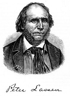
Peter Lassen was a Danish-American rancher and prospector. He was an early pioneer in California for whom Lassen County, Lassen Peak, and Lassen Volcanic National Park are named.

Lassen National Forest is a United States national forest of 1,700 square miles (4,300 km2) in northeastern California. It is named after pioneer Peter Lassen, who mined, ranched and promoted the area to emigrant parties in the 1850s.
Mill Creek is a large stream in northern California. It is an eastside tributary of the Sacramento River, draining an area of 134 square miles (350 km2) and flowing for 56.5 miles (90.9 km). The creek begins in Shasta County, California, but almost immediately flows into Tehama County, California. The creek's source is a thermal spring at an elevation of 8,200 feet (2,500 m) in Lassen Volcanic National Park. At first, the creek flows roughly south while meandering to the east and west, but the lower two-thirds of the creek flow roughly southwest until it reaches the Sacramento River at an elevation of only 200 feet (61 m), just north of Los Molinos, California.

Chilcoot is an unincorporated community in Plumas County, California. It lies at an elevation of 5,013 feet (1,528 m). Chilcoot is located 17 miles (27.4 km) east of Portola.
Hot Springs, California may refer to:
Tiptons Springs is a former settlement in Lassen County, California. It was located in the Secret Valley near the site of the present-day Karlo.
Sheep Springs is a former settlement in Lassen County, California. It was located 4.5 miles (7.2 km) northeast of Tiptons Springs.
Secret Springs is a former settlement in Lassen County, California. It was located at the south end of Secret Valley 4 miles (6.4 km) east of Tiptons Springs.
Sellicks Springs is a former settlement in Lassen County, California. It was located at the north end of Secret Valley 1.5 miles (2.4 km) northwest of Karlo.


