Lassen Volcanic National Park is an American national park in northeastern California. The dominant feature of the park is Lassen Peak, the largest plug dome volcano in the world and the southernmost volcano in the Cascade Range. Lassen Volcanic National Park started as two separate national monuments designated by President Theodore Roosevelt in 1907: Cinder Cone National Monument and Lassen Peak National Monument.
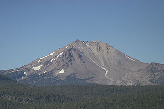
Lassen Peak, commonly referred to as Mount Lassen, is the southernmost active volcano in the Cascade Range of the Western United States. Located in the Shasta Cascade region of Northern California, it is part of the Cascade Volcanic Arc, which stretches from southwestern British Columbia to northern California. Lassen Peak reaches an elevation of 10,457 feet (3,187 m), standing above the northern Sacramento Valley. It supports many flora and fauna among its diverse habitats, which are subject to frequent snowfall and reach high elevations.

The Shasta Cascade region of California is located in the northeastern and north-central sections of the state bordering Oregon and Nevada, including far northern parts of the Central Valley and the Sierra Nevada mountain range.

Brokeoff Volcano is an eroded andesitic stratovolcano in the Cascade Volcanic Arc and the Cascade Range in Northern California. Part of the Lassen volcanic area, its highest remaining remnant, Brokeoff Mountain, is itself the second highest peak in Lassen Volcanic National Park and connects to the park's highest point, Lassen Peak. Located on the border of Tehama County and Shasta County, Brokeoff's peak is the highest point in the former. The hikers that summit this mountain each year are treated to "exceptional" views of Lassen Peak, the Central Valley of California, and many of the park's other features. On clear days, Mount Shasta can also be seen in the distance.
Leonard is both a masculine given name and a surname.
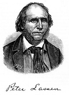
Peter Lassen was a Danish-American rancher and prospector. He was an early pioneer in California for whom Lassen County and Lassen Volcanic National Park are named.

Lassen National Forest is a United States national forest of 1,700 square miles (4,300 km2) in northeastern California. It is named after pioneer Peter Lassen, who mined, ranched and promoted the area to emigrant parties in the 1850s.

The Thousand Lakes Wilderness is located within the southern portion of the Cascade Range in northeastern California. The 16,335-acre (66 km2) wilderness was established in 1964 with the passage of the Wilderness Act and is administered by Lassen National Forest. The area lies within Shasta County, midway between the town of Burney and Lassen Volcanic National Park.

Leavitt is an unincorporated community in Lassen County, California, United States. It is located alongside the Southern Pacific Railroad 7 miles (11 km) east of Susanville, and 7 miles west of Litchfield, at an elevation of 4,104 feet (1,251 m).

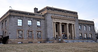
This is a list of the National Register of Historic Places listings in Lassen County, California.

Crest is an unincorporated community in Lassen County, California. It is located on the Southern Pacific Railroad 12 miles (19 km) north-northwest of Karlo, at an elevation of 5469 feet.
Edgemont is a former settlement in Lassen County, California. It was located 5.5 miles (8.9 km) south-southwest of Litchfield, at an elevation of 4032 feet.
Hot Springs is an unincorporated community in Lassen County, California. It lies at an elevation of 4167 feet.
Leonard, California may refer to:
Plumas is an unincorporated community in Lassen County, California. It is located on the Western Pacific Railroad 2.25 miles (3.6 km) southeast of Beckwourth Pass, at an elevation of 4941 feet.
Pumpkin Center is an unincorporated community in Lassen County, California. It is located 2.25 miles (3.6 km) east-southeast of Bieber, at an elevation of 4134 feet.
The Banner Lassen Medical Center is a 25 bed community hospital in Susanville, California, United States.

Brian Dahle is an American politician currently serving in the California State Assembly. He is a Republican representing the 1st district, encompassing the Shasta Cascade region and the northern Sierra Nevada. Prior to being elected to the state Assembly, he was a Lassen County supervisor for 16 years. He was first elected to the Assembly in 2012, and re-elected in 2014 and 2016.
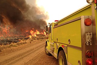
The Rush Fire was the largest wildfire of the 2012 California wildfire season. The fire, which started in Lassen County, California, eventually spread into Washoe County, Nevada. The fire consumed a total of 315,577 acres of sagebrush, of which 271,991 acres were in California. At the time, the burn area in California made the Rush Fire the second-largest wildfire in California since 1932. In December 2017, the Thomas Fire surpassed the Rush Fire to become the second-largest wildfire in modern California history, in terms of the area burned in California. In mid-August 2018, the Ranch Fire in the Mendocino Complex Fire surpassed the total acreage of the Rush Fire in both California and Nevada.