You can help expand this article with text translated from the corresponding article in Vietnamese. (October 2023)Click [show] for important translation instructions.
|
Ba Đồn | |
|---|---|
| Ba Đồn Town Thị xã Ba Đồn | |
 | |
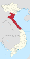
 Interactive map outlining Ba Đồn | |
 Ba Đồn Location within Vietnam  Ba Đồn Location within Southeast Asia 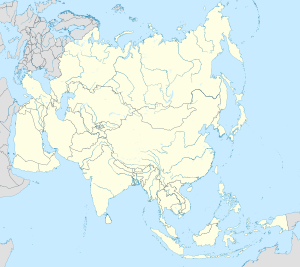 Ba Đồn Location within Asia | |
| Coordinates: 17°45′17″N106°25′23″E / 17.75472°N 106.42306°E | |
| Country | |
| Province | Quảng Bình |
| Area | |
• Total | 63 sq mi (162 km2) |
| Population (2019) | |
• Total | 134,000 |
| Time zone | UTC+7 (Indochina Time) |
Ba Đồn is a town (thị xã) in Quảng Bình Province, Vietnam. The town is equal to a huyện and is located on National Route 1, about 40 km north of the provincial capital, Đồng Hới. The township is the commercial and service centre serving surrounding rural areas. Ba Đồn was incorporated into a 3rd municipality (town or thị xã ) including some neighboring communes of Quảng Trạch District on December 20, 2013. [1]
Contents
Ba Đồn has an area of 163.1828 km2 and its population in 2013 was 115,196. In 2012, Ba Đồn was recognised as a class IV municipality. [2]