The Red River, also known as the Hong River and Sông Cái in Vietnamese, and the Yuan River in Chinese, is a 1,149-kilometer (714 mi)-long river that flows from Yunnan in Southwest China through northern Vietnam to the Gulf of Tonkin. According to C. Michael Hogan, the associated Red River Fault was instrumental in forming the entire South China Sea at least as early as 37 million years before present. The name red and southern position in China are associated in traditional cardinal directions. The river is relatively shallow, and carries a lot of reddish silt along its way, appearing red brown in colour.
Trà Vinh is a province in the Mekong Delta region of Southern Vietnam. The capital is Trà Vinh City.

Phú Thọ is a province in northern Vietnam. Its capital is Việt Trì, which is 80 kilometres (50 mi) from Hanoi and 50 kilometres (31 mi) from Nội Bài International Airport. The province covers an area of 3,534.56 km2 (1,364.70 sq mi) and, as of 2023, it had a population of 1,530,800.

Phú Yên is a central coastal province in the South Central Coast region, in Central Vietnam. It borders Bình Định to the north, Khánh Hòa to the south, Gia Lai to the northwest, Đắk Lắk to the southwest and the East Sea to the east.

Lệ Thủy is a district of Quảng Bình province in the North Central Coast of Vietnam. The district borders Quảng Ninh district on the north, Vĩnh Linh district on the south, Laos on the west. Lệ Thủy central is 40 km south of the provincial capital Đồng Hới. The district government seat is Kiến Giang Township. The district area is 1420.52 km2, population: 140,804 (1998). Lệ Thủy district is home to Võ Nguyên Giáp and the family of Ngô Đình Diệm. Economy bases on agriculture, mainly rice culture. Mỹ Trạch massacre by French army happened here on 29 November 1947.
Cầu Giấy is an urban district of Hanoi, the capital city of Vietnam. It is located within the Nhuệ and Tô Lịch River, situating roughly to the south-west of West Lake. With the sixth-highest population density among Hanoi's districts, Cầu Giấy hosts many administrative and corporate headquarters within the Trung Hoà–Nhân Chính urban area and is the central education hub of Hanoi.

Ba Vì is a district of Hanoi, Vietnam. Ba Vì district was established on July 26, 1968.

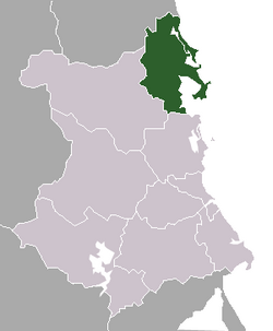
Hạ Hòa is a rural district of Phú Thọ province in the Northeast region of Vietnam. As of 2003, the district had a population of 108,556. The district covers an area of 340 km². The district capital lies at Hạ Hòa.
Thanh Ba is a rural district (huyện) of Phú Thọ province in the Northeast region of Vietnam. As of 2003 the district had a population of 109,806. The district covers an area of 194 km2. The district capital lies at Thanh Ba.

Thanh Thủy is a rural district of Phú Thọ province in the Northeast region of Vietnam. As of 2003, the district had a population of 76,330. The district covers an area of 124 km². The district capital lies at Thanh Thủy.

Đông Hòa is a district-level town of Phú Yên province in the South Central Coast region of Vietnam. Đông Hòa is a new town. However it is now dramatically developing with a lot of foreign investments such as Hòa Hiệp and Hoa Thám Industrial zones. Notable sights in the district include Bia Mountain, Han Dam, and Vũng Rô Harbor.

Đông Triều is a district-level town of Quảng Ninh Province in the north-eastern region of Vietnam. As of 2015 the district had a population of 173,141. The district covers an area of 397.2155 km². The town capital lies at Đông Triều ward.

Xuân Trường is a rural district of Nam Định province in the Red River Delta region of Vietnam. As of 2003 the district had a population of 179,765. The district covers an area of 113 km2. The district capital lies at Xuân Trường town.

Đồng Hỷ is a rural district of Thái Nguyên province in the Northeast region of Vietnam. As of April 1, 2019, the district had a population of 92.421. The district covers an area of 427,73 km2. The district capital lies at Hóa Thượng.

Vĩnh Tường is a rural district of Vĩnh Phúc province in the Red River Delta region of northern Vietnam. As of 2003, the district had a population of 189,970.

Cẩm Khê is a mountainous district in western Phú Thọ province, Vietnam. The district borders Hạ Hòa district to the north, Tam Nông district to the south, Yên Lập district to the west, and Thanh Ba district to the east. It covers an area of 234.2 square kilometres.

Bắc Từ Liêm is an urban district (quận) of Hanoi, the capital city of Vietnam. It was formed on 27 December 2013, when the rural Từ Liêm district was split into two urban districts: Bắc Từ Liêm and Nam Từ Liêm. The district currently has 13 wards, covering a total area of 45.32 square kilometers. As of 2019, there were 335,110 people residing in the district, the population density is 7400 inhabitants per square kilometer.
Xuân Phú may refer to several places in Vietnam, including: