Phú Mỹ

Last updated • 2 min readFrom Wikipedia, The Free Encyclopedia
Phú Mỹ
Thành phố Phú Mỹ
Phú Mỹ City
Dai Tong Lam Tu.jpg
Đại Tòng Lâm Temple
Nickname: 
Port city of the Southern
Phu My
Interactive map outlining Phú Mỹ
CountryVietnam
Region Southeast
Province Bà Rịa–Vũng Tàu
Provincial cityMarch 1, 2025
Capital Phú Mỹ
Area
128.90 sq mi (333.84 km2)
  Urban
94.03 sq mi (243.53 km2)
Population
 (2024)
287,055
  Density2,200/sq mi (860/km2)
   Urban
267,294
  Urban density2,800/sq mi (1,100/km2)
Time zone UTC+7 (ICT)
Postal code
787xx

Phú Mỹ is a provincial city (thành phố thuộc tỉnh) of Bà Rịa–Vũng Tàu province in southeast Vietnam. As of 2018 the city had a population of 175,872. [1] The city covers an area of 333.84 km².

Contents

Phú Mỹ was formerly Tân Thành District, a rural district of the province, with its district capital lying at Phú Mỹ township. In 2018, Tân Thành District was dissolved to form the new district-level town then city of Phú Mỹ.

The city seat lies at Phú Mỹ ward (former Phú Mỹ township) from which it takes its name. Phú Mỹ is a highly industrialized town with several industrial parks. It is the site of CS Wind's largest Vietnam wind tower factory. [2]

Phú Mỹ is home to deep water ports of Cái Mép–Thị Vải replacing Saigon Port when the latter relocated here. Phú Mỹ Power Plant Complex with a total capacity of 4,000 MW contributes nearly 35% of Vietnam's electricity.

History

Etymology

The town takes its name from the Phú Mỹ township, the capital of former Tân Thành District. The township was formally a commune and a village established in 1934 from the merger of Phú Thạnh and Mỹ Xuân, two villages founded in the area in the 19th century.

Before Vietnamese settlement

Archaeological evidence shows that modern humans had lived in Phú Mỹ in prehistory. In 2004, scientists conducted excavations in Gò Cây Me, an earthen hill in Tân Hòa Commune, and found relics of stony work tools, pottery and bones. The found relics were said to date back to the early metallic age circa 3500-3000 years before present. [3]

Between the 1st and 7th century, this area was controlled by the ancient Funan Kingdom. Later it was annexed by Chenla and administered as part of Chenla until the 17th century.

Vietnamese settlement

Due to conflicts and disturbance caused by the Trịnh-Nguyễn War, climate extremes, failing crops and factionism, Vietnamese people from the Central region migrated south, settled on Southeast and Southern region today. [4] [5] Many arrived in Mô Xoài (present-day Bà Rịa-Vũng Tàu) and established the earliest villages in the area.

In 1698, Lord Nguyễn Phúc Chu launched a military expedition to Southern region led by Nguyễn Hữu Cảnh.

Port of Phú Mỹ

The Port of Phú Mỹ (pronounced foo-me) serves as the main deep water cargo port for Ho Chi Minh City, as well as for the resort town of Vũng Tàu. [6] [7] The port is 65 km from Ho Chi Minh City and 45 km from Vũng Tàu city. [8] [9]

Administrative divisions

The city is divided administratively into ten commune-level subdivisions with the first seven are wards three latter are communes and the rest are :

Related Research Articles

Articles related to Vietnam and Vietnamese culture include:

<span class="mw-page-title-main">Bà Rịa–Vũng Tàu province</span> Province of Vietnam

Bà Rịa–Vũng Tàu is a province of Vietnam. It is located on the coast of the country's Southeast region. It also includes the Côn Đảo islands, located some distance off Vietnam's southeastern coast. From 1954 to 1975, under South Vietnam, the province was called Phước Tuy.

<span class="mw-page-title-main">Vũng Tàu</span> Provincial city in Bà Rịa–Vũng Tàu province, Vietnam

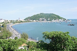
Vũng Tàu is the largest city of Bà Rịa–Vũng Tàu province in southern Vietnam. It is the province's economic, financial and cultural centre, and a popular tourist hub in southern Vietnam. The city area is 141.1 square kilometres, consists of 16 urban wards and one commune of Long Sơn Island. Vũng Tàu was the capital of the province until it was replaced by the much smaller Bà Rịa city on 2 May 2012. The city is also the crude oil extraction center of Vietnam.

<span class="mw-page-title-main">Bến Tre province</span> Province of Vietnam

Bến Tre is a province of Vietnam. It is one of the country's southern provinces, and is situated in the Mekong Delta. It is also famous for its coconuts and the Coconut Religion nationwide. Disconnected from the mainland, the province lies mainly on 2 river islands. It has land borders only with Vĩnh Long Province, which occupies the western tip of the southern river island.

<span class="mw-page-title-main">Tiền Giang province</span> Province of Vietnam

Tiền Giang is a province in the Mekong Delta region of southern Vietnam.

<span class="mw-page-title-main">Thủ Dầu Một</span> Provincial city in Bình Dương, Vietnam

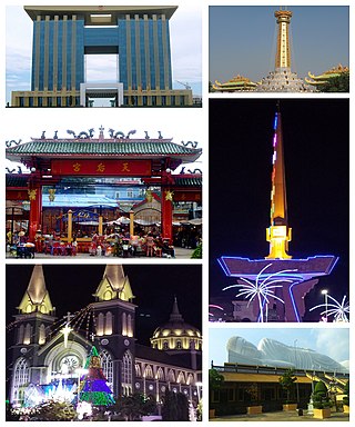
Thủ Dầu Một is the capital city of Bình Dương province, Vietnam, located at around 10°58′0″N106°39′0″E. The city has an area of 118.91 km², with a population of 336.705, and is located 20 km north of downtown Ho Chi Minh City, on the left bank of the Saigon River, upstream from the city.

<span class="mw-page-title-main">Bà Rịa</span> Provincial city in Bà Rịa–Vũng Tàu, Vietnam

Bà Rịa is a city in Bà Rịa–Vũng Tàu province in the Southeast region of Vietnam. Bà Rịa is adjacented to Vũng Tàu by Cỏ May river and connected by Cỏ May Bridge on National Route 51. This is the de jure seat of the province since most of the provincial administration agencies are located here. Since May 2012, Bà Rịa officially replacing Vũng Tàu to become the provincial capital of Bà Rịa–Vũng Tàu.

Tan Thanh may refer to several populated places in Vietnam:

<span class="mw-page-title-main">Đồng Hỷ district</span> District in Northeast, Vietnam

Đồng Hỷ is a rural district of Thái Nguyên province in the Northeast region of Vietnam. As of April 1, 2019, the district had a population of 92.421. The district covers an area of 427,73 km2. The district capital lies at Hóa Thượng.

<span class="mw-page-title-main">Ho Chi Minh City metropolitan area</span> Place in Vietnam

Ho Chi Minh City metropolitan area is a metropolitan area that was in June 2008 proposed by the Ministry of Construction of Vietnam to the Government of Vietnam for approval. According to this master plan, this metropolitan area will include provinces around Ho Chi Minh City in the Southeast region and 2 provinces in the Mekong Delta region.

Phú Mỹ is a district-level town of Bà Rịa–Vũng Tàu province, Vietnam.

Tân Phú may refer to several places in Vietnam, including:

Tân Hòa may refer to several places in Vietnam, including:

<span class="mw-page-title-main">Trường Sa district</span> District in South Central Coast, Vietnam

Trường Sa is an island district of Khánh Hòa province in the South Central Coast region of Vietnam. It was established on the basis of the Spratly Islands, which is also claimed wholly or in part by Brunei, China, Malaysia, the Philippines and Taiwan. According to the 2009 census, the district has a population of 195 people.

<span class="mw-page-title-main">Six Provinces of Southern Vietnam</span>

The Six Provinces of Southern Vietnam is a historical name for the region of Southern Vietnam, which is referred to in French as Basse-Cochinchine. The region was politically defined and established after the inauguration of the Nguyễn dynasty, and called by this name from 1832, when Emperor Minh Mạng introduced administrative reforms, to 1867, which culminated in the eight-year French campaign to conquer the Six Provinces.

Bàu Bàng is a rural district of Bình Dương province in the Southeast region of Vietnam. It was established on December 29, 2013, and has a population of over 82,000.

<span class="mw-page-title-main">Thứ phi Hoàng Phi Yến</span>

Imperial Concubine Phi Yến, born Lê Thị Răm, is a controversial local legend of the Côn Đảo archipelago, Bà Rịa–Vũng Tàu province. According to the legend she was the concubine of Lord Nguyễn Phúc Ánh and gave birth to a son known as Prince Cải, she advised Lord Ánh not to ask foreigners for help as that would make their victory less glorious and might cause issues in future, these comments caused Lord Ánh to be suspicious of her motives and to lock her up in a cave. Later when their toddler asked where his mother was he killed him. She grieved their son and later committed suicide as she was touched by a butcher during a vegetarian festival seeing it as "harming her honour as a concubine". This caused the villagers of Côn Đảo to hold a festival in her honour every year.

References

  1. "Nghị quyết số 492/NQ-UBTVQH14 của Ủy ban Thường vụ Quốc hội về việc thành lập thị xã Phú Mỹ và các phường thuộc thị xã Phú Mỹ, tỉnh Bà Rịa–Vũng Tàu". 14 October 2020.
  2. Meek, James (15 July 2021). "Who holds the welding rod?". London Review of Books. 43 (14). Retrieved 10 July 2021.
  3. Nguyễn, Mạnh Thắng; Trương, Đắc Chiến (2008-09-01). "Khai quật di chỉ Gò Cây Me" [Excavation of Gò Cây Me Site]. Bảo tàng lịch sử Việt Nam.
  4. "Vùng đất Nam Bộ dưới thời Chân Lạp trông như thế nào?" [How did Nam Bộ under Chenla rule look like?]. Dân Việt (in Vietnamese). 2019-09-09.
  5. Trần, Thị Phương Thảo (2013-01-07). "Xứ Mô Xoài - mảnh đất đầu tiên được khai phá trong tiến trình mở cõi về Nam Bộ" [Mô Xoài - the first exploited land in the process of Southward expansion]. Bảo tàng Lịch sử Quốc gia (in Vietnamese).
  6. "Phu My Port - port and navigational information". Vietnam Ports Association. Retrieved 3 January 2019.
  7. Guide to port entry. London: IHS Port Guides. 2 January 2018.
  8. "Day tours from Phu My Port". www.itourvn.com. "I tour Vietnam" Blog. Retrieved 3 January 2019.
  9. "About Phu My Port". www.bariaserece.com/. Retrieved 3 January 2019.


10°34′50″N107°05′06″E / 10.58056°N 107.08500°E / 10.58056; 107.08500