
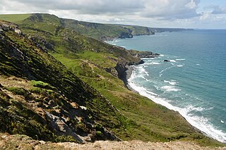
Aire Point to Carrick Du SSSI is a Site of Special Scientific Interest on the Penwith Peninsula, Cornwall, England. It is 5.98 square kilometres in extent, stretching from grid reference SW360279 to grid reference SW513410. The site is designated both for its biological and its geological interest.

The Whin Sill or Great Whin Sill is a tabular layer of the igneous rock dolerite in County Durham, Northumberland and Cumbria in the northeast of England. It lies partly in the North Pennines Area of Outstanding Natural Beauty and partly in Northumberland National Park and stretches from Teesdale northwards towards Berwick.

Lambert's Castle is an Iron Age hillfort in the county of Dorset in southwest England. Since 1981 it has been designated as a Site of Special Scientific Interest (SSSI) on account of its geology, archaeology and ecology. The hillfort is designated a scheduled monument together with a bowl barrow, the sites of a post-medieval fair and a telegraph station.
Boscastle to Widemouth is a coastal Site of Special Scientific Interest (SSSI) in Cornwall, England, noted for its biological and geological characteristics. The Dizzard dwarf oak woodland is unique and of international importance for its lichen communities, with 131 species recorded.

Steeple Point to Marsland Mouth is a coastal Site of Special Scientific Interest (SSSI) in Cornwall, England, UK, noted for its biological characteristics.

Aber Taf is a large Site of Special Scientific Interest (SSSI) in Carmarthenshire, Wales, and forms part of the Carmarthen Bay and Estuaries Special Area of Conservation.

Allolee to Walltown is the name given to a Site of Special Scientific Interest (SSSI) in Northumberland, England. The site, which follows the path of a section of Hadrian's Wall, is notable for an unusually wide range of grassland types growing on thin soil above the Whin Sill, a rock formation peculiar to the Northern Pennines.
Alnmouth Saltmarsh and Dunes is a Site of Special Scientific Interest (SSSI) in Northumberland, England. It is the largest saltflat on the north-east coast, located on the south bank of the River Aln estuary, and notable for the varied plant community found on the interface between the saltflats and the dunes. It overlaps with and forms part of the much larger Northumberland Shore SSSI.
Arcot Hall Grasslands and Ponds is the name given to a Site of Special Scientific Interest (SSSI) near Cramlington in Northumberland, England, notable as the largest lowland species-rich grassland in North East England. The site is composed of grassland, heath, ponds, and associated damp habitats now rare in Northumberland.
Aules Hill Meadows is the name given to a Site of Special Scientific Interest (SSSI) in Northumberland, England. The site, listed since 1992, is a set of four traditionally managed northern hay meadows, now rare in Northumberland.
Barelees Pond is the name given to a Site of Special Scientific Interest (SSSI) in north Northumberland, England. The site is a kettle hole, a deep pond formed in the void remaining after a submerged glacial calf block melted. Barelees Pond is illustrative of vegetative habitat evolution as peat sediment gradually fills the pond.
Barrow Burn Meadows is a Site of Special Scientific Interest (SSSI) in north Northumberland, England. The site is a species-rich hay meadow of a sort now rare in Northumberland.
Bavington Crags is a Site of Special Scientific Interest (SSSI) in north Northumberland, England. The site is an outcropping of the Whin Sill which gives rise to distinctive flora particular to the thin soil conditions on this bedrock.
Budle Bay is a 1 mile (1.6 km) wide bay on the North Sea in Northumberland, England, between Bamburgh to the southeast and Lindisfarne to the northwest.

Bewick and Beanley Moors is the name given to a Site of Special Scientific Interest (SSSI) in north Northumberland, in the north-east of England. The moors are asserted to be of national importance by Natural England for the extent, quality and diversity of upland types including heaths, fens, wet grassland, flushes, mires and blanket bogs, together creating an extensive mosaic habitat supporting an exceptional community of amphibians. The moors are important, too, for their relict juniper woodland and scrub.
Brada Hill is a small hill escarpment near the coast of north Northumberland in North East England, designated as a Site of Special Scientific Interest (SSSI). The 2.4 hectares site is an outcropping of a local stone group, the Whin Sill, on which grows a range of flora representative of the thin, drought-prone soil conditions and influenced by the underlying geology.
Burnfoot River Shingle and Wydon Nabb is the name given to a Site of Special Scientific Interest (SSSI) in Northumberland, North East England. Burnfoot River Shingle is a calaminarian grassland on the River South Tyne where the local flora is influenced by high levels of naturally occurring heavy metals. Wydon Nabb is an escarpment displaying the Haltwhistle Dyke, a magmatic intrusion of igneous dolerite set amidst sedimentary sandstone and shale.
Longhoughton Quarry is a Site of Special Scientific Interest (SSSI) in north Northumberland in North East England. The site is a now disused quarry which yielded whinstone, a hard dark rock associated in Northumberland with the Whin Sill.
Fallowlees Flush is the name given to a Site of Special Scientific Interest (SSSI) in mid-Northumberland, England. The steeply sloping site has calcium-rich springs supporting vegetation rare in the county.

Hatherton Flush is a Site of Special Scientific Interest (SSSI) by the River Weaver in Hatherton, near Wybunbury, Cheshire, England. It is protected for its variety of wetland plants. Species found at the site include the locally rare plants marsh helleborine, marsh lousewort and tubular water dropwort. Hatherton Flush is the largest example of this kind of flush in the county. The site was assessed as being in an "unfavourable"/"recovering" condition in 2008.
