Bareq (Arabic : بارق; also transliterated as Bāriq), is one of the governorates of Asir in the north-west of the region, 120 km (75 mi) north of Abha. It occupies a distinct location midway between Tihama and Asir, 412 m (1,352 ft) above sea level. With an estimated population of 75,351, it is well off economically; the city has grown rapidly and has many government services and public utilities available. It is one of Asir's winter resorts because of its natural environment and mild winter weather. Bareq has valleys.
Bareq was founded in 220 AD. (citation?) Bareq is part of the territory which is historically known as the "yamen" as in ancient Arabs in Hijaz referred to the south from their perspective as "yamen" which is today's southern Saudi Arabia, which dates back to the second millennium BC and was inhabited by a tribe called Bariq belonging to the ancient tribe of Al-Azd that has many clans linked to it. [1] [2] [3] Known before the advent of Islam as Diyār Bāriq, it was traversed by the ancient trade route from South Arabia to Mecca and the Levant, known as the winter and summer journeys. [4] [5] It also used to hold the Suq Hubasha [6] in the first eight days of the month of Rajab (other sources say three days). [7] The market and convoys were protected by the Bareq country and this souq was the market for Azd. It was one of the greatest Arab souqs of all, and also the last of the pre-Islamic markets to be destroyed. [8] In the mid-seventh century AD, the Bareq tribe entered Islam and played a pivotal and a major role in the Muslim conquests, [9] [10] [11] [12] [13] [14] and many Bariqis settled in various countries after the Muslim conquest. [15] [16] [17]
At the rise of the First Saudi State in the 18th century, the villages of Bareq were governed by local clans in a fashion similar to that of Nejd, while the large tribal confederations maintained a high degree of autonomy. Bareq gave allegiance to First Saudi State in 1809 under the leadership of the Bareq chief Ahmed Ibn Zahir of the Humaydah clan. [18] [19] When the First Saudi State was destroyed by the Egyptians in 1818, the Bariqis continued to fight the Egyptian forces in their region tenaciously. With the withdrawal of the Egyptians in 1840. [20]
In 1872 the Turks took direct control of the region, making Bareq a sanjak of Turkish Yemen, remained in the Ottoman Empire for 42 years. [21] [22] In the 1880s, the Idrissi dynasty of Sabya became the predominant political force, ruling the region under the supervision of Turkish advisors. In the early twentieth century, in 1910, Muhammad ibn Ali al-Idrisi, a descendant of Ahmad Ibn Idris, began to establish political control of Bareq. After negotiations with Italy, which had interests nearby in Somalia, the Idrisi forces of Muhammad came into conflict with Ottoman forces in Ajama. The Idrisis were defeated in 1911 by Hashemite forces under Hussein ibn Ali, Sharif of Mecca, [23] then still loyal to the Ottomans, but the tide turned when Muhammad ibn Ali concluded a secret military alliance with Great Britain (by then at war with the Ottomans) in 1915, and Sharif Hussein later switched sides and joined the British against the Ottomans. [24]
Turkish troops were withdrawn following the outbreak of war in 1914, and Turkish rule in Bareq became even more tenuous. In April 1915, British agents, hoping to garner Bariqis support for the Allies, signed a treaty with the Idrisi emir guaranteeing the independence and security of Bareq upon the defeat of the Turks. Bariqi troops fought the Turks as allies of the British forces in January 1917;, in a subsequent agreement, the British government of India promised independence at the end of the war.
After the end of First World War, Muhammad ibn Ali became ruler of an internationally recognized sovereign state, until his death in 1920. The territories of the emirate reached from Bareq in the north to Hudaydah in the south. Muhammad's successors were however unable to resist the growing power of Abd Al-Aziz Ibn Saud, who began controlling South of Arabian Peninsula and its neighboring regions after Muhammad's death. Bareq accepted being part of Kingdom Saudi Arabia in 1924, [25] and from then on Bareq was controlled by the House of Sa'ud.
Bariq is at an elevation of 412 m (1,352 ft) above sea level, and approximately 90 km (56 mi) inland from the Red Sea. It's lies 120 km (75 mi) km north-west of Abha (Occupying a distinct location at the road junction at the middle between Tihama and Asir). The district of Bariq begins about 10 miles (16 km) north of "Muha'il", and covers an area of about 40 miles (64 km) from north to south and 57 miles (92 km) from east to west, and are bounded by Tanomah to the east, Majaridah to the north, Muhail to the south, and Qunfudhah to the west. [26] It is a fertile country and well watered and extensively cultivated, maize, millet, barley, and sesame being the principal crops. [27] [28]
The inhabitants of Bareq are largely made up of the Sunnis Saudi Arabians. There are also significant foreign populations, primarily from Asia, Turkey, and other Arab countries.
In Bareq & surrounding areas, a local dialect of Arabic is spoken, which is known as Bareqi Arabic (Arabic: لهجة بارقية, lahjat bariqia), spoken by some 60,000 people. It shares similarities with the Hejazi & Najdi dialects, as well as the Himyaritic language.
The region's crops, most of which are cultivated on small plains irrigated by the floods or on the silt of the stream beds. include wheat, coffee, indigo, ginger, vegetables, and sesame. It is one of the best agricultural districts in Saudi Arabia. The region also supports cattle, sheep, and goats. [29]
The first school in Bareq was established in 1952. Today Bareq is home to more than 100 public educational institutes.
Bareq has an arid tropical climate with an average annual temperature of 86.5 °F (30.3 °C). January typically sees daytime highs of 82 °F (28 °C) and lows of 64 °F (18 °C), while July has average daytime highs of 92 °F (33 °C) and lows of 69 °F (21 °C). With an average annual temperature of 66.8 °F (19.3 °C).
Climate data for Bareq, Saudi Arabia | |||||||||||||
---|---|---|---|---|---|---|---|---|---|---|---|---|---|
Month | Jan | Feb | Mar | Apr | May | Jun | Jul | Aug | Sep | Oct | Nov | Dec | Year |
Mean daily maximum °F (°C) | 82 (28) | 83 (28) | 84 (29) | 86 (30) | 86 (30) | 88 (31) | 92 (33) | 91 (33) | 90 (32) | 87 (31) | 86 (30) | 84 (29) | 87 (30) |
Mean daily minimum °F (°C) | 64 (18) | 66 (19) | 66 (19) | 67 (19) | 67 (19) | 68 (20) | 69 (21) | 69 (21) | 68 (20) | 67 (19) | 66 (19) | 65 (18) | 67 (19) |
Source: . [30] |
Bareq is known for its cuisine and traditional meals such as jalamah, khmer, haneeth, lahoh, murtabak, aerykh, asida, muqalqal, and mandi.
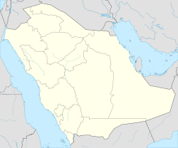
Asir, officially the Asir Province, is a province in the southwest of Saudi Arabia, which is named after the ʿAsīr tribe. It has an area of 76,693 square kilometres (29,611 sq mi), and an estimated population of 2,024,285. ʿAsīr is surrounded by Mecca Province to the north and west, Al-Bahah Province to the northwest, Riyadh Province to the northeast, Najran Province to the southeast, and Jazan Province and the Yemeni Muhafazah (Governorate) of Saada to the south.
The Azd, or Al-Azd, is an ancient Arabian tribe. The lands of Azd occupied an area west of Bisha and Al Bahah in what is today Saudi Arabia.
AITF also known as Aitf Al-Salim, is a village in the sub-governorate of Bariq in the province of Asir, Saudi Arabia. It is located at an elevation of 432 metres (1,417 ft) and has a population of about 500 to 1,000.
Al-Ghamdi is an Arabic family name denoting a member of the Ghamd tribe of Saudi Arabia.
The Banu Shahr is a tribe from the southern part of the Arabian Peninsula. It belongs to the ancient tribe al-Azd that has many clans linked to it. As far as ancestry goes, Banu Shahr, Bani Amr, Bal-Ahmar, Bal-Asmar, Bal-Qarn, Shumran, and some others all belong to "al-Azd".
The Idrisid Emirate of Asir was a state located in the Arabian Peninsula. The Emirate was in the geographical region of Asir and Jizan, in what is now southwestern Saudi Arabia, and extending to Hodeidah, northwest of Yemen.
The Ghamid is an Azd Arab tribe of the Hejaz Region. They are predominantly Sunni, and are considered one of the oldest tribes of the Arabian Peninsula. The Ghamid people are thought to be closely related to the neighboring tribe of Zahran.
Bariq is a tribe from Bareq in south-west Saudi Arabia. It belongs to the ancient Al-Azd tribe which has many clans linked to it. As far as ancestry goes, Aws, Khazraj, Ghassān and Banu Khuza'a, and others all belong to Al-Azd. They were one of the tribes of Arabia during Muhammad's era.
Humaydah ibn an-Nu'man al-Bariqi, was a companion of Muhammad. He was the leader of the tribe of Bariq and an extremely successful military general during the reign of Rashidun Caliph Umar. Humaydah also fought under Sa`d's command against the Sassanid army at the Battle of al-Qādisiyyah.
Jabal Atherb is a mountain in Bareq, Saudi Arabia. The mountain consist primarily of sedimentary rock of Jurassic, Cretaceous, and Tertiary origin.
Humaydah, is an Arab tribe, a subgroup of the Bariq tribe of the Qahtanite people. They were a powerful house which governed the city of Bareq until the Ibn Saud invasion and lived peacefully beside al-Ali.
Ajama also known as Suq-El-Ajama or Rabu' el-A'jama , Arabic: العجمة) is a village in the sub-governorate of Bariq in the province of Asir, Saudi Arabia. It is located at an elevation of 375 metres (1,230 ft) and has a population of about 1,000 to 2,000 naming comes from Al-Ajmeh - by opening the neglected eye, al-Jim and al-Mim - and al-Ajmeh, as the linguists originally put it, is al-Sakhr al-Salab, which is the well-known limestone.. It was the capital of The Humaydah tribe. Kinahan Cornwallis Said (1916), suq el-ajamah a large village of about 300 stone houses, former seat of a Turkish markaz and the most important market of the neighbourhood.
Munaydhir is a village in the sub-governorate of Bariq in the province of Asir, Saudi Arabia. It is located at an elevation of 382 metres (1,253 ft) and has a population of about 500 to 2,000.
Farah, Arabic: الفرعة) is a village in the sub-governorate of Bariq in the province of Asir, Saudi Arabia. It is located at an elevation of 469 metres (1,539 ft) and has a population of about 500 to 1,000. It is connected with the main road by a 6.2 Kilometer.
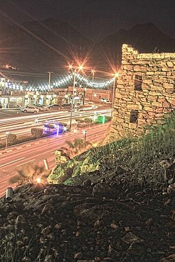
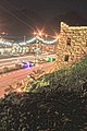
Qafeel, is a neighborhood in the sub-governorate of Bariq in the province of Asir, Saudi Arabia. It is located at an elevation of 390 metres (1,280 ft) and has a population of 5,000. It is one of the largest neighborhoods of Bareq.
Bariq was founded in 220 AD. It is part of the territory known historically as Yemen, which dates back to the second millennium BC. It was inhabited by immigrant tribes of southern Yemen called Bariq, who belong to the ancient tribe Al-Azd which has many clans linked to it.
Gdraymah is a town in the sub-governorate of Bariq in the province of Asir, Saudi Arabia. It is located at an elevation of 460 metres (1,510 ft) and has a population amounts to 5,000 (2010).
Bilad al-Musa is a village in the sub-governorate of Bariq in the province of Asir, Saudi Arabia. It is located at an elevation of 435 meters and had a population of 5,000 in 1970. It is connected with the main road by a 3 kilometer road. The headman is Ahmed Hiyazah Fayiz Hiyazah.
Al-Qarn also known as Qarn Mikhled, is a village in the sub-governorate of Bariq in the 'Asir Province, Saudi Arabia. It is located at an elevation of 370 metres (1,210 ft) and has a population of about 500 to 2,000. It is best known for being the birthplace of Uwais al-Qarni.
Muzayqiya, real name 'Amr was the leader of the Azd tribes and a king ruling parts of Yemen in the 2nd century CE. Muzayqiya succeeded his brother Imran in the leadership of the kingdom. During his time, the Ma'rib Dam collapsed which resulted in several Qahtanite tribes emigrating from Yemen.
{{cite book}}
: CS1 maint: location missing publisher (link){{cite book}}
: CS1 maint: location missing publisher (link)