
Sunny Hill Park is a park in Hendon, in the London Borough of Barnet, England. It is a large hilly park, 22 hectares, mainly grassed, which has extensive views to the north and the west. Together with the neighbouring Hendon Churchyard, it is a Site of Local Importance for Nature Conservation.

Arrandene Open Space and Featherstone Hill is a 25 hectare Site of Metropolitan Importance for Nature Conservation in Mill Hill in the London Borough of Barnet.

Hadley Green is a 10-hectare (25-acre) Site of Metropolitan Importance for Nature Conservation in Hadley in the London Borough of Barnet. The reserve straddles the Great North Road between Hadley Green Road and Fold Lane.

Coppetts Wood and Scrublands is a 14.5-hectare (36-acre) Site of Borough Importance for Nature Conservation, Grade I, between Muswell Hill and Friern Barnet in the London Borough of Barnet. It is part of the Coppetts Wood and Glebelands Local Nature Reserve.

Glebelands is Site of Borough Importance for Nature Conservation, Grade I, in Colney Hatch in the London Borough of Barnet. It is also part of the Coppett's Wood and Glebelands Local Nature Reserve.
Rowley Lodge Field is a Site of Borough Importance for Nature Conservation, Grade II, in Arkley in the London Borough of Barnet.

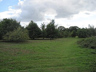
Arkley Lane and Pastures is a 50-hectare (120-acre) Site of Borough Importance for Nature Conservation, Grade II, in Arkley in the London Borough of Barnet. Arkley Lane, off Barnet Road, is an old drovers' road. Located on the Barnet Plateau, it is now a quiet country lane with a traditional bank and ditch. The thick hedges are composed of beech and hornbeam, ash, field maple and magnificent old pedunculate oaks.

Belmont Open Space is a one hectare public park and Site of Local Importance for Nature Conservation in Cockfosters in the London Borough of Barnet.
Totteridge Green is a five hectare Site of Borough Importance for Nature Conservation, Grade II, in Totteridge in the London Borough of Barnet. It is also registered common land.

Edgware Way Grassland or Edgware Way Rough is a 6.7-hectare (17-acre) Site of Metropolitan Importance for Nature Conservation in Edgware in the London Borough of Barnet. It is traversed by Edgwarebury Brook and contains traces of a planned railway viaduct and embankment. This was part of a planned extension of the Northern line from Edgware to Bushey, which was cancelled when the introduction of the Green Belt after the Second World War led to the cancellation of the developments which the railway was to serve. Part of the site is the Environment Agency's Edgwarebury Park Flood Storage Area.

Totteridge Common is a 3.7 hectare Site of Borough Importance for Nature Conservation, Grade II, in Totteridge in the London Borough of Barnet. The nature reserve is the southern verge of the road Totteridge Common, between Totteridge Park and Oak Lodge. It is registered common land owned by the Totteridge Manor Association and comprised the lands of the former Manor of Totteridge which were transferred to the association in 1954.

Drivers Hill is a ten hectare Site of Borough Importance for Nature Conservation, Grade II, in Mill Hill in the London Borough of Barnet. It is owned by the Jehovah's Witnesses, who built their national headquarters, Watch Tower House, on the site in 1955. The house is a major printing works where 120 million Jehovah's Witnesses periodicals were printed in 2002.

Friary Park is a nine hectare formal Edwardian park in Friern Barnet in the London Borough of Barnet.

Copthall South Fields is a six hectare Site of Local Importance for Nature Conservation, next to Fiveways Corner on the A1, in Mill Hill in the London Borough of Barnet.

Princes Park is a small public park and Site of Local Importance for Nature Conservation in Temple Fortune in the London Borough of Barnet.

Clarefield Park is a small park and Site of Local Importance for Nature Conservation in Brent Cross in the London Borough of Barnet.
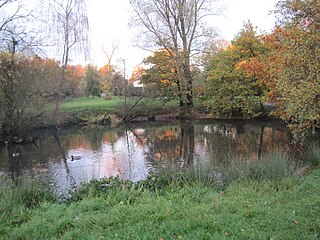
Clitterhouse Recreation Ground or Clitterhouse Playing Fields is a park and Site of Local Importance for Nature Conservation in Brent Cross in the London Borough of Barnet. It is a large area of mown grass with a children's playground, bordered by thick hedges. Clitterhouse Stream, a tributary of the River Brent, runs along its eastern border.

Clay Lane is a one kilometre long public footpath and bridle way in Edgware in the London Borough of Barnet. It is a Site of Local Importance for Nature Conservation.

Cranebank is a Local Nature Reserve on the east bank of the River Crane in Hatton in the London Borough of Hounslow. It is owned and managed by Hounslow Council. It is also part of The Crane Corridor Site of Metropolitan Importance for Nature Conservation.
