
Finchley is a large district of north London, England, in the London Borough of Barnet. Finchley is on high ground, 11 km (6.8 mi) north of Charing Cross.

The London Borough of Barnet is a suburban London borough in North West London. The borough was formed in 1965 from parts of the ceremonial counties of Middlesex and Hertfordshire. It forms part of Outer London and is the second largest London borough by population with 389,344 inhabitants, also making it the 17th largest district in England. The borough covers an area of 86.74 square kilometres (33 sq mi), the fourth highest of the 32 London boroughs, and has a population density of 45.8 people per hectare, which ranks it 25th.

East Finchley is an area in North London, immediately north of Hampstead Heath. Like neighbouring Muswell Hill, it straddles the London Boroughs of Barnet and Haringey, with most of East Finchley falling into the London Borough of Barnet. It has the greenest high road in London.

Temple Fortune is a place in the London Borough of Barnet to the north of Golders Green. It is principally a shopping district used by residents of the Hampstead Garden Suburb. Between here and Golders Green, at Hoop Lane are two cemeteries – Golders Green Jewish Cemetery and Golders Green Crematorium. Religious buildings include the Catholic Church of St Edward the Confessor, St. Mary & Archangel Michael Coptic Orthodox Church, and North Western Reform Synagogue.

Dollis Brook runs through the London Borough of Barnet in north London. It is a tributary of the River Brent, which is itself a tributary of the River Thames. The Dollis Valley Greenwalk follows almost all of Dollis Brook, apart from a short section at the beginning which passes through private land, and the London Loop follows it as far as Barnet Lane. The name Dollis is probably derived from the Middle English word 'dole', meaning the shares of land in the common field.

Avenue House is a large Victorian mansion situated on East End Road in Finchley in the London Borough of Barnet.

Finchley, which is now in north London, was a local government district in Middlesex, England, from 1878 to 1965. Finchley Local Board first met in 1878. It became Finchley Urban District Council in 1895 and the Municipal Borough of Finchley in 1933. In 1965 Middlesex was abolished and Finchley became part of the London Borough of Barnet.
The London Borough of Barnet, located on the northern periphery of London and having much of the area within its boundaries in the Metropolitan Green Belt, has many parks and open spaces. In addition there are large areas taken over by cemeteries and golf courses, and part of Hampstead Heath.

Victoria Park is in Church End in Finchley in the London Borough of Barnet. It covers seven hectares. It is on the east side of Ballards Lane and fairly close to Finchley Central and West Finchley tube stations.

The Dollis Valley Greenwalk is a footpath route in the London Borough of Barnet in London, England, between Moat Mount Nature Reserve in Mill Hill and Hampstead Heath. The route is designed to act as a link between the Capital Ring and the London Loop, and between the many green spaces and wildlife corridors along the way. It is approximately 10 miles (16 km) long. It mainly follows the Dollis Brook and is one of the many parks and open spaces in Barnet.

Barnet Gate Wood is a public open space in Barnet Gate, Barnet, London. It is owned and managed by the London Borough of Barnet, and is part of the Watling Chase Community Forest.

King George's Fields is a 28-hectare (69-acre) Site of Borough Importance for Nature Conservation, Grade II, in Monken Hadley in the London Borough of Barnet.

Coppetts Wood and Scrublands is a 14.5-hectare (36-acre) Site of Borough Importance for Nature Conservation, Grade I, between Muswell Hill and Friern Barnet in the London Borough of Barnet. It is part of the Coppetts Wood and Glebelands Local Nature Reserve.

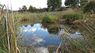
Lakeside Nature Reserve is a small Site of Local Importance for Nature Conservation in Church End, Finchley in the London Borough of Barnet. Its main feature is a pond which was constructed in the late 1890s by Peter Edmund Kay as a reservoir to store rainwater for commercial greenhouses in the Claigmar Vineyard, a large market garden in the late nineteenth and early twentieth centuries. The pond has a fountain and plants fringing the shore include water mint, gypsywort and purple-loosestrife. Waterfowl nest on a small island and there are dragonflies in summer.

Mutton Brook is a stream which runs between East Finchley and Hendon in the London Borough of Barnet. It is a tributary of the River Brent, which is itself a tributary of the River Thames.

Princes Park is a small public park and Site of Local Importance for Nature Conservation in Temple Fortune in the London Borough of Barnet.
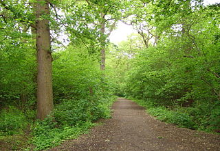
Big Wood and Little Wood are two patches of woodland in Hampstead Garden Suburb in the London Borough of Barnet. They are a Site of Borough Importance for Nature Conservation, Grade 1, and a Local Nature Reserve. Big Wood is 7.3 hectares and Little Wood is 1.2 hectares.

Bethune Park or Bethune Recreation Ground is a public park in Friern Barnet in the London Borough of Barnet. Most of it is mown grass, and it also has a large nature reserve area, a children's playground, a basketball court and a tennis court.
Long Lane Pasture is a 1.1-hectare (2.7-acre) nature reserve in Finchley in the London Borough of Barnet. It is owned by Barnet Council and managed by the Long Lane Pasture Trust. The council does not contribute any funds to the Trust.

The Tally Ho is a public house in north Finchley, north London, under the management of the Stonegate Pub Company.
