Copthall South Fields

Last updated
Hedgerow in Copthall South Fields Copthall South Fields hedgrerow.JPG
Hedgerow in Copthall South Fields

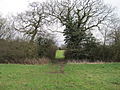
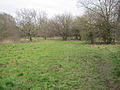
Copthall South Fields is a six hectare [1] Site of Local Importance for Nature Conservation, next to Fiveways Corner on the A1, in Mill Hill in the London Borough of Barnet. [2]

Contents

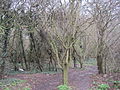
It has several fields with scattered trees and ancient hedgerows. The trees are mainly oak, ash and field maple. The fields contain wild flowers such as meadow vetchling and meadow buttercup, and there are stands of tall herbs. A small plot of native woodland has been planted in the northern field by Watling Chase Community Forest. [3]

There is access from Page Street, near Fiveways Corner, and from Champions Way.

See also

Related Research Articles

<span class="mw-page-title-main">Dollis Brook</span>

Dollis Brook runs through the London Borough of Barnet in north London. It is a tributary of the River Brent, which is itself a tributary of the River Thames. The Dollis Valley Greenwalk follows almost all of Dollis Brook, apart from a short section at the beginning which passes through private land, and the London Loop follows it as far as Barnet Lane. The name Dollis is probably derived from the Middle English word 'dole', meaning the shares of land in the common field.

<span class="mw-page-title-main">Folly Brook</span>

Folly Brook is a 2+14-mile (3.6 km) long brook in the London Borough of Barnet. It is a tributary of Dollis Brook, which is a tributary of the River Brent, which is a tributary of the River Thames. Folly Brook is lined for most of its length by narrow strips of woodland and scrub, with a good variety of trees and shrubs. It is one of the best streams in Barnet for small aquatic invertebrates, including several species of caddis fly and a stonefly, which are only found in unpolluted waters.

<span class="mw-page-title-main">Edgwarebury Park</span>

Edgwarebury Park is a 22-hectare park in Edgware in the London Borough of Barnet. It was once part of the manor of Earlsbury, which was first mentioned in 1216. In the later Middle Ages it was owned by All Souls College, Oxford, and there is still evidence of the older landscape of fields and woodland. Hendon Rural District and Middlesex County Council bought the land in two parts in 1929 and 1932, and the park opened in the latter year. It is now owned and managed by Barnet Council.

<span class="mw-page-title-main">Sunny Hill Park</span>

Sunny Hill Park is a park in Hendon, in the London Borough of Barnet, England. It is a large hilly park, 22 hectares, mainly grassed, which has extensive views to the north and the west. Together with the neighbouring Hendon Churchyard, it is a Site of Local Importance for Nature Conservation.

<span class="mw-page-title-main">Burtonhole Lane and Pasture</span>

Burtonhole Lane and Pasture is a 6.5-hectare (16-acre) Site of Borough Importance for Nature Conservation, Grade II, between Mill Hill and Totteridge in the London Borough of Barnet. It consists of Burtonhole Lane between Partingdale Lane and Burtonhole Close, a footpath east from Burtonhole Lane towards Folly Brook, two fields south of the footpath, and a narrow belt of privately owned woodland north of the footpath. Burtonhole Brook, a tributary of Folly Brook, crosses Burtonhole Lane and the fields.

<span class="mw-page-title-main">Arrandene Open Space and Featherstone Hill</span>

Arrandene Open Space and Featherstone Hill is a 25 hectare Site of Metropolitan Importance for Nature Conservation in Mill Hill in the London Borough of Barnet.

<span class="mw-page-title-main">Scratchwood</span>

Scratchwood is an extensive, mainly wooded, country park in Mill Hill in the London Borough of Barnet. The 57-hectare site is a Site of Metropolitan Importance for Nature Conservation and together with the neighbouring Moat Mount Open Space. It is a Local Nature Reserve.

<span class="mw-page-title-main">Rowley Lodge Field</span>

Rowley Lodge Field is a Site of Borough Importance for Nature Conservation, Grade II, in Arkley in the London Borough of Barnet.

<span class="mw-page-title-main">Arkley Lane and Pastures</span>

Arkley Lane and Pastures is a 50-hectare Site of Borough Importance for Nature Conservation, Grade II, in Arkley in the London Borough of Barnet. Arkley Lane, off Barnet Road, is an old drovers' road. Located on the Barnet Plateau, it is now a quiet country lane with a traditional bank and ditch. The thick hedges are composed of beech and hornbeam, ash, field maple and magnificent old pedunculate oaks.

<span class="mw-page-title-main">Oak Hill Wood</span>

Oak Hill Wood is a 10-hectare Local Nature Reserve (LNR) and a Site of Borough Importance for Nature Conservation Grade I, in East Barnet, London. It is owned by the London Borough of Barnet, and part of it is a 5.5-hectare nature reserve managed by the London Wildlife Trust.

<span class="mw-page-title-main">Copthall Railway Walk and Copthall Old Common</span> Nature reserve and abandoned railway in the London Borough of Barnet

Copthall Railway Walk and Copthall Old Common is a 9-hectare (22-acre) Site of Borough Importance for Nature Conservation, Grade II, in Mill Hill in the London Borough of Barnet.

<span class="mw-page-title-main">Totteridge Green</span>

Totteridge Green is a five hectare Site of Borough Importance for Nature Conservation, Grade II, in Totteridge in the London Borough of Barnet. It is also registered common land.

<span class="mw-page-title-main">Totteridge Common</span>

Totteridge Common is a 3.7 hectare Site of Borough Importance for Nature Conservation, Grade II, in Totteridge in the London Borough of Barnet. The nature reserve is the southern verge of the road Totteridge Common, between Totteridge Park and Oak Lodge. It is registered common land owned by the Totteridge Manor Association and comprised the lands of the former Manor of Totteridge which were transferred to the association in 1954.

<span class="mw-page-title-main">Deans Brook</span>

Deans Brook is a two-kilometre-long stream which runs between Mill Hill and Edgware in the London Borough of Barnet. It is a tributary of the Silk Stream, which is a tributary of the River Brent, which is a tributary of the River Thames.

<span class="mw-page-title-main">Drivers Hill</span>

Drivers Hill is a ten hectare Site of Borough Importance for Nature Conservation, Grade II, in Mill Hill in the London Borough of Barnet. It is owned by the Jehovah's Witnesses, who built their national headquarters, Watch Tower House, on the site in 1955. The house is a major printing works where 120 million Jehovah's Witnesses periodicals were printed in 2002.

<span class="mw-page-title-main">Mutton Brook</span>

Mutton Brook is a stream which runs between East Finchley and Hendon in the London Borough of Barnet. It is a tributary of the River Brent, which is itself a tributary of the River Thames.

<span class="mw-page-title-main">Clay Lane</span> Footpath and bridleway in Edgware, London

Clay Lane is a one kilometre long public footpath and bridle way in Edgware in the London Borough of Barnet. It is a Site of Local Importance for Nature Conservation.

<span class="mw-page-title-main">Burnt Oak Brook</span> Stream in the London Borough of Barnet

Burnt Oak Brook is a one-mile-long stream between Mill Hill and Burnt Oak in the London Borough of Barnet. It is a tributary of the Silk Stream, which is a tributary of the River Brent, which is a tributary of the River Thames.

<span class="mw-page-title-main">Big Wood and Little Wood</span> Small forested areas in London, England

Big Wood and Little Wood are two patches of woodland in Hampstead Garden Suburb in the London Borough of Barnet. They are a Site of Borough Importance for Nature Conservation, Grade 1, and a Local Nature Reserve. Big Wood is 7.3 hectares and Little Wood is 1.2 hectares.

References

  1. Mill Hill East Environmental Statement
  2. "iGiGL – helping you find London's parks and wildlife sites". Greenspace Information for Greater London. 2006. Archived from the original on 2012-10-15.
  3. "Copthall South Fields". Greenspace Information for Greater London. 2006. Archived from the original on 2012-12-24. Retrieved 7 September 2012.

Further reading

Coordinates: 51°36′07″N0°13′59″W / 51.602°N 0.233°W / 51.602; -0.233