Edgware is a suburban town in northern Greater London, mostly in the London Borough of Barnet but with some parts falling in the London Borough of Harrow. Edgware is centred 9.5 miles (15.3 km) north-northwest of Charing Cross and has its own commercial centre. Edgware has a generally suburban character, typical of the rural-urban fringe. It was an ancient parish in the county of Middlesex directly east of the ancient Watling Street, and gives its name to the present day Edgware Road that runs from central London towards the town. The community benefits from some elevated woodland on a high ridge marking the Hertfordshire border of gravel and sand.
Hendon is an urban area in the Borough of Barnet, northwest London 7 miles (11 km) northwest of Charing Cross. Hendon was an ancient manor and parish in the county of Middlesex and a former borough, the Municipal Borough of Hendon; it has been part of Greater London since 1965. Hendon falls almost entirely within the NW4 postcode, while the West Hendon part falls in NW9. Colindale to the northwest was once considered part of Hendon but is today separated by the M1 motorway.

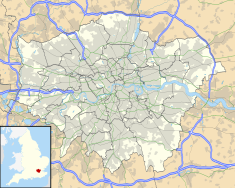
The London Borough of Barnet is a local authority area on the northern outskirts of London. The borough was formed in 1965 from parts of the ceremonial counties of Middlesex and Hertfordshire. It is the second largest London borough by population with 389,344 inhabitants as of 2021, also making it the 17th largest district in England. The borough covers an area of 86.74 square kilometres (33 sq mi), the fourth highest of the 32 London boroughs, and has a population density of 45.8 people per hectare, which ranks it 25th.

Watling Street is a historic route in England that crosses the River Thames at London and which was used in Classical Antiquity, Late Antiquity, and throughout the Middle Ages. It was used by the ancient Britons and paved as one of the main Roman roads in Britannia. The route linked Dover and London in the southeast, and continued northwest via St Albans to Wroxeter. The line of the road was later the southwestern border of the Danelaw with Wessex and Mercia, and Watling Street was numbered as one of the major highways of medieval England.

Badbury Rings is an Iron Age hill fort and Scheduled Monument in east Dorset, England. It was in the territory of the Durotriges. In the Roman era a temple was located immediately west of the fort, and there was a Romano-British town known as Vindocladia a short distance to the south-west.
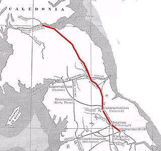
Dere Street or Deere Street is a modern designation of a Roman road which ran north from Eboracum (York), crossing the Stanegate at Corbridge and continuing beyond into what is now Scotland, later at least as far as the Antonine Wall. It was the Romans' major route for communications and supplies to the north and to Scotland. Portions of its route are still followed by modern roads, including the A1(M), the B6275 road through Piercebridge, where Dere Street crosses the River Tees, and the A68 north of Corbridge in Northumberland.

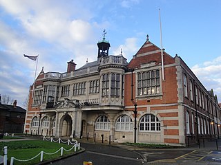
Hendon was an ancient civil parish of around 8,250 acres (33 km2) which included Mill Hill on the border of Hertfordshire, as well as Golders Green and Childs Hill on the border of what became the County of London. In 1894 it was created an urban district of Middlesex and in 1932 it became a municipal borough. The municipal borough was abolished in 1965 and the area became part of the London Borough of Barnet.
The London Borough of Barnet, located on the northern periphery of London and having much of the area within its boundaries in the Metropolitan Green Belt, has many parks and open spaces. In addition there are large areas taken over by cemeteries and golf courses, and part of Hampstead Heath.
Lindum Colonia was the Roman settlement which is now the City of Lincoln in Lincolnshire. It was founded as a Roman Legionary Fortress during the reign of the Emperor Nero or possibly later. Evidence from Roman tombstones suggests that Lincoln was first garrisoned by the Ninth Legion Hispana, which probably moved from Lincoln to found the fortress at York around c. 71 AD. Lindum was then garrisoned by the Second Legion Adiutrix, which then went on to Chester in 77–78 AD.
Durocornovium was a Roman town in Britain, situated on the Roman road between Corinium Dobunnorum (Cirencester) and Calleva Atrebatum (Silchester). In many ways Durocornovium was a typical small Roman town.

Sunny Hill Park is a park in Hendon, in the London Borough of Barnet, England. It is a large hilly park, 22 hectares, mainly grassed, which has extensive views to the north and the west. Together with the neighbouring Hendon Churchyard, it is a Site of Local Importance for Nature Conservation.

Moat Mount Open Space is a 110-hectare park and nature reserve in Mill Hill in the London Borough of Barnet. It is part of Moat Mount Open Space and Mote End Farm Site of Borough Importance for Nature Conservation, Grade II, which includes Barnet Gate Wood and Scratchwood Countryside Park, but is separate from Scratchwood itself, which is a neighbouring park and nature reserve. Most of the site is open to the public, but Mote End Farm and some other areas are private. Scratchwood and Moat Mount are a Local Nature Reserve.

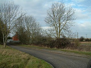
Brockley Hill, Stanmore, is an area of high ground on the outskirts of North London, England. The hill, which rises to 136 metres (446 ft) above sea level, is traversed by the A5 road. It follows the course of the Roman road known as Watling Street. The hill is also associated with the Roman archaeological site called Sulloniacis. The Royal National Orthopaedic Hospital is based at Brockley Hill.

The Silk Stream is a brook just over 4 kilometres (2.5 mi) long in the London Borough of Barnet. It is one of the major components of the Blue Ribbon Network.
Cataractonium was a fort and settlement in Roman Britain. The settlement evolved into Catterick, located in North Yorkshire, England.

Arkley is a village in Greater London, England, within the London Borough of Barnet. It is located 10.6 miles (17.1 km) north-northwest of Charing Cross.
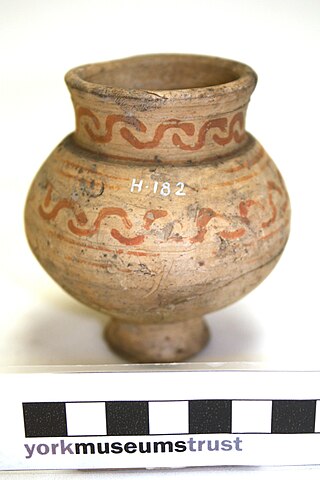
Hendon and District Archaeological Society (HADAS) is an amateur archaeological society based in the London Borough of Barnet, England, and is registered as a charity with the UK Charity Commission.

Edgware Way Grassland or Edgware Way Rough is a 6.7-hectare (17-acre) Site of Metropolitan Importance for Nature Conservation in Edgware in the London Borough of Barnet. It is traversed by Edgwarebury Brook and contains traces of a planned railway viaduct and embankment. This was part of a planned extension of the Northern line from Edgware to Bushey, which was cancelled when the introduction of the Green Belt after the Second World War led to the cancellation of the developments which the railway was to serve. Part of the site is the Environment Agency's Edgwarebury Park Flood Storage Area.

The Derby Racecourse Roman settlement was the third settlement in Derby or Derventio which was a small town in the Roman province of Britannia. It lies 600m east of Derventio fort in Little Chester, on the outskirts of Derby, in the English county of Derbyshire. The Roman road from Derventio to Sawley on the River Trent passes the settlement. It is a scheduled National Monument.
Crambeck Ware is a type of Romano-British ceramic produced in North Yorkshire primarily in the 4th century AD.