
The London Borough of Barnet is a suburban London borough in North London. The borough was formed in 1965 from parts of the ceremonial counties of Middlesex and Hertfordshire. It forms part of Outer London and is the second largest London borough by population with 389,344 inhabitants, also making it the 17th largest district in England. The borough covers an area of 86.74 square kilometres (33 sq mi), the fourth highest of the 32 London boroughs, and has a population density of 45.8 people per hectare, which ranks it 25th.

Dollis Brook runs through the London Borough of Barnet in north London. It is a tributary of the River Brent, which is itself a tributary of the River Thames. The Dollis Valley Greenwalk follows almost all of Dollis Brook, apart from a short section at the beginning which passes through private land, and the London Loop follows it as far as Barnet Lane. The name Dollis is probably derived from the Middle English word 'dole', meaning the shares of land in the common field.
The London Borough of Barnet, located on the northern periphery of London and having much of the area within its boundaries in the Metropolitan Green Belt, has many parks and open spaces. In addition there are large areas taken over by cemeteries and golf courses, and part of Hampstead Heath.

Folly Brook is a 2+1⁄4-mile (3.6 km) long brook in the London Borough of Barnet. It is a tributary of Dollis Brook, which is a tributary of the River Brent, which is a tributary of the River Thames. Folly Brook is lined for most of its length by narrow strips of woodland and scrub, with a good variety of trees and shrubs. It is one of the best streams in Barnet for small aquatic invertebrates, including several species of caddis fly and a stonefly, which are only found in unpolluted waters.

Moat Mount Open Space is a 110-hectare park and nature reserve in Mill Hill in the London Borough of Barnet. It is part of Moat Mount Open Space and Mote End Farm Site of Borough Importance for Nature Conservation, Grade II, which includes Barnet Gate Wood and Scratchwood Countryside Park, but is separate from Scratchwood itself, which is a neighbouring park and nature reserve. Most of the site is open to the public, but Mote End Farm and some other areas are private. Scratchwood and Moat Mount are a Local Nature Reserve.
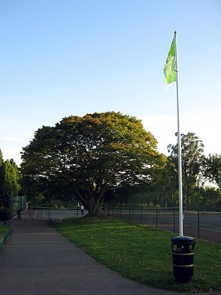
Hendon Park is a 12 hectare London suburban park situated 7 miles (11 km) north west of Charing Cross. It borders the Northern line, and Hendon Park and Northern line Railway Cutting are a Site of Local Importance for Nature Conservation.

The Dollis Valley Greenwalk is a footpath route in the London Borough of Barnet in London, England, between Moat Mount Nature Reserve in Mill Hill and Hampstead Heath. The route is designed to act as a link between the Capital Ring and the London Loop, and between the many green spaces and wildlife corridors along the way. It is approximately 10 miles (16 km) long. It mainly follows the Dollis Brook and is one of the many parks and open spaces in Barnet.

Barnet Gate Wood is a public open space in Barnet Gate, Barnet, London. It is owned and managed by the London Borough of Barnet, and is part of the Watling Chase Community Forest.

Woodridge Nature Reserve or Woodridge School Nature Reserve is a 0.7-hectare (1.7-acre) Site of Local Importance for Nature Conservation in Woodside Park, London, owned and managed by the London Borough of Barnet. It was designed as a nature trail for local primary schools, but is now very neglected.

Rowley Green Common is a six hectare Local Nature Reserve and a Site of Importance Metropolitan for Nature Conservation in Arkley, north London. It is owned by the London Borough of Barnet. It is also registered common land.

Hadley Green is a 10-hectare (25-acre) Site of Metropolitan Importance for Nature Conservation in Hadley in the London Borough of Barnet. The reserve straddles the Great North Road between Hadley Green Road and Fold Lane.

Scratchwood is an extensive, mainly wooded, country park in Mill Hill in the London Borough of Barnet. The 57-hectare site is a Site of Metropolitan Importance for Nature Conservation and together with the neighbouring Moat Mount Open Space. It is a Local Nature Reserve.

Coppetts Wood and Scrublands is a 14.5-hectare (36-acre) Site of Borough Importance for Nature Conservation, Grade I, between Muswell Hill and Friern Barnet in the London Borough of Barnet. It is part of the Coppetts Wood and Glebelands Local Nature Reserve.

Glebelands is Site of Borough Importance for Nature Conservation, Grade I, in Colney Hatch in the London Borough of Barnet. It is also part of the Coppett's Wood and Glebelands Local Nature Reserve.

Monken Hadley Common lies within the Monken Hadley Conservation Area, and is listed as a “Site of Borough Importance for Nature Conservation, Grade I,” by the London Borough of Barnet. It is registered common land, and it is owned by the Trustees of Monken Hadley Common.
Totteridge Green is a five hectare Site of Borough Importance for Nature Conservation, Grade II, in Totteridge in the London Borough of Barnet. It is also registered common land.

Edgware Way Grassland or Edgware Way Rough is a 6.7-hectare (17-acre) Site of Metropolitan Importance for Nature Conservation in Edgware in the London Borough of Barnet. It is traversed by Edgwarebury Brook and contains traces of a planned railway viaduct and embankment. This was part of a planned extension of the Northern line from Edgware to Bushey, which was cancelled when the introduction of the Green Belt after the Second World War led to the cancellation of the developments which the railway was to serve. Part of the site is the Environment Agency's Edgwarebury Park Flood Storage Area.

Princes Park is a small public park and Site of Local Importance for Nature Conservation in Temple Fortune in the London Borough of Barnet.

Swan Lane Open Space is a public park in Whetstone in the London Borough of Barnet. It is the smallest of Barnet's sixteen 'Premier Parks'. It has a children's playground, a café, and a pond which was formerly used for model boating but is now covered with reeds and water plants. Much of it is mown grass and trees, including giant redwoods and a Cedar of Lebanon, but it also has more natural areas managed for nature conservation.

Brent Park is a small public park of 2.24 hectares in Hendon in the London Borough of Barnet. It is part of the 'Lower Dollis Brook' Site of Borough Importance for Nature Conservation, Grade II.
