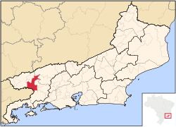
This article needs additional citations for verification .(January 2021) |
Barra Mansa | |
---|---|
Municipality of Barra Mansa | |
Coordinates: 22°32′38″S44°10′15″W / 22.54389°S 44.17083°W | |
Country | Brazil |
Region | Southeast |
State | Rio de Janeiro |
Founded | 1832 |
Area | |
• Total | 547.133 km2 (211.249 sq mi) |
Elevation | 389 m (1,276 ft) |
Population (2020) [2] | |
• Total | 184,833 |
• Density | 340/km2 (870/sq mi) |
Time zone | UTC-3 (UTC-3) |
• Summer (DST) | UTC-2 (UTC-2) |
Postal Code | 27355 |
Area code | +55 24 |
HDI (2010) | 0.729 – high [3] |
Barra Mansa is a municipality located in the Brazilian state of Rio de Janeiro.
It is in the microregion of the Paraíba Valley, within the mesoregion of the South Fluminense. It is located at latitude 22º32'39 "south, longitude 44º10'17" west and altitude of 381 meters. Its estimated population in 2020 was of 184,833 inhabitants, forming a conurbation with the cities of Volta Redonda and Pinheiral with a population of more than 450 thousand inhabitants. It has an area of 548.9 km2.
The administrative and legislative center is in the Centro district. In it are located the city hall and the City Hall). The judicial center is the Barbará neighborhood, where the municipal forum is located.
In 1954 the district of Volta Redonda was emancipated and, in 1991, it was Quatis's turn, taking with him the districts of Ribeirão de São Joaquim and Falcão. In 1993 Antônio Rocha was elevated to the condition of district, as well as the district Santa Rita de Cássia, in 2006.
The population of Barra Mansa is made up of descendants of European immigrants (mainly Portuguese, Italian, and Spanish), but also French and German, as well as a dynamic Syrian-Lebanese colony, as well as Amerindians and African descendants.
The municipality has the second largest population of the South Fluminense mesoregion, has more than 528 industrial units, a large rail, road and river junction. It is located in a privileged area, close to the two largest Brazilian cities: Rio de Janeiro and São Paulo. It is also close to regional economic centers such as São José dos Campos, Juiz de Fora and Volta Redonda. Barra Mansa has a per capita income above the national average of R $13,956.15 [5], and has a Human Development Index (HDI) considered high by the United Nations Development Program (UNDP) of 0.806 (year 2000 ). It is sixth in the ranking of best Human Development Index (HDI-M) among the municipalities of Rio de Janeiro.
Barra Mansa has a strong and traditional shopping center, vital to the municipality's economy.
Around 1700, arriving in São Paulo was an almost impossible task, because of the natural barrier created by the Serra do Mar. But for the trip to become faster, the governor Luís Vaía Monteiro ordered a way through the Itaguaí mountain range.
After completing the route, several incursions were made to the Paraíba do Sul River, but without the commitment to form villages or towns. These incursions were almost always made up of adventurers looking for gold. The first clue to settlement occurred in 1764 when Francisco Gonçalves de Carvalho obtained with the viceroy D. Antônio Álvares da Cunha a sesmaria to found a farm of cattle and supplies (Fazenda da Posse) between the Paraíba River of the South and the river Bananal, exactly in the place where there was a stream called Barra Seca or Barra Mansa.
In 1764, the Vice King of Brazil, Antônio Álvares da Cunha, granted a sesmaria to the farmer Francisco Gonçalves de Carvalho. Thus was born in these lands the first building of the Vila de São Sebastião da Barra Mansa. Built on the banks of the Barra Mansa River and the Paraíba do Sul River, the Posse farm, dating from 1768.
The Barão de Guapi Palace is a historical building of Barra Mansa that received illustrious people like the Princess Isabel. Already hosted the City Hall and the City Hall. It currently houses the Library. In 1765, José Alberto Monteiro also obtained from the viceroy a sesmaria on the bank of the Paraíba River, where it is today the city of Volta Redonda. Over the years, these sesmarias were changed owners, until, around 1827, they arrived, by inheritance, at the hands of Colonel Custódio Ferreira Leite, the Baron of Aiuruoca, founder of the municipality. From there, the site became the obligatory point of passage of troops of travelers on the way to seaports. In 1800, in the lands of Henrique Magalhães, very near the mouth of the river Barra Mansa, already existed a mill and a chapel. Gradually, a small population nucleus began to emerge and the beginning of the settlement encouraged Colonel Custódio Ferreira Leite, who had another chapel built on the right bank of the Paraíba, also dedicated to São Sebastião, located almost in front of Fazenda Ano Bom , on the opposite bank of the river.
The small village grew and on October 3, 1832, thanks to a letter addressed to the General Legislative Assembly of the Empire, the village of São Sebastião de Barra Mansa was created, becoming part of the village dismembered lands of the neighboring Resende, Valença and St. John Mark. In 1954, due to a political maneuver, it had emancipated the until then district of Santo Antônio de Volta Redonda and in 1991 the districts of Quatis, Falcão and Ribeirão de São Joaquim.
The municipality of Barra Mansa covers an area of 548.90 km² and is located on the banks of the Paraíba do Sul River, in the Médio Vale do Paraíba region of Rio de Janeiro, between the Serra do Mar and Serra da Mantiqueira mountains.
Barra Mansa borders 8 municipalities, one of which is in the state of São Paulo
According to the Brazilian Institute of Geography and Statistics - IBGE, the population censused in 2022 was 169,899 inhabitants.
The largest steel mill in Latin America, Companhia Siderúrgica Nacional (CSN), is in its conurbation, located in the municipality of Volta Redonda.
The municipality has a significant river basin and is served by the country's most important railway line (MRS Logística and VLI Logística). In addition, it has an excellent road system, which connects it to the main capitals and cities in the Southeast Region. The Presidente Dutra highway (BR-116) is its central axis.
The municipality enjoys a very privileged geographical position, located 120 kilometers from the city of Rio de Janeiro, 300 kilometers from São Paulo, 460 kilometers from Belo Horizonte, 650 kilometers from Espírito Santo, 85 kilometers from the port of Angra dos Reis and 90 kilometers from the port of Sepetiba, in the municipality of Itaguaí. [4]
Rio de Janeiro is one of the 27 federative units of Brazil. It has the second largest economy of Brazil, with the largest being that of the state of São Paulo. The state, which has 8.2% of the Brazilian population, is responsible for 9.2% of the Brazilian GDP.
Arapeí is a Brazilian municipality of the eastern part of the state of São Paulo. It is part of the Metropolitan Region of Vale do Paraíba e Litoral Norte. The population is 2,460 in an area of 156.90 km². Its bordering cities are Resende and Barra Mansa in the north, Bananal in the southeast and São José do Barreiro in the west.
Município da Estância Turística de Bananal is a city in the state of São Paulo in Brazil. It is part of the Metropolitan Region of Vale do Paraíba e Litoral Norte. The population is 10,993 in an area of 616.43 km2 (238.00 sq mi).
The Paraíba Valley is a landform that encompasses the regions: Paraíba Valley Metropolitan Region and Northern Coast, in the state of São Paulo and Sul-Fluminense Region, in the state of Rio de Janeiro, which stands out for concentrating a considerable portion of the Brazilian economy.
Volta Redonda is the name of a municipality in the Rio de Janeiro state of Brazil with an area of 182.81 km2, located from 350m to 707m above the sea level and with a population of 273,988 inhabitants. The area around the city has nearly 700,000 km2. Its name is due to the round shape of a curve in the Paraíba do Sul river around which the city was built.
The BR-101 is a longitudinal highway of Brazil. It is the longest in the country with a length of nearly 4,800 km (3,000 mi), and it is considered one of the most important highways in the country, along with BR-116.
The Paraíba do Sul, or simply Paraíba, is a river in southeast Brazil. It flows 1,137 km (706 mi) west to northeast from its farthest source at the source of the river Paraitinga to the sea near Campos dos Goytacazes. The river receives its name when it meets the river Paraibuna at the Paraibuna dam.
The Archdiocese of São Sebastião do Rio de Janeiro in Brazil was established as a territorial prelature on July 19, 1575. It was elevated to the status of a diocese on November 16, 1676. It was later elevated to a metropolitan archdiocese on April 27, 1892. On May 6, 2003, the territorial abbey of Nossa Senhora do Monserrate do Rio de Janeiro lost its territorial rank and was added to the archdiocese. Cardinal Orani João Tempesta OCist has been its Archbishop since 2009. Cardinal Eusébio Scheid SCI, who died on January 13, 2021, was Archbishop Emeritus.
The Campeonato Fluminense was the football league of the state of Rio de Janeiro, Brazil, during the period when the Guanabara state and the Rio de Janeiro state were two separated states.
Companhia Siderúrgica Nacional (CSN) lit. 'National Siderurgy Company' or 'National Steel Company' is the largest fully integrated steel producer in Brazil and one of the largest in Latin America in terms of crude steel production. Its main plant is located in the city of Volta Redonda, in the state of Rio de Janeiro. Its current CEO is Benjamin Steinbruch.
Muriaé is a municipality in southeast Minas Gerais state, Brazil. It is located in the Zona da Mata region and its population in 2022 (IBGE) was approximately 104,108 inhabitants.
São José do Barreiro is a municipality in the eastern part of the state of São Paulo, Brazil. The population is 4,144 in an area of 570.69 km2.
The Rodovia Presidente Dutra,, colloquially known as Via Dutra is a federal highway which runs through the eastern part of the state of São Paulo and southwestern region of the state of Rio de Janeiro. It is the part of the route BR-116 connecting the city of São Paulo to the city of Rio de Janeiro.
The Roman Catholic Diocese of Barra do Piraí–Volta Redonda is a diocese located in the cities of Barra do Piraí and Volta Redonda in the ecclesiastical province of São Sebastião do Rio de Janeiro in Brazil.
The Roman Catholic Diocese of Itaguaí is located in the ecclesiastical province of São Sebastião do Rio de Janeiro in Brazil.
The Tietê Bus Terminal is the largest bus terminal in Latin America, and the second largest in the world, after the Port Authority Bus Terminal in New York City. The terminal is located in the Santana district in the city of São Paulo, Brazil. The official name in Portuguese is Terminal Rodoviário Governador Carvalho Pinto, named after Carlos Alberto Alves de Carvalho Pinto, a former Governor of the State of São Paulo.
BR-393, a.k.a. Rodovia Lúcio Meira is a federal highway that begins in Cachoeiro de Itapemirim, Espírito Santo and ends in Barra Mansa, Rio de Janeiro. The highway also serves the municipalities of Itaperuna, Três Rios, and Volta Redonda in Rio de Janeiro. Oficialmente a rodovia não chega a cidade de Cachoeiro do Itapemirim,sendo Denominada com Vários nomes,tais como primeiramente como antiga Rio-Bahia, rodovia do Aço, e posteriormente Lucio Meira a partir do município de Barra Mansa ao distrito de Jamapará, Adentrando em Além Paraíba no estado de Minas Gerais Coincidindo com a BR-116 até a cidade de Pirapetinga, após isso Seu trecho é coincidente a RJ-186 ligando os municípios de Santos Antônio do Pádua a Bom Jesus do Itabapoana.
2018 Area Total
{{cite web}}
: CS1 maint: archived copy as title (link)