Bastelica

Last updated

Bastelica
Bastelica.jpg
A general view of Bastelica
Location of Bastelica
Bastelica
France location map-Regions and departements-2016.svg
Red pog.svg
Bastelica
Corse region location map.svg
Red pog.svg
Bastelica
Coordinates: 42°00′10″N9°03′05″E / 42.0028°N 9.0514°E / 42.0028; 9.0514
Country France
Region Corsica
Department Corse-du-Sud
Arrondissement Ajaccio
Canton Gravona-Prunelli
Intercommunality Celavu-Prunelli
Government
  Mayor (20202026) Jean-Baptiste Giffon [1]
Area
1
127.69 km2 (49.30 sq mi)
Population
 (Jan. 2020) [2]
517
  Density4.0/km2 (10/sq mi)
Time zone UTC+01:00 (CET)
  Summer (DST) UTC+02:00 (CEST)
INSEE/Postal code
2A031 /20119
Elevation306–2,347 m (1,004–7,700 ft)
(avg. 808 m or 2,651 ft)
1 French Land Register data, which excludes lakes, ponds, glaciers > 1 km2 (0.386 sq mi or 247 acres) and river estuaries.

Bastelica is a commune in the Corse-du-Sud department of France on the island of Corsica. [3]

Contents

It was the birthplace of Sampiero Corso.

The inhabitants of the commune are known as Bastelicais, Bastelicaises, or Bastilcacci. [4]

Geography

Bastelica is located in the interior of the island in the high valley of the Prunelli south-west of the Monte Renoso massif of which it shares the summit at 2,352 metres (7,717 ft) of Monte Renoso with Bocognano and Ghisoni. It is also part of the Regional Natural Park of Corsica. It is some 18 km east of Ajaccio (in a straight line). It has many pastures planted with chestnut trees.

Access to the commune is by the D27 from Cauro in the south-west which passes through the length of the commune and the village before continuing north to Bocognano. The D27A goes east from the village to the mountain heights but has no exit. The D3 branches from the D27 south of the village and goes south-west to join the Route nationale N196 near Ajaccio. Apart from the village there are the hamlets of Vignola and Radicale to the south. The commune is rugged and mountainous. [5] [6]

Bastelica has no less than 16 adjacent communes and is one of the six communes in the Community of communes of the Valley of the Prunelli. It was once the chief town of the Canton but is now a part of the Canton of Gravona-Prunelli which has its seat in Afa.

The intersection of the 42nd parallel North and the 9th meridian East of Greenwich is in the commune (see the Degree Confluence Project).

Climate

Bastelica has a warm-summer mediterranean climate (Köppen climate classification Csb). The average annual temperature in Bastelica is 12.5 °C (54.5 °F). The average annual rainfall is 1,332.8 mm (52.47 in) with December as the wettest month. The temperatures are highest on average in August, at around 21.1 °C (70.0 °F), and lowest in January, at around 5.2 °C (41.4 °F). The highest temperature ever recorded in Bastelica was 40.0 °C (104.0 °F) on 23 July 2009; the coldest temperature ever recorded was −12.0 °C (10.4 °F) on 11 February 1986.

Climate data for Bastelica (1981–2010 averages, extremes 1959–present)
MonthJanFebMarAprMayJunJulAugSepOctNovDecYear
Record high °C (°F)23.5
(74.3)
22.0
(71.6)
28.0
(82.4)
32.0
(89.6)
32.0
(89.6)
35.2
(95.4)
40.0
(104.0)
39.5
(103.1)
36.5
(97.7)
32.0
(89.6)
25.0
(77.0)
21.0
(69.8)
40.0
(104.0)
Average high °C (°F)9.7
(49.5)
10.2
(50.4)
12.8
(55.0)
15.1
(59.2)
20.0
(68.0)
24.0
(75.2)
28.0
(82.4)
28.1
(82.6)
24.0
(75.2)
19.6
(67.3)
13.8
(56.8)
10.6
(51.1)
18.0
(64.4)
Daily mean °C (°F)5.2
(41.4)
5.4
(41.7)
7.6
(45.7)
9.8
(49.6)
14.2
(57.6)
17.9
(64.2)
21.0
(69.8)
21.1
(70.0)
17.6
(63.7)
14.1
(57.4)
9.1
(48.4)
6.3
(43.3)
12.5
(54.5)
Average low °C (°F)0.7
(33.3)
0.6
(33.1)
2.4
(36.3)
4.5
(40.1)
8.4
(47.1)
11.8
(53.2)
14.0
(57.2)
14.2
(57.6)
11.1
(52.0)
8.5
(47.3)
4.4
(39.9)
2.0
(35.6)
6.9
(44.4)
Record low °C (°F)−11.0
(12.2)
−12.0
(10.4)
−9.0
(15.8)
−3.0
(26.6)
−1.0
(30.2)
2.0
(35.6)
3.8
(38.8)
5.0
(41.0)
2.0
(35.6)
−2.1
(28.2)
−7.1
(19.2)
−9.8
(14.4)
−12.0
(10.4)
Average precipitation mm (inches)125.2
(4.93)
111.5
(4.39)
109.1
(4.30)
130.5
(5.14)
95.6
(3.76)
53.7
(2.11)
25.2
(0.99)
38.4
(1.51)
97.7
(3.85)
146.1
(5.75)
196.8
(7.75)
203.0
(7.99)
1,332.8
(52.47)
Average precipitation days (≥ 1.0 mm)10.19.99.511.79.15.62.74.17.510.011.711.7103.5
Source: Meteo France [7]

Administration

The Town Hall Bastelica MC1 JPG.jpg
The Town Hall

List of Successive Mayors [8]

FromToNameParty
1879Alexandre Bolelli
20012026Jean-Baptiste Giffon DVD

Demography

In 2017 the commune had 533 inhabitants.

Historical population
YearPop.±% p.a.
1800 1,790    
1806 1,798+0.07%
1821 2,017+0.77%
1831 2,314+1.38%
1836 2,375+0.52%
1841 2,420+0.38%
1846 2,528+0.88%
1851 2,605+0.60%
1856 3,003+2.88%
1861 3,071+0.45%
1866 2,842−1.54%
1872 2,934+0.53%
1876 2,958+0.20%
1881 3,196+1.56%
1886 3,277+0.50%
1891 3,367+0.54%
1896 3,341−0.15%
1901 3,582+1.40%
YearPop.±% p.a.
1906 3,689+0.59%
1911 3,938+1.31%
1921 3,661−0.73%
1926 3,925+1.40%
1931 4,125+1.00%
1936 4,152+0.13%
1946 3,367−2.07%
1954 2,172−5.33%
1962 833−11.29%
1968 774−1.22%
1975 762−0.22%
1982 766+0.07%
1990 436−6.80%
1999 460+0.60%
2007 525+1.67%
2012 537+0.45%
2017 533−0.15%
Source: EHESS [9] and INSEE [10]
The War Memorial Bastelica monument aux morts.jpg
The War Memorial

Education

The commune has a public primary school. [11]

Sports

The Val d'Ese ski resort is located in the commune.

Culture and heritage

Boccialacce Fountain Bastelica fontaine de Boccialacce.jpg
Boccialacce Fountain
Fountain-Lavoir of Dominicacci Bastelica fontaine-lavoir de Dominicacci.jpg
Fountain-Lavoir of Dominicacci
The monument to Sampiero Corso Bastelica sampiero corso statue.JPG
The monument to Sampiero Corso
The Genovese Bridge 0 Bastelica - Pont genois de Zippitoli (1).JPG
The Genovese Bridge

Civil heritage

The commune has two sites that are registered as historical monuments:

Religious heritage

The Chapel of the Annunciation Bastelica l'Anunciata.jpg
The Chapel of the Annunciation
The Church of Saint-Michel Bastelica eglise.JPG
The Church of Saint-Michel
The interior of the church Bastelica interieur eglise Saint-Michel.jpg
The interior of the church

Environmental heritage

Bastelica is part of the Regional Natural Park of Corsica in the "Land of Life" called Gravona. [20]

Zone of Ecological Interest, Flora and Fauna (ZNIEFF)

The commune has eight 2nd generation ZNIEFF areas:

Natura 2000 sites

Notable people linked to the commune

See also

Related Research Articles

<span class="mw-page-title-main">Afa, Corse-du-Sud</span> Commune in Corsica, France

Afa a commune in the Corse-du-Sud department on the island and collectivity of Corsica, France.

<span class="mw-page-title-main">Alata, Corse-du-Sud</span> Commune in Corsica, France

Alata is a commune in the Corse-du-Sud department, on the French island of Corsica. It is within the metropolitan area of the capital Ajaccio.

<span class="mw-page-title-main">Arro</span> Commune in Corsica, France

Arro is a commune in the French department of Corse-du-Sud, collectivity and island of Corsica.

<span class="mw-page-title-main">Sampiero Corso</span> Corsican military leader

Sampiero Corso was a Corsican soldier, father of the Marshal of France Alphonse d'Ornano.

<span class="mw-page-title-main">Asco, Haute-Corse</span> Commune in Corsica, France

Asco is a commune in the Haute-Corse department of France on the island of Corsica.

Bastelicaccia is a commune in the Corse-du-Sud department of France on the island of Corsica.

<span class="mw-page-title-main">Bocognano</span> Commune in Corsica, France

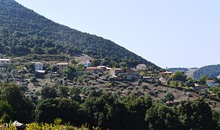
Bocognano is a commune located in the department of Corse-du-Sud, on the island of Corsica, France. The village, situated at the south-western side of the climb to the Col de Vizzavona, belongs to the micro of Celavo which is historically the capital.

<span class="mw-page-title-main">Barbaggio</span> Commune in Corsica, France

Barbaggio is a commune in the French department of Haute-Corse on the island of Corsica. It is known for its wine, its scenery, and the prehistoric site of Strette.

<span class="mw-page-title-main">Gravona</span> River

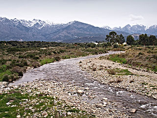
The Gravona is a river on the island of Corsica, France. It flows from the center of the island southwest to the Gulf of Ajaccio. Its entire course is in the Corse-du-Sud Department of France. It is 46.4 km (28.8 mi) long. The Gravona Valley conducts the main highway, Route N193, from the capital city, Ajaccio, to the Col de Vizzavona, where it goes through the pass and down to Corte and Bastia. At its upper end the Gravona is a crystal-clear mountain stream cascading over falls and rapids into trout-filled pools. At its lower end nearly all of the Gravona's flow serves to water the densely urban area of Ajaccio.

<span class="mw-page-title-main">Abatesco</span> River of the Haute-Corse department in Corsica

The Abatesco is a French coastal river which flows through the Haute-Corse department and empties into the Tyrrhenian Sea.

<span class="mw-page-title-main">Étang de Crovani</span> Lagoon in Corsica, France

The Étang de Crovani is a coastal lagoon beside the Mediterranean Sea on the west coast of the Haute-Corse department on the French island of Corsica.

<span class="mw-page-title-main">Fiumorbo</span> River in the department of Haute-Corse, Corsica

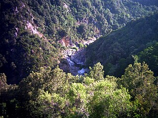
The Fiumorbo is a coastal river in the department of Haute-Corse, Corsica, France. It is dammed in two places to supply irrigation water and hydroelectricity. Between the two dams it runs through the spectacular Défilé de l’Inzecca, a Natura 2000 site.

<span class="mw-page-title-main">Ospedale Reservoir</span> Reservoir in Corse-du-Sud, Corsica

The Ospedale Reservoir is a reservoir in the Corse-du-Sud department of France on the island of Corsica. It holds drinking water for the southeast of the island, including Porto-Vecchio. It is surrounded by a forest that has been designated a Zone naturelle d'intérêt écologique, faunistique et floristique (ZNIEFF).

<span class="mw-page-title-main">Lac de Vitalaca</span> Lake in Corse-du-Sud, Corsica

Lac de Vitalaca is a small lake in the Monte Renoso massif in the Corse-du-Sud department of France. It is at an altitude of 1,777 metres, and is surrounded by high mountains.

<span class="mw-page-title-main">Prunelli</span> River in Corsica, France

The Prunelli is a small coastal river in the department of Corse-du-Sud, Corsica, France. It flows into the Golfe d'Ajaccio on the Mediterranean Sea.

<span class="mw-page-title-main">Seccu</span> Stream in the department of Haute-Corse, Corsica

The Seccu River is a small coastal river in the department of Haute-Corse, Corsica, France.

<span class="mw-page-title-main">Poggiolo (stream)</span> Stream in the department of Haute-Corse, Corsica

The Poggiolo is a small coastal stream in the department of Haute-Corse, Corsica, France. It enters the Tyrrhenian Sea from the east of the Cap Corse peninsula.

<span class="mw-page-title-main">Guadu Grande</span> Stream in the department of Haute-Corse, Corsica

The Guadu Grande is a small coastal stream in the department of Haute-Corse, Corsica, France. It enters the Mediterranean Sea from the west of the Cap Corse peninsula.

<span class="mw-page-title-main">Varagno</span> Stream in the department of Haute-Corse, Corsica

The Varagno is a stream in the department of Haute-Corse, Corsica, France. It is a tributary of the Fiumorbo.

<span class="mw-page-title-main">Monte Renoso</span>

Monte Renoso is a mountain in the departments of Haute-Corse and Corse-du-Sud on the island of Corsica, France. It is the highest peak in the Monte Renoso massif.

References

  1. "Répertoire national des élus: les maires" (in French). data.gouv.fr, Plateforme ouverte des données publiques françaises. 13 September 2022.
  2. "Populations légales 2020". The National Institute of Statistics and Economic Studies. 29 December 2022.
  3. INSEE commune file
  4. Inhabitants of Corse-du-Sud (in French)
  5. Bastelica on Google Maps
  6. Bastelica on the Géoportail from National Geographic Institute (IGN) website (in French)
  7. "Bastelica-Village (20)" (PDF). Fiche Climatologique: Statistiques 1981–2010 et records (in French). Meteo France. Archived from the original (PDF) on 20 October 2019. Retrieved 20 October 2019.
  8. List of Mayors of France (in French)
  9. Des villages de Cassini aux communes d'aujourd'hui: Commune data sheet Bastelica, EHESS (in French).
  10. Population en historique depuis 1968, INSEE
  11. Schools in Bastelica (in French)
  12. Ministry of Culture, Mérimée PA2A000002 Monument to Sampiero Corso (in French)
  13. Ministry of Culture, Mérimée PA00099075 Genovese Bridge (in French)
  14. Ministry of Culture, Palissy PM2A000463 Stations of the Cross (14 stations) (in French)
  15. Ministry of Culture, Palissy PM2A000462 Statue: Virgin and child (in French)
  16. Ministry of Culture, Palissy PM2A000461 Painting: The Calvary (in French)
  17. Ministry of Culture, Palissy PM2A000460 Stoup (in French)
  18. Ministry of Culture, Palissy PM2A000241 Altar and Tabernacle (in French)
  19. Ministry of Culture, Palissy PM2A000061 Statue: Saint Antony of Padua (in French)
  20. The Parc naturel régional de Corse on the INPN website (in French)
  21. ZNIEFF 940004164 Forêt de Pineta-Quarceta et Massif Montagneux de Punta di Forca D'Olmu INPN website (in French)
  22. ZNIEFF 940004165 Forêt des Cinq Communes et Col D'Arusula INPN website (in French)
  23. ZNIEFF 940004165 Hetraie de Bastelica INPN website (in French)
  24. ZNIEFF 940004167 Chataigneraie-Chenaie de Bastelica INPN website (in French)
  25. ZNIEFF 940004167 Cirques et Lacs Glaciaires du Monte Renoso INPN website (in French)
  26. ZNIEFF 940004167 Cretes et Hauts Versants asylvatiques du Monte Renoso INPN website (in French)
  27. ZNIEFF 940004167 Sapinière du Haut Ravin de Marmano INPN website (in French)
  28. ZNIEFF 940004167 Hetraie-Sapinière de Punteniello INPN website (in French)
  29. FR9400611 Massif du Renoso INPN website (in French)
  30. FR9410113 Forêts Territoriales de Corse INPN website (in French)