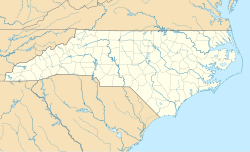
Beaufort is a town in and the county seat of Carteret County, North Carolina, United States. Established in 1713 and incorporated in 1723, Beaufort is the fourth oldest town in North Carolina . On February 1, 2012, Beaufort was ranked as "America's Coolest Small Town" by readers of Budget Travel Magazine.

Beaufort Historic District is a historic district in Beaufort, South Carolina. It was listed on the National Register of Historic Places in 1969, and was declared a National Historic Landmark in 1973.

Bath Historic District is a historic district in Bath, Beaufort County, North Carolina. The district is now a North Carolina Historic Site belonging to the North Carolina Department of Natural and Cultural Resources and known as Historic Bath, and includes a visitor center offering guided tours of the Bonner House and Palmer-Marsh House, which is also a National Historic Landmark. Visitors can also tour the Van der Veer House and St. Thomas Episcopal Church.

The Capitol Area Historic District is a national historic district located at Raleigh, North Carolina. The district encompasses 25 contributing buildings and was developed after 1792. The district includes notable examples of Classical Revival and Late Gothic Revival style architecture. Located in the district are the following separately listed buildings:

This is a list of the National Register of Historic Places listings in Beaufort County, South Carolina.
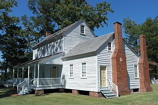
Bonner House is a historic home located at Bath, Beaufort County, North Carolina. It was built about 1835, and is a two-story frame dwelling with a one-story wing and rear shed addition. It sits on a brick pier foundation and has a side-hall plan. It is on land once owned by John Lawson, explorer and founder of Bath.

This list includes properties and districts listed on the National Register of Historic Places in Beaufort County, North Carolina. Click the "Map of all coordinates" link to the right to view an online map of all properties and districts with latitude and longitude coordinates in the table below.

Zion Episcopal Church is a historic Episcopal church complex located near Washington, Beaufort County, North Carolina. It was built in 1856, and is a vernacular Greek Revival style frame building. Also on the property are a contributing church cemetery, rectory (1884-1885), garage, well house, and fence.
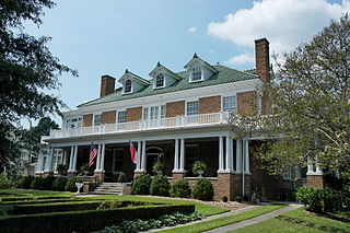
The Bowers–Tripp House is a historic home located at Washington, Beaufort County, North Carolina. It was designed by Benton & Benton and built in 1921 in the Colonial Revival style. The house and a secondary structure were listed as contributing buildings.
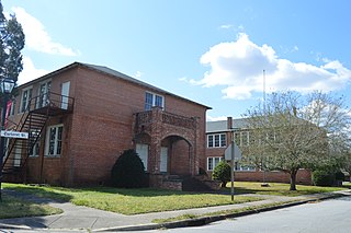
Bath School is a historic school complex located at Bath, Beaufort County, North Carolina. It was built in phases between 1918 and 1966, and consists of two classroom buildings and a classroom and auditorium building connected by a two-story hyphen. Each section is a two-story, brick structure with a hipped roof and Colonial Revival style design details. A kitchen addition was built in 1966. Also on the property are the contributing 1 1/2-story vocational building constructed in 1939 with funds from the Public Works Administration (PWA), one-story shop building built in 1948, and flagpole.

Beaufort County Courthouse is a historic courthouse building located at Washington, Beaufort County, North Carolina. It was built about 1786, as a two-story, square brick building measuring 42 feet by 42 feet. It was later enlarged with a two-by rear extension and square clock tower. It is one of the earliest public buildings in North Carolina.
Rosedale, also known as Wharton House, is a historic plantation house located near Washington, Beaufort County, North Carolina. It is a large 2+1⁄2-story, frame dwelling with Greek Revival and Italianate style design elements. It was built as the home of David Bradley Perry, a prominent Beaufort County planter, and later inherited by United States Congressman and Mrs. John Humphrey Small.

The Port Royal School is a historic South Carolina school building. It is located at 1214 Paris Avenue in the town of Port Royal. Its original main block is a two-story Colonial Revival structure designed by Wilson and Sompayrac and built in 1911. In 1954 a single-story brick Modern addition was added to the north of this building; it was designed by William Harleston of Halsey & Cummings. A second addition was made in 2002, further extending the 1954 building to the north. The building is believed to be the second-oldest active elementary school building in the state. It also contributed to the area's checkered history of the provision of so-called "separate but equal" educational facilities for whites and African Americans: the 1954 addition occurred at a time when the last elementary school for African Americans in Port Royal was closed, requiring the transportation of those students to Beaufort. The Port Royal School remained whites-only until 1964.

Washington Historic District is a national historic district located at Washington, Beaufort County, North Carolina. It encompasses 512 contributing buildings and one contributing structure in the town of Washington. They include a variety of institutional, commercial, and residential buildings primarily dating from the late 19th and early 20th centuries. Notable buildings include the Beaufort County Courthouse, Havens and Fowle warehouses, Mayo Law Office, Marsh House, Myers House, Hyatt House, Griffin House, Rodman House, Elmwood, Firehouse and City Hall, Post Office and Federal Courthouse (1913), railroad station, Presbyterian church, Saint Peter's Episcopal Church, First Methodist Church (1899), Singleton Primitive Baptist Church, Blount-Bragaw Building (1901-1904), Minor House, and George T. Leach House.

North Market Street Historic District is a national historic district located at Washington, Beaufort County, North Carolina. It encompasses 313 contributing buildings, 1 contributing structure, and 3 contributing objects in a primarily residential section of Washington. Known as Nicholsonville, it was first platted in 1893, and enlarged in 1896 and in 1910. Stylistic influences include Late Victorian, Colonial Revival, Neoclassical, and Mission, and the American Craftsman / Bungalow-styles.

Chestnut Hill Historic District is a national historic district located at Asheville, Buncombe County, North Carolina. The district encompasses 238 contributing buildings and 1 contributing structure in a predominantly residential section of Asheville. It was developed in the late-19th and early-20th century and includes Colonial Revival, Queen Anne-influenced, and bracketed Victorian style dwellings. At least eight of the houses were designed by architect Richard Sharp Smith.

North Green Street–Bouchelle Street Historic District is a national historic district located at Morganton, Burke County, North Carolina. It encompasses 37 contributing buildings in a predominantly residential section of Morganton. It includes buildings built between about 1876 and 1935, and includes representative examples of Colonial Revival, Bungalow / American Craftsman, and Late Victorian style architecture. Located in the district is the separately listed Alphonse Calhoun Avery House.
Snow Hill Historic District is a national historic district located at Snow Hill, Greene County, North Carolina. The district encompasses 229 contributing buildings, a contributing site, two contributing structures, and a contributing object in the central business district and surrounding residential sections of Snow Hill. The buildings are in a variety of popular 19th and early-20th century architectural styles including Greek Revival, Gothic Revival, Colonial Revival, and, Bungalow / American Craftsman. Located in the district are the separately listed Greene County Courthouse and St. Barnabas Episcopal Church. Other notable buildings include J. Exum & Co. Grocery building, Harper Drugstore, Sugg-Harper House, Williams-Exum Housem, Murphrey-Morrill House (1885), Josiah Exum House (1887-1888), Alfred Warren House (1912-1915), Calvary Memorial Methodist Church (1928), Snow Hill Presbyterian Church (1935), and former First Baptist Church.

Swansboro Historic District is a national historic district located at Swansboro, Onslow County, North Carolina. The district encompasses 74 contributing buildings and 1 contributing site in the central business district and surrounding residential sections of Swansboro. The district largely developed between 1890 and 1925 and includes notable examples of Federal, Greek Revival, and Bungalow / American Craftsman style architecture. Notable contributing buildings include the Jonathan Green House, Beaufort House, Bazel Hawkins House, George E. Bell House, James Elijah Parkin House (1893), William Pugh Ferrand Store (1839), the Robert Spence McLean Store, Watson and Parkin "double store" (1910), Jim Kennedy Fish House (1930s), Baptist Church (1897), and the Emmerton School (1920s).

Mordecai Place Historic District is a historic neighborhood and national historic district located at Raleigh, North Carolina. The district encompasses 182 contributing buildings and 1 contributing object in the most architecturally varied of Raleigh's early-20th century suburbs for the white middle-class. Mordecai Place was listed on the National Register of Historic Places in February 1998, with a boundary increase in 2000.