
Ellison Onizuka Kona International Airport at Keāhole is the busiest airport on the Island of Hawaiʻi. It is located in Kalaoa CDP, Hawaiʻi County, Hawaiʻi, United States, near the town of Kailua-Kona. The airport serves leeward (western) Hawaiʻi island, including the resorts of the North Kona and South Kohala districts. It is one of two international airports serving Hawaiʻi island, the other being Hilo International Airport on the windward side.

Monterey Regional Airport is three miles (5 km) southeast of Monterey, in Monterey County, California, United States. It was created in 1936 and was known as the Monterey Peninsula Airport until the board of directors renamed it on September 14, 2011.

Santa Monica Airport is a general aviation airport largely in Santa Monica, California, United States. The airport is about 2 miles (3 km) from the Pacific Ocean and 6 miles (10 km) north of Los Angeles International Airport. The FAA's National Plan of Integrated Airport Systems for 2009–2013 categorized it as a reliever airport. The airport is scheduled to remain open until 2028. Santa Monica Airport covers a total of 215 acres of land.
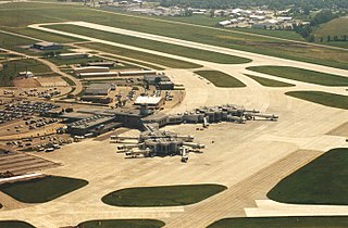
Green Bay–Austin Straubel International Airport is a county-owned public-use airport in Brown County, Wisconsin, United States, which serves Northeastern Wisconsin. It is the fourth busiest of eight commercial service airports in Wisconsin in terms of passengers served. The airport is located 7 nautical miles southwest of downtown Green Bay, in the village of Ashwaubenon. It is included in the Federal Aviation Administration (FAA) National Plan of Integrated Airport Systems for 2021–2025, in which it is categorized as a non-hub primary commercial service facility. The airport sits on portions of land encompassing Green Bay and the Oneida Nation of Wisconsin's Indian reservation. It has two runways and is used for commercial air travel and general aviation. There are two concourses with six gates each. The airport is named for Lt. Col. Austin Straubel, the first aviator from Brown County to die in his country's service on February 3, 1942, after having served for thirteen years in the United States Army Air Corps. The airport name was officially changed to Green Bay–Austin Straubel International Airport on August 17, 2016.

Fort Lauderdale Executive Airport is a general aviation airport located within the city limits of Fort Lauderdale, in Broward County, Florida, United States, five miles (8.0 km) north of downtown Fort Lauderdale. It is a division of the Transportation and Mobility Department of the City of Fort Lauderdale.
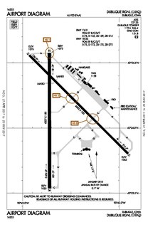
Dubuque Regional Airport is a regional airport located eight miles south of Dubuque, in Dubuque County, Iowa. On U.S. Highway 61, the airport is owned by the city of Dubuque and is operated as a department of the city government. The city council appoints people for four-year terms to the Airport Commission board, which oversees the airport. For day-to-day operations, the Commission hires an airport manager. DBQ is used for general aviation and sees one airline. A charter service is run by Sun Country Airlines. The airport offers maintenance and refueling services, including service for jets.

Chicago Executive Airport, formerly Palwaukee Municipal Airport, is a public airport 18 miles (33 km) northwest of Chicago, in the village of Wheeling in Cook County, Illinois, United States. It is owned by the City of Prospect Heights and the Village of Wheeling.

Floyd Bennett Memorial Airport is a county-owned, public-use airport in Warren County, New York, United States. It is located three nautical miles (6 km) northeast of the central business district of Glens Falls, in the town of Queensbury. This airport is included in the National Plan of Integrated Airport Systems for 2011–2015, which categorized it as a general aviation facility.

Addison Airport is a public airport in Addison, in Dallas County, Texas, United States, 9 mi north of downtown Dallas. It opened in 1954 and was purchased by the town of Addison in 1976. It is home to the Cavanaugh Flight Museum.
Mansfield Municipal Airport is a public airport located 2 mi southeast of the central business district of Mansfield, a town in Bristol County, Massachusetts, United States. During World War II, the airfield was Naval Outlying Landing Field Mansfield.

Montgomery-Gibbs Executive Airport, formerly known as Montgomery Field and Gibbs Field, is a public airport in San Diego, California, United States, six miles (10 km) north of downtown San Diego. The airport covers 456 acres (185 ha) and has three runways, one public and two private helipads. The runways are 28 Right/10 Left-28 Left/10 Right parallels and 05/23.

South Bend International Airport is a commercial and freight airport located three miles northwest of downtown South Bend, in St. Joseph County, Indiana, United States. It is the state's second busiest airport in terms of passenger traffic after Indianapolis International Airport.

Zamperini Field is a public airport three miles (5 km) southwest of downtown Torrance, in Los Angeles County, California, United States.

Ocean City Municipal Airport is the only airport located on a New Jersey barrier island. Named Clarke Field after a Naval commander, the public airport is located two nautical miles southwest of the central business district of Ocean City, in Cape May County, New Jersey, United States. It is owned by the City of Ocean City. It was built between 1934 and 1935 with funds from the Civil Works Administration.

Simsbury Airport is a public use airport located in Simsbury and East Granby, both towns in Hartford County, Connecticut, United States. It is privately owned by the Airport Realty Association, LLC. The airport is operated by the Simsbury Flying Club, a not-for-profit group that operates an FBO at the airport. It is included in the Federal Aviation Administration (FAA) National Plan of Integrated Airport Systems for 2017–2021, in which it is categorized as a general aviation facility.
Walker County Airport, also known as Bevill Field, is a public airport located five miles (8 km) northwest of the central business district of Jasper, a city in Walker County, Alabama, United States. It is owned by the Walker County Commission.

Valley Hospital Medical Center established Southern Nevada's first air ambulance service, Flight for Life, in 1980. Metro Aviation sold the program to Mercy Air on December 4, 2001, effectively shutting down the Flight for Life service under that name, although the service was still provided.
Capitol Airport is a public use airport located three nautical miles (6 km) east of the central business district of Brookfield, a city in Waukesha County, Wisconsin, United States. It is privately owned by Wisconsin Aviation Investments LLC. The airport is also known as, or formerly known as, Capitol Drive Airport.
Perris Valley Airport is a privately owned and operated airport open to public use and located one mile (1.6 km) southeast of Perris, serving Riverside County, California, United States. It has one runway and is used for general aviation and extensive skydiving. The airport operates from dawn to dusk daily year-round.

Parker County Airport is a privately owned public airport in Hudson Oaks, Parker County, Texas, United States. The airport serves the city of Weatherford, and is located approximately 5 nautical miles (9.3 km) east of the central business district.

