Bellville, Georgia

Last updated

Bellville, Georgia
Bellville City Hall.JPG
Motto: 
Fides Veritas Heriditas
Evans County Georgia Incorporated and Unincorporated areas Bellville Highlighted.svg
Location in Evans County and the state of Georgia
Coordinates: 32°9′10″N81°58′24″W / 32.15278°N 81.97333°W / 32.15278; -81.97333
Country United States
State Georgia
County Evans
Area
[1]
  Total1.01 sq mi (2.62 km2)
  Land0.99 sq mi (2.55 km2)
  Water0.03 sq mi (0.07 km2)
Elevation
184 ft (56 m)
Population
 (2020)
  Total127
  Density128.80/sq mi (49.73/km2)
Time zone UTC-5 (Eastern (EST))
  Summer (DST) UTC-4 (EDT)
ZIP code
30414
Area code 912
FIPS code 13-06688 [2]
GNIS feature ID0354538 [3]
Website georgiainfo.galileo.usg.edu/topics/historical_markers/county/evans/bellville

Bellville is a city in Evans County, Georgia, United States. As of the 2020 census, the city had a population of 127. It is the hometown of film director James Kicklighter. [4]

Contents

History

Bellville was laid out in 1890 when the railroad was extended to that point. [5] Bellville incorporated in 1959. [6] Hines Daniel served as the first Mayor.

Geography

Bellville is located in western Evans County at 32°9′10″N81°58′24″W / 32.15278°N 81.97333°W / 32.15278; -81.97333 (32.152828, -81.973366), [7] along U.S. Route 280, which leads east 4 miles (6 km) to Claxton, the county seat, and southwest 10 miles (16 km) to Reidsville. Georgia State Route 292 branches off US 280 and passes through the center of Bellville, leading west 8 miles (13 km) to Collins. Georgia State Route 169 crosses GA 292 in the center of Bellville, running north–south.

According to the United States Census Bureau, the city has a total area of 1.01 square miles (2.62 km2), of which 0.98 square miles (2.55 km2) is land and 0.03 square miles (0.07 km2), or 2.53%, is water. [8]

Climate

Bellville has a humid subtropical climate according to the Köppen classification. The city has hot and humid summers with average highs of 94 degrees and lows of 70 degrees in July. Winters are mild with average January highs of 61 degrees and lows of 36 degrees. Winter storms are rare, but they can happen on occasion. [9]

Climate data for Bellville, Georgia
MonthJanFebMarAprMayJunJulAugSepOctNovDecYear
Record high °F (°C)81
(27)
86
(30)
89
(32)
96
(36)
98
(37)
106
(41)
107
(42)
105
(41)
104
(40)
96
(36)
87
(31)
84
(29)
107
(42)
Mean daily maximum °F (°C)61
(16)
66
(19)
73
(23)
78
(26)
86
(30)
91
(33)
94
(34)
92
(33)
87
(31)
80
(27)
71
(22)
63
(17)
79
(26)
Mean daily minimum °F (°C)36
(2)
39
(4)
44
(7)
50
(10)
59
(15)
67
(19)
71
(22)
70
(21)
65
(18)
54
(12)
45
(7)
38
(3)
53
(12)
Record low °F (°C)−2
(−19)
13
(−11)
16
(−9)
28
(−2)
41
(5)
48
(9)
58
(14)
56
(13)
45
(7)
30
(−1)
22
(−6)
13
(−11)
−2
(−19)
Average precipitation inches (mm)4.36
(111)
3.57
(91)
3.25
(83)
2.95
(75)
3.21
(82)
5.12
(130)
4.68
(119)
5.41
(137)
3.73
(95)
3.87
(98)
2.49
(63)
3.17
(81)
45.81
(1,165)
Source: The Weather Channel [10]

Demographics

Historical population
CensusPop.Note
1970 234
1980 173−26.1%
1990 19211.0%
2000 130−32.3%
2010 123−5.4%
2020 1273.3%
U.S. Decennial Census [11]
The 1890s railroad depot in Bellville. The town celebrates "Railroad Days" once a year. Bellville-depot.jpg
The 1890s railroad depot in Bellville. The town celebrates "Railroad Days" once a year.

As of the census [2] of 2010, there were 123 people, 54 households, and 42 families residing in the city. By the 2020 census, its population increased to 127.

Related Research Articles

<span class="mw-page-title-main">Wheeler County, Georgia</span> County in Georgia, United States

Wheeler County is a county located in the central portion of the U.S. state of Georgia. As of the 2020 census, the population was 7,471. The county seat is Alamo. The county is one of the most impoverished counties in the nation. The American Community Survey's 2009–2013 average reports that the county's per-capita income of $8,948 makes it the poorest county in the United States by this metric. The measurement however is misleading as Wheeler County is the site of Wheeler Correctional Facility, a large prison with a capacity of 2,874 prisoners, about 40 percent of the county's total population. Most prisoners have little income. The prison was opened in 1998 and the prison population may also account for the increased population of the county in the early 2000s.

<span class="mw-page-title-main">Webster County, Georgia</span> County in Georgia, United States

Webster County is a county located in the west central portion of the U.S. state of Georgia. As of the 2020 Census reflected a population of 2,348, making it the third-least populous county in Georgia. The county seat is Preston.

<span class="mw-page-title-main">Toombs County, Georgia</span> County in Georgia, United States

Toombs County is a county located in the east central portion of the U.S. state of Georgia. As of the 2020 census, the population was 27,030. The county seat is Lyons and the largest city is Vidalia. The county was created on August 18, 1905.

<span class="mw-page-title-main">Tattnall County, Georgia</span> County in Georgia, United States

Tattnall County is a county located in the southeast portion of the U.S. state of Georgia, located within the Magnolia Midlands, a part of the Historic South region. As of the 2020 census, the population was 22,842. The county seat is Reidsville. Tattnall County was created on December 5, 1801, from part of Montgomery County, Georgia by the Georgia General Assembly.

<span class="mw-page-title-main">Evans County, Georgia</span> County in Georgia, United States

Evans County is a county in the southeastern portion of the U.S. state of Georgia. As of the 2020 census, the population was 10,774. The county seat is Claxton. A bill creating the county was passed in the Georgia General Assembly on August 11, 1914, and later, on November 3, 1914, an amendment was ratified by a vote of the people which formally created the county.

<span class="mw-page-title-main">Pembroke, Georgia</span> City and County Seat in Georgia, United States

Pembroke is a city and county seat in Bryan County, Georgia, United States. As of the 2020 census, the population of the city was 2,513. It is located approximately 35 miles west of Savannah, Georgia, and approximately 20 miles south of Statesboro, Georgia. Pembroke is part of the Savannah metropolitan statistical area.

<span class="mw-page-title-main">Sardis, Georgia</span> City in Georgia, United States

Sardis is a city in Burke County, Georgia, United States. The population is 999 at the 2010 census. It is part of the Augusta, Georgia metropolitan area in the Central Savannah River Area (CSRA).

<span class="mw-page-title-main">Kingsland, Georgia</span> City in Georgia, United States

Kingsland is a city in Camden County, Georgia, United States. The population was 18,337 at the 2020 census.

<span class="mw-page-title-main">Cusseta, Georgia</span> Consolidated city-county in Georgia, United States

Cusseta is a city in Chattahoochee County, Georgia, United States. It is part of the Columbus, Georgia-Alabama metropolitan statistical area. The population was 9,565 in 2020. The city is the county seat of Chattahoochee County, with which it shares a consolidated city-county government. Despite this, Cusseta is not coterminous with the county; it remains a geographically distinct municipality within the county.

<span class="mw-page-title-main">Cordele, Georgia</span> City in Georgia, United States

Cordele is a city in and the county seat of Crisp County, Georgia. The population was 11,165 at the 2010 census.

<span class="mw-page-title-main">Claxton, Georgia</span> City in Georgia, United States

Claxton is a city in Evans County, Georgia, United States. The population was 2,602 in 2020. It is the county seat of Evans County.

<span class="mw-page-title-main">Daisy, Georgia</span> City in Georgia, United States

Daisy is a city in Evans County, Georgia, United States. The population was 159 in 2020.

<span class="mw-page-title-main">Hagan, Georgia</span> City in Georgia, United States

Hagan is a city in Evans County, Georgia, United States. The population was 959 in 2020.

<span class="mw-page-title-main">Pelham, Georgia</span> City in Georgia, United States

Pelham is a city in Mitchell County, Georgia, United States. The population was 3,507 at the 2020 census, down from 3,898 in 2010. Pelham is well known for its agriculture, with vast farming of cotton and pecans in the area.

<span class="mw-page-title-main">Vidalia, Georgia</span> City in Georgia, United States

Vidalia is a city located primarily in Toombs County, Georgia, United States. The city also extends very slightly into Montgomery County. As of the 2020 census, the city population was 10,785.

<span class="mw-page-title-main">Hawkinsville, Georgia</span> City in Georgia, United States

Hawkinsville is a city in and the county seat of Pulaski County, Georgia, United States. The population was 4,589 at the 2010 census.

<span class="mw-page-title-main">Richland, Georgia</span> City in Georgia, United States

Richland is a city in Stewart County, Georgia, United States. Per the 2020 census, the population was 1,370.

<span class="mw-page-title-main">Lyons, Georgia</span> City in Georgia, United States

Lyons is a city in Toombs County, Georgia, United States. The population was 4,239 in 2020. The city is the county seat of Toombs County.

<span class="mw-page-title-main">Preston, Georgia</span> Unincorporated community in Georgia, United States

Preston is an unincorporated community in Webster County, Georgia, United States, located seventeen miles west of Americus. The population was 453 at the 2000 census. From 1857 to 2009, Preston was an incorporated municipality. The community is the county seat of Webster County.

<span class="mw-page-title-main">Bellville, Texas</span> City in Texas, United States

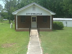
Bellville is a city in the U.S. state of Texas and the seat of Austin County. The city's population was 4,206 at the 2020 census. Bellville is on the eastern edge of the Texas-German belt, and Bellville is known for its German culture and descendants of those Germans still call Bellville home.

References

  1. "2020 U.S. Gazetteer Files". United States Census Bureau. Retrieved December 18, 2021.
  2. 1 2 "U.S. Census website". United States Census Bureau . Retrieved January 31, 2008.
  3. "US Board on Geographic Names". United States Geological Survey. October 25, 2007. Retrieved January 31, 2008.
  4. "New documentary examines first transgender singer in opera history to perform in a principal role".
  5. Krakow, Kenneth K. (1975). Georgia Place-Names: Their History and Origins (PDF). Macon, GA: Winship Press. p. 16. ISBN   0-915430-00-2.
  6. "Evans County". New Georgia Encyclopedia. Retrieved April 2, 2018.
  7. "US Gazetteer files: 2010, 2000, and 1990". United States Census Bureau. February 12, 2011. Retrieved April 23, 2011.
  8. "Geographic Identifiers: 2010 Demographic Profile Data (G001): Bellville city, Georgia". American Factfinder. U.S. Census Bureau. Archived from the original on February 13, 2020. Retrieved January 27, 2016.
  9. "Average Weather for Bellville, Georgia" . Retrieved November 29, 2013.
  10. "Average Weather for Bellvile, GA – Temperature and Precipitation" . Retrieved November 29, 2013.
  11. "Census of Population and Housing". Census.gov. Retrieved June 4, 2015.