The Sun Belt Conference is a collegiate athletic conference that has been affiliated with the NCAA's Division I since 1976. Originally a non-football conference, the Sun Belt began sponsoring football in 2001. Its football teams participate in the Division I Football Bowl Subdivision (FBS). The 12 member institutions of the Sun Belt are distributed primarily across the southern United States.

Junction is a city in and the county seat of Kimble County, Texas, United States. The population was 2,574 at the 2010 census.

The Sun Belt is a region of the United States generally considered to stretch across the Southeast and Southwest. Another rough definition of the region is the area south of the 36th parallel. Within the region, desert/semi-desert, Mediterranean (California), humid subtropical, and tropical climates can be found.

The Gulf Coastal Plain extends around the Gulf of Mexico in the Southern United States and eastern Mexico.

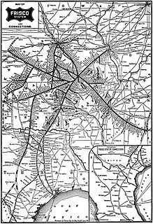
The St. Louis–San Francisco Railway, also known as the Frisco, was a railroad that operated in the Midwest and South Central U.S. from 1876 to April 17, 1980. At the end of 1970 it operated 4,547 miles (7,318 km) of road on 6,574 miles (10,580 km) of track, not including subsidiaries Quanah, Acme and Pacific Railway or the Alabama, Tennessee and Northern Railroad; that year it reported 12,795 million ton-miles of revenue freight and no passengers. It was purchased and absorbed into the Burlington Northern Railroad in 1980. Despite its name, it never came close to San Francisco.

The St. Louis Southwestern Railway, known by its nickname of "The Cotton Belt Route" or simply Cotton Belt, is a former US Class I railroad which operated between St. Louis, Missouri, and various points in the states of Arkansas, Tennessee, Louisiana, and Texas from 1891 to 1980. In 1980 the Cotton Belt began operating the Rock Island's Golden State Route which added the states of Kansas, Oklahoma, and New Mexico to the operation. Operation of the Cotton Belt was assumed by parent Southern Pacific in 1992.

The Texas Blackland Prairies are a temperate grassland ecoregion located in Texas that runs roughly 300 miles (480 km) from the Red River in North Texas to San Antonio in the south. The prairie was named after its rich, dark soil.

The President George Bush Turnpike (PGBT) is a 52-mile (84 km) toll road running through the northern, northeastern and western suburbs, forming a partial loop around Dallas, Texas, United States. It is named for the late George H. W. Bush, the 41st President of the United States. At its west end near Belt Line Road in Irving, State Highway 161 continues southwest to Interstate 20 (I-20) in Grand Prairie. The discontinuous free frontage roads along the turnpike from I-35E in Carrollton east to its end at I-30 in Garland are assigned the State Highway 190 designation. SH 190 signage appears only along the Garland, Richardson, Plano, and Carrollton sections of the frontage road with the undersign "frontage road only". At intersections with city streets, only the Bush Turnpike signs are displayed, not the SH 190 signage. Prior to the construction of the main lanes as a tollway, SH 190 was used as the name of the planned main lanes too. Similarly, the part west of I-35E was planned as part of SH 161. Bush Turnpike is signed as a north–south road from I-20 to I-35E, an east–west road from I-35E to the Merritt Main Lane Gantry and as a north–south road from the Merritt Main Lane Gantry to I-30, as Bush Turnpike makes a nearly 90-degree curve in both places.
The Hunter-Bowen Orogeny was a significant arc accretion event in the Permian and Triassic periods affecting approximately 2,500 km of the Australian continental margin.
Belt Line Road is a loop road that traverses 92 miles (148 km) through 16 cities in Dallas County, Texas. Belt Line Road is the outer complete loop which encircles Dallas, in contrast with I-635 which forms a partial inner loop, Loop 12 which forms a complete inner loop, and President George Bush Turnpike, a partial outer loop. Belt Line Road is not designated as a Texas State Loop, but as a local street in each jurisdiction through which it passes. One stretch of the road is designated as FM 1382 and is maintained by the state. No portion of Belt Line Road is a controlled access freeway.

Southwest Championship Wrestling (SCW) was a professional wrestling promotion that was owned by Joe Blanchard and based in San Antonio, Texas, from 1978 to 1985, when it was purchased by Texas All-Star Wrestling and absorbed into that company.

North Texas Mean Green represents the University of North Texas (UNT) in intercollegiate athletics. The teams compete in Division I of the National Collegiate Athletic Association (NCAA). North Texas competed in the Sun Belt Conference until joining Conference USA (C-USA) on July 1, 2013. UNT's official school colors are green, white and black. North Texas' mascot is an eagle named Scrappy.

The North Texas Mean Green men's basketball team represents the University of North Texas (UNT) in NCAA Division I college basketball, competing as a member of Conference USA.

The Cotton Belt is a region of the Southern United States where cotton was the predominant cash crop from the late 18th century into the 20th century.

The Texas State Bobcats football program is an NCAA Division I-FBS college football team that represents Texas State University. They currently play in the Sun Belt Conference. The program began in 1904 and has an overall winning record. The program has a total of fourteen conference titles, nine of them being outright conference titles. Home games are played at Bobcat Stadium in San Marcos, Texas.

The Fort Worth and Rio Grande Railway, chartered under the laws of Texas on June 1, 1885, was part of a plan conceived by Buckley Burton Paddock and other Fort Worth civic leaders to create a transcontinental route linking New York, Fort Worth, and the Pacific port of Topolobampo, which they believed would stimulate the growth and development of southwest Texas in general, and the economy of Fort Worth in particular.

The St. Louis Southwestern Railway of Texas, operated the lines of its parent company, the St. Louis Southwestern Railway within the state of Texas. The St. Louis Southwestern, known by its nickname of "The Cotton Belt Route" or simply the Cotton Belt, was organized on January 12, 1891, although it had its origins in a series of short rail lines founded in 1870 in Tyler, Texas, that connected northeastern Texas to Arkansas and southeastern Missouri. Construction of the original Tyler Tap Railroad began in the summer of 1875. The St. Louis Southwestern of Texas merged with the property of the Tyler Southeastern Railway on October 6, 1899. The property of the Texas and Louisiana Railway was acquired and merged on July 2, 1903.

Matthews is an unincorporated community on the southeastern edge of Colorado County, in the U.S. state of Texas. The community is located south of Eagle Lake near the junction of FM 102 and FM 950. The settlement was named for a man who owned an area plantation before the American Civil War. By 2013, the school, post office, businesses and railroad line that once served Matthews were gone, but the number of silos in the neighborhood indicated that the land was still being intensively farmed.


