
A swamp is a wetland that is forested. Many swamps occur along large rivers where they are critically dependent upon natural water level fluctuations. Other swamps occur on the shores of large lakes. Some swamps have hammocks, or dry-land protrusions, covered by aquatic vegetation, or vegetation that tolerates periodic inundation or soil saturation. The two main types of swamp are "true" or swamp forests and "transitional" or shrub swamps. In the boreal regions of Canada, the word swamp is colloquially used for what is more correctly termed a bog, fen, or muskeg. The water of a swamp may be fresh water, brackish water or seawater. Some of the world's largest swamps are found along major rivers such as the Amazon, the Mississippi, and the Congo.
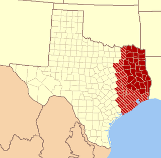
East Texas is a distinct cultural, geographic and ecological area in the U.S. state of Texas.

Caddo Lake is a 25,400-acre (10,300 ha) lake and bayou (wetland) on the border between Texas and Louisiana, in northern Harrison County and southern Marion County in Texas and western Caddo Parish in Louisiana. The lake is named after the Southeastern culture of Native Americans called Caddoans or Caddo, who lived in the area until their expulsion in the 19th century. It is an internationally protected wetland under the Ramsar Convention and includes one of the largest flooded cypress forests in the United States. Caddo is one of Texas's few non-oxbow natural lakes and is the 2nd largest in the South; however, it was artificially altered by the addition of a dam in the 1900s.

Southeast Texas is a sub-region of East Texas located in the southeast corner of the U.S. state of Texas. The sub-region is geographically centered on the Houston–Sugar Land–The Woodlands, and Beaumont–Port Arthur metropolitan areas.

Northeast Texas is a region in the northeast corner of the U.S. state of Texas. It is geographically centered on two metropolitan areas strung along Interstate 20: Tyler in the west and Longview/Marshall to the east. Mount Pleasant, Sulphur Springs, Paris and Texarkana in the north primarily along Interstate 30, Jacksonville and Palestine to the south are also major cities within the region. Most of Northeast Texas is included in the inter-state region of the Arklatex.

The Piney Woods is a temperate coniferous forest terrestrial ecoregion in the Southern United States covering 54,400 square miles (141,000 km2) of East Texas, southern Arkansas, western Louisiana, and southeastern Oklahoma. These coniferous forests are dominated by several species of pine as well as hardwoods including hickory and oak. Historically the most dense part of this forest region was the Big Thicket though the lumber industry dramatically reduced the forest concentration in this area and throughout the Piney Woods during the 19th and 20th centuries. The World Wide Fund for Nature considers the Piney Woods to be one of the critically endangered ecoregions of the United States. The United States Environmental Protection Agency (EPA) defines most of this ecoregion as the South Central Plains.

Somerville Lake is a U.S. Army Corps of Engineers reservoir on Yegua Creek in the Brazos River basin, 10 miles (16 km) northwest of Brenham, Texas, United States. The town of Somerville in Burleson County is adjacent to the reservoir. The lake extends into portions of Burleson County, Washington County, and Lee County. The dam lies in Washington County. The dam and lake are managed by the Fort Worth District of the U.S. Army Corps of Engineers. The reservoir was officially impounded in 1967, and serves to provide flood control and water for irrigation for the communities downstream. Somerville Lake is a popular recreational destination.

Lake Conroe is a 21,000-acre (85 km2) lake in Montgomery County, Texas, United States. Even though it is named Lake Conroe, only a small portion of the lake is in Conroe, Texas. Most of the lake is in unincorporated Montgomery County. The lake lies on the West Fork of the San Jacinto River, just west of Interstate 45 off State Highway 105 in Montgomery and Walker counties. Lake Conroe is a popular attraction for boating, jet-skiing, and fishing.
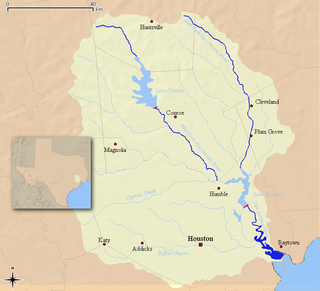
The San Jacinto River runs from Lake Houston in Harris County, Texas, to Galveston Bay. In the past, it was home to the Karankawa and Akokisa tribes. It is named after Saint Hyacinth.

Possum Kingdom State Park is a state park in Palo Pinto County, Texas, USA, that was built in the 1940s by the Civilian Conservation Corps. It covers approximately 1,530 acres (620 ha), and lies in the Palo Pinto Mountains and Brazos River Valley of Texas. The park borders the large Possum Kingdom Lake, a 20,000-acre (8,100 ha) lake known for its clear blue waters. Possum Kingdom winds for 65 miles (105 km) down the Brazos River, and has more than 300 miles (480 km) of shoreline. A privately owned store and marina in the park cater to boaters and campers.

Lake Highlands is a neighborhood constituting most of Northeast Dallas. The neighborhood is a collection of dozens of subdivisions served by RISD public schools, as well as an array of private schools.

Caddo National Grassland is a National Grassland in the southern Great Plains, consisting of two separate sections located in northeastern and southeastern Fannin County, Texas, United States. It is a 17,873-acre (7,233 ha) protected area that was purchased in the 1930s. The goal of the park when purchased was to restore the eroded soil. There are two developed recreation areas around Lake Davy Crockett, which is 388 acres (157 ha) in size. The grassland is divided into two units: Bois d'Arc Creek and Ladonia.

Ratcliff is an unincorporated community in Houston County in east Texas, United States.

The Sam Houston National Forest, one of four National Forests in Texas, is located 50 miles north of Houston. The forest is administered together with the other three United States National Forests and two National Grasslands located entirely in Texas, from common offices in Lufkin, Texas. The units include Angelina, Davy Crockett, Sabine, and Sam Houston National Forests, plus Caddo National Grassland and Lyndon B. Johnson National Grassland. There are local ranger district offices located in New Waverly.
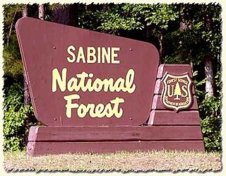
Sabine National Forest is located in East Texas near the Texas-Louisiana border. The forest is administered together with the other three United States National Forests and two National Grasslands located entirely in Texas, from common offices in Lufkin, Texas. There are local ranger district offices located in Hemphill.

Davy Crockett National Forest is off U.S. Highway 69 lying west of Lufkin, Texas and east of Crockett. It is administered by the United States Department of Agriculture Forest Service local headquarters in Lufkin. There are local ranger district offices located in Ratcliff.

Bastrop State Park is a state park in Bastrop County in Central Texas. The park was established in 1938 and consists of stands of loblolly pines mixed with post oak and junipers.
East Dallas, also referred to by the East Dallas Chamber of Commerce as the Lake & Garden District, is an expansive area of numerous communities and neighborhoods in Dallas, Texas that border nearby suburban cities to the east. Such as Garland, Mesquite, and Balch Springs, Texas.
The Little Sandy National Wildlife Refuge is National Wildlife Refuge of 3,802 acres in Wood County, Texas. Unlike most National Wildlife Refuges maintained by the U.S. Fish and Wildlife Service, the public is not allowed access to the refuge. The land is privately owned, but protected by a conservation easement.


