
Saint Paul is the capital of the U.S. state of Minnesota and the county seat of Ramsey County. Situated on high bluffs overlooking a bend in the Mississippi River, Saint Paul is a regional business hub and the center of Minnesota's government. The Minnesota State Capitol and the state government offices all sit on a hill close to the city's downtown district. One of the oldest cities in Minnesota, Saint Paul has several historic neighborhoods and landmarks, such as the Summit Avenue Neighborhood, the James J. Hill House, and the Cathedral of Saint Paul. Like the adjacent city of Minneapolis, Saint Paul is known for its cold, snowy winters and humid summers.

Saint Anthony Falls, or the Falls of Saint Anthony located at the northeastern edge of downtown Minneapolis, Minnesota, is the only natural major waterfall on the Mississippi River. Throughout the mid-to-late 1800’s, various dams were built atop the east and west faces of the falls to support the milling industry that spurred the growth of the city of Minneapolis. In 1880, the central face of the falls was reinforced with a sloping timber apron to stop the upstream erosion of the falls. In the 1950s, the apron was rebuilt with concrete, which makes up the most visible portion of the falls today. A series of locks were constructed in the 1950s and 1960s to extend navigation to points upstream.

The Stone Arch Bridge is a former railroad bridge crossing the Mississippi River at Saint Anthony Falls in downtown Minneapolis, Minnesota. It is the only arched bridge made of stone on the entire Mississippi River. It is the second oldest bridge on the river next to Eads Bridge. The bridge was built to connect the railway system to the new Union Depot, which at that time was planned to be built between Hennepin Avenue and Nicollet Avenue. The bridge was completed in 1883, costing $650,000 at the time. 117 Portland Avenue is the general address of the historic complex.

The Cathedral of Saint Paul is a Roman Catholic cathedral in the city of Saint Paul, Minnesota. It is the co-cathedral of the Archdiocese of Saint Paul and Minneapolis, along with the Basilica of Saint Mary in Minneapolis. One of the most distinctive cathedrals in the United States, it sits on Cathedral Hill overlooking downtown Saint Paul and features a distinctive copper-clad dome. It is dedicated to Paul the Apostle, who is also the namesake of the City of Saint Paul. The current building opened in 1915 as the fourth cathedral of the archdiocese to bear this name. On March 25, 2009, it was designated as the National Shrine of the Apostle Paul by the United States Conference of Catholic Bishops. It is the third-largest Catholic cathedral and sixth-largest church in the United States.
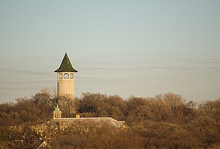
Prospect Park is a historic neighborhood within the University community of the U.S. city of Minneapolis, Minnesota. The area is bounded by the Mississippi River to the south, the City of Saint Paul, Minnesota to the east, the Burlington Northern railroad yard to the north, and the Stadium Village commercial district of the University of Minnesota to the west. The neighborhood is composed of several districts which include the East River Road area. The 1913 Prospect Park Water Tower is a landmark and neighborhood icon.

Nicollet Island is an island in the Mississippi River just north of Saint Anthony Falls in central Minneapolis, Minnesota. According to the United States Census Bureau the island has a land area of 194,407 square metres (0.075 sq mi) and a 2000 census population of 144 persons. The island makes up a large part of the city-designated Nicollet Island/East Bank neighborhood. The island is named for cartographer Joseph Nicollet, who mapped the Upper Mississippi in the 1830s.

The Mississippi National River and Recreation Area is a 72-mile (116 km) and 54,000-acre (22,000 ha) protected corridor along the Mississippi River through the Minneapolis–Saint Paul metro in the U.S. state of Minnesota, from the cities of Dayton and Ramsey, to just downstream of Hastings. This stretch of the upper Mississippi River includes natural, historical, recreational, cultural, scenic, scientific, and economic resources of national significance. This area is the only national park site dedicated exclusively to the Mississippi River. The Mississippi National River and Recreation Area is sometimes abbreviated as MNRRA or MISS, the four letter code assigned to the area by the National Park Service. The Mississippi National River and Recreation Area is classified as one of four national rivers in the United States, and despite its name it is technically not one of the 40 national recreation areas.
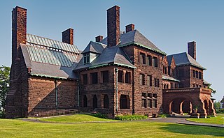
The James J. Hill House in Saint Paul, Minnesota, United States, was built by railroad magnate James J. Hill. The house, completed in 1891, is near the eastern end of Summit Avenue near the Cathedral of Saint Paul. The house, for its time, was very large and was the "showcase of St. Paul" until James J. Hill's death in 1916. It is listed as a U.S. National Historic Landmark, operated by the Minnesota Historical Society. It is also a contributing property to the Historic Hill District.

Minneapolis is the largest city by population in the U.S. state of Minnesota, and the county seat of Hennepin County. The origin and growth of the city was spurred by the proximity of Fort Snelling, the first major United States military presence in the area, and by its location on Saint Anthony Falls, which provided power for sawmills and flour mills.

Clarence Wesley "Cap" Wigington (1883-1967) was an American architect who grew up in Omaha, Nebraska. After winning three first prizes in charcoal, pencil, and pen and ink at an art competition during the Trans-Mississippi Exposition in 1899, Wigington went on to become a renowned architect across the Midwestern United States, at a time when African-American architects were few. Wigington was the nation's first black municipal architect, serving 34 years as senior designer for the City of Saint Paul, Minnesota's architectural office when the city had an ambitious building program. Sixty of his buildings still stand in St. Paul, with several recognized on the National Register of Historic Places. Wigington's architectural legacy is one of the most significant bodies of work by an African-American architect.
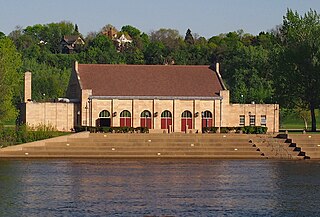
The Harriet Island Pavilion, also known as the Clarence W. Wigington Pavilion, is a park pavilion on Harriet Island just across the Mississippi River from downtown Saint Paul, Minnesota, United States. It was designed by Clarence W. Wigington, the nation's first black municipal architect, and renamed for Wigington after a 2000 restoration. Harriet island was named for Harriet Bishop, a Baptist school teacher from Vermont. She arrived in Saint Paul in 1847, was involved in the temperance movement, and opened the first school in the frontier city, teaching children of diverse ethnic, racial, and religious backgrounds.

Saint Paul, Minnesota, consists of 17 officially defined city districts or neighborhoods.
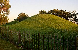
Dayton's Bluff is a neighborhood located on the east side of the Mississippi River in the southeast part of the city of Saint Paul, Minnesota which has a large residential district on the plateau extending backward from its top. The name of the bluff commemorates Lyman Dayton, for whom a city in Hennepin County was also named. On the edge of the southern and highest part of Dayton's Bluff, in Indian Mounds Park, is a series of seven large aboriginal mounds, 4 to 18 feet high, that overlook the river and the central part of the city.

This is a list of the National Register of Historic Places listings in Dakota County, Minnesota. It is intended to be a complete list of the properties and districts on the National Register of Historic Places in Dakota County, Minnesota, United States. Dakota County is located in the southeastern part of the U.S. state of Minnesota, bounded on the northeast side by the Upper Mississippi River and on the northwest by the Minnesota River. The locations of National Register properties and districts for which the latitude and longitude coordinates are included below, may be seen in an online map.

The Village of East Davenport, also known simply as The Village, is located along the Mississippi River on the southeast side of Davenport, Iowa, United States. It was listed as a historic district on the National Register of Historic Places in 1980 as the Davenport Village. At the time of its nomination it included 145 contributing properties, most of which were working-class housing.

Saint Paul is the second largest city in the U.S. state of Minnesota, the county seat of Ramsey County, and the state capital of Minnesota. The origin and growth of the city were spurred by the proximity of Fort Snelling, the first major United States military installation in the area, as well as by the city's location on the northernmost navigable port of the Upper Mississippi River.

The St. Louis County Depot is a historic railroad station in Duluth, Minnesota, United States. It was built as a union station in 1892, serving seven railroads at its peak. Rail service ceased in 1969 and the building was threatened with demolition until it reopened in 1973 as St. Louis County Heritage & Arts Center . Train service also resumed from 1974 to 1985, by Amtrak.

The Lucas Kuehn House is a historic house in Wabasha, Minnesota, United States. It was built in 1878 for Lucas Kuehn (1834–?), the city's leading merchant of the 19th century. The house was the city's first to be designed in the Italianate style. It was also part of a unique trend among Wabasha's merchant class for houses constructed of brick. It was listed on the National Register of Historic Places in 1994 for its local significance in the themes of architecture and commerce. It was nominated for its associations with Kuehn and for its exemplary Italianate architecture.

The Davenport Downtown Commercial Historic District is a nationally recognized historic district located in the central business district of Davenport, Iowa, United States. It was listed on the National Register of Historic Places in 2020. At the time of its nomination it consisted of 43 resources, which included 33 contributing buildings, one contributing structure, and nine non-contributing buildings. In addition, the district also contains 33 buildings that are individually listed on the National Register. This historic district is bordered by four other districts: the Crescent Warehouse Historic District and the Davenport Motor Row and Industrial Historic District on the east, the Hamburg Historic District to the northwest, and the West Third Street Historic District on the west.
Benjamin Wetherill Brunson (1823–1898) was an American surveyor and politician who served in the Minnesota Territorial House of Representatives from 1849 until 1852. He was one of the original platters of Saint Paul, Minnesota.


