
Aoraki / Mount Cook is the highest mountain in New Zealand. Its height, as of 2014, is listed as 3,724 metres. It sits in the Southern Alps, the mountain range that runs the length of the South Island. A popular tourist destination, it is also a favourite challenge for mountain climbers. Aoraki / Mount Cook consists of three summits: from south to north, the Low Peak, the Middle Peak and the High Peak. The summits lie slightly south and east of the main divide of the Southern Alps, with the Tasman Glacier to the east and the Hooker Glacier to the southwest. Mount Cook is ranked 10th in the world by topographic isolation.

Omarama is a small town at the junction of State Highways 8 and 83, near the southern end of the Mackenzie Basin, in the South Island of New Zealand. Omarama is in the Waitaki District, in the southern Canterbury region. The Ahuriri River is a short distance to the north of the township. Omarama is 30 km southwest of Twizel, 40 km southeast of Lake Ōhau and 32 km northeast of the Lindis Pass.

The Southern Alps are a mountain range extending along much of the length of New Zealand's South Island, reaching its greatest elevations near the range's western side. The name "Southern Alps" generally refers to the entire range, although separate names are given to many of the smaller ranges that form part of it.

The Mackenzie Basin, popularly and traditionally known as the Mackenzie Country, is an elliptical intermontane basin located in the Mackenzie and Waitaki Districts, near the centre of the South Island of New Zealand. It is the largest such basin in New Zealand. Historically famous mainly for sheep farming, the sparsely populated area is now also a popular tourism destination.
Tongariro National Park is the oldest national park in New Zealand, located in the central North Island. It has been acknowledged by UNESCO as a World Heritage Site of mixed cultural and natural values.

Lake Ōhau is a lake in the Mackenzie Basin in the South Island of New Zealand. The Hopkins and Dobson rivers fed into the northern end of Lake Ōhau. These rivers have their headwaters in the Southern Alps. The lake's outflow is the Ōhau River, which travels from the southeast corner of Lake Ōhau and feeds into the Waitaki River hydroelectric project. The Barrier range dominate the western side of Lake Ōhau, while the Ben Ohau range dominates the eastern side of Lake Ōhau. At the northern end of the lake, in between the Hopkins and Dobson rivers, lies the Naumann Range of mountains.
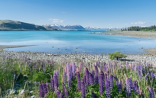
Lake Tekapo is the second-largest of three roughly parallel lakes running north–south along the northern edge of the Mackenzie Basin in the South Island of New Zealand. It covers an area of 83 km2 (32 sq mi) and is at an altitude of 710 m (2,330 ft) above sea level.

The Tararua Range, often referred to as the Tararua Ranges or Tararua, is one of several mountain ranges in the North Island of New Zealand.

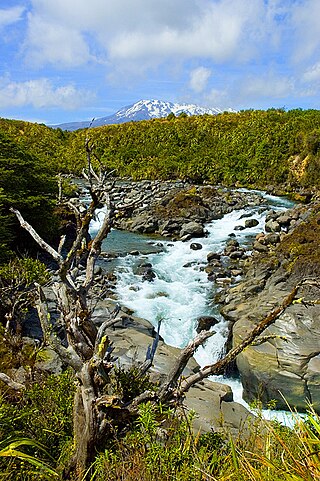
The North Island Volcanic Plateau is a volcanic plateau covering much of central North Island of New Zealand with volcanoes, lava plateaus, and crater lakes. It contains the Taupō caldera complex, Ōkataina caldera complex and Tongariro Volcanic Centre resulting in it being currently the most frequently active and productive area of silicic volcanism on Earth. New Zealand is part of the Pacific Ring of Fire.

Tussock grasslands form expansive and distinctive landscapes in the South Island and, to a lesser extent, in the Central Plateau region of the North Island of New Zealand. Most of the plants referred to as tussocks are in the genera Chionochloa, Festuca, and Poa, also Carex.

Pureora Forest Park is a 760-square-kilometre (290 sq mi) protected area in the North Island of New Zealand. Within its rich rainforest are an abundance of 1,000-year-old podocarp trees. It is "recognised as one of the finest rain forests in the world". Established in 1978, after a series of protests and tree sittings, the park is one of the largest intact tracts of native forest in the North Island and has high conservation value due to the variety of plant life and animal habitats. New Zealand's largest totara tree is located nearby on private land.

The North Island temperate forests, also known as the Northland temperate forests, is a temperate broadleaf and mixed forests ecoregion on New Zealand’s North Island.

The Canterbury–Otago tussock grasslands is an ecoregion of the South Island, New Zealand, part of the wider tussock grasslands of New Zealand.

The Southland montane grasslands, also known as the South Island montane grasslands, is a montane grasslands and shrublands ecoregion on New Zealand’s South Island. The ecoregion covers the middle portion of the Southern Alps, and includes extensive alpine grasslands, fellfields, and montane forests.

The Alps 2 Ocean Cycle Trail is a cycle trail in New Zealand. This trail is one of the projects of the New Zealand Cycle Trail project. The trail extends more than 300 kilometres (190 mi) from Aoraki / Mount Cook to Oamaru on the Pacific Ocean. From west to east, it descends from an altitude of 780 metres (2,560 ft) down to sea level. The trail has both on and off-road sections.

The Braeburn Range is a mountain range in the Tasman Region of New Zealand's South Island. It lies to the west of Lake Rotoroa and much of the eastern flank of the range is within the Nelson Lakes National Park. The range runs south-southeast, with a westwards curve at the northern end and several westward-trending spurs.

Chionochloa rigida, known commonly as narrow-leaved snow tussock and by its Māori name wī kura, is a species of tussock grass endemic to New Zealand. Two subspecies are recognised, including Chionochloa rigida rigida and Chionochloa rigida amara.

The Southland temperate forests is a temperate broadleaf and mixed forests ecoregion on New Zealand's South Island. The natural vegetation was mostly forest, but over the centuries human activities, including grazing and fires, replaced much of the original forest with grassland and agriculture.

The Pisa Range is a mountain range in Central Otago, in the South Island of New Zealand. It lies on the western shore of the man-made Lake Dunstan and overlooks the town of Cromwell. Its highest point, Mount Pisa, is 1,963 m.


