
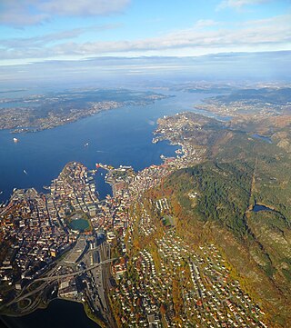
Bergen, historically Bjørgvin, is a city and municipality in Vestland county on the west coast of Norway. As of 2022, its population was roughly 289,330. Bergen is the second-largest city in Norway after the national capital Oslo. The municipality covers 465 square kilometres (180 sq mi) and is on the peninsula of Bergenshalvøyen. The city centre and northern neighbourhoods are on Byfjorden, 'the city fjord'. The city is surrounded by mountains, causing Bergen to be called the "city of seven mountains". Many of the extra-municipal suburbs are on islands. Bergen is the administrative centre of Vestland county. The city consists of eight boroughs: Arna, Bergenhus, Fana, Fyllingsdalen, Laksevåg, Ytrebygda, Årstad, and Åsane.

Årstad is a borough in the city of Bergen in Vestland county, Norway. Historically, the area was a separate municipality called Årstad until 1916, when it was merged into the city of Bergen. The borough has similar boundaries to those of the old municipality.

Bryggen, also known as Tyskebryggen, is a series of Hanseatic heritage commercial buildings lining up the eastern side of the Vågen harbour in the city of Bergen, Norway. Bryggen has been on the UNESCO list for World Cultural Heritage sites since 1979.

Buekorps are traditional marching neighbourhood youth organizations in Bergen, Norway.

Sandviken is a traditional neighbourhood of the city of Bergen in Vestland county, Norway.
Bergen landdistrikt is a former municipality in the old Hordaland county in Norway. The municipality existed from 1838 until 1877 when it was merged into the neighboring city of Bergen. Bergen landdistrikt encompassed about 5 square kilometres (1.9 sq mi) of land surrounding the city of Bergen, including the present neighborhoods of Møhlenpris, Nygård, Kalfaret, Sandviken, and Ytre Sandviken as well as the mountains Fløyfjellet and Sandviksfjellet.
Bergenhus len was an administrative division of the Kingdom of Norway that existed from 1503 to 1662, with the Bergenhus Fortress in Bergen as its administrative center Norwegian administrative division. The len was changed to an amt (district) in 1662 but it kept its original name and capital until 1919.

Nordnes is a peninsula and neighbourhood in the city centre of Bergen in Vestland county, Norway.

Nygård is a neighbourhood in the city centre of Bergen in Vestland county, Norway. It is located south of the Lille Lungegårdsvannet lake in the city centre and north of the Møhlenpris neighborhood. Grieghallen, St. Jacob's Church, and parts of the University of Bergen are located in Nygård.

Møhlenpris is a neighbourhood in the city of Bergen in Vestland county, Norway. It is next to the Puddefjorden in the borough of Bergenhus. The neighbourhood is named after Jørgen Thor Møhlen, who was a shipowner, slave trader, innovator and businessman who established some industry at Møhlenpris in the late 17th century. Most of the buildings date from the late 19th and early 20th centuries.
Store Lungegårdsvannet is a bay located in the city and municipality of Bergen in Vestland county, Norway. The bay separates the city centre, located in the borough of Bergenhus, from the southern boroughs of the city, Årstad, Fana and Ytrebygda. The bay is situated at the end of the Puddefjorden.

Bergen Tramway was a tram in Bergen, Norway. It was in operation from 1897 to 1965. The first three lines were opened on 29 June 1897. Starting in 1950, tramway lines were gradually replaced with bus and trolleybus routes. The last line closed in 1965. Since 1993, a heritage tram is operated in Møhlenpris by the Bergen's Electric Tramway association. A light rail system was proposed in 1995, adopted in the 2000s and started operating in 2010.

Kalfaret is a neighborhood in the city of Bergen in Vestland county, Norway. The neighborhood is located in the borough of Bergenhus, just north of the Store Lungegårdsvannet bay, east of the city centre. The area is an affluent neighborhood, although it is close to the main train line that runs into Bergen Station.

Munkeliv Abbey was a Benedictine abbey located at Nordnes in Bergen, Norway. It was one of the oldest monasteries in Norway, and also one of the wealthiest and best-documented. There are no visible remains today.

Puddefjorden, often anglicized as Pudde Fjord, is an inlet or fjord in the central part of the city of Bergen in Vestland county, Norway. An arm off of the main Byfjorden, the Puddefjorden is 3.5 kilometres (2.2 mi) long and stretches from the tip of the Nordnes peninsula to the Solheimsviken bay at the entrance to the Store Lungegårdsvannet bay. The fjord is 1.2 kilometres (0.75 mi) at its widest, between Nordnes and the inner part of the borough of Laksevåg. The innermost part of the fjord, known as Damsgårdssundet, is much narrower, scarcely 100 metres (330 ft) wide at its narrowest. The fjord is located next to some of Bergen's most important industrial areas, and has played a significant part in the city's development and industrialisation.

Strandgaten is a street in the city centre of Bergen, Norway, west of the bay of Vågen. It starts at Torgallmenningen and follows the eastern shore of the Nordnes peninsula to Tidemands gate, where it becomes Nordnesgaten. The easternmost quarter of Strandgaten is a regular two-way street, while it is an eastbound one-way street between Tollbodallmenningen and Holbergsallmenningen, and between Østre Murallmenningen and Torgallmenningen. Between Holbergsallmenningen and Østre Murallmenningen the street is pedestrianised. In total, Strandgaten is approximately 1.2 km long.

Vågen is a bay in the centre of the city of Bergen in Vestland county, Norway. It is the central harbour of the city centre, and is the center of the historical core of the city. The city of Bergen originated on the east shore of the bay, and from there it expanded to the southern and western shores over a few centuries. Today, Bergen is the second largest city in the nation.
Christ Church on Holmen was the main medieval era cathedral of Bergen, Norway. Its site was near Haakon's hall (Håkonshallen) and Bergenhus Fortress .

Vågsbygd is a borough and district in the city of Kristiansand which lies in the municipality of Kristiansand in Agder county, Norway. It is the largest borough and district in Kristiansand. Until 1965, Vågsbygd was a part of Oddernes municipality. The borough includes the districts of Flekkerøy, Voiebyen, Vågsbygd/Augland, and Slettheia. The Kristiansand Cannon Museum on Kroodden is an authentic fortress from World War II.
The following is a timeline of the history of the city of Bergen, Norway.


